Cima Ciantiplagna

Last updated
Cima Ciantiplagna
Cima Ciantiplagna.JPG
The mountain seen from Punta delle Vallette
Highest point
Elevation 2,849 m (9,347 ft) [1]
Prominence 679 m (2,228 ft) [2] [3]
Parent peak Monte Orsiera
Isolation 6.77 km (4.21 mi)  OOjs UI icon edit-ltr-progressive.svg
Listing Alpine mountains 2500-2999 m
Coordinates 45°04′22″N7°01′12″E / 45.0728°N 7.0201°E / 45.0728; 7.0201 Coordinates: 45°04′22″N7°01′12″E / 45.0728°N 7.0201°E / 45.0728; 7.0201
Geography
Alps location map.png
Red triangle with thick white border.svg
Cima Ciantiplagna
Location in the Alps
Location Piedmont, Italy
Parent range Cottian Alps
Climbing
Easiest route hiking

The Cima Ciantiplagna is a mountain in the Cottian Alps belonging to the Province of Turin (Italy).

Contents

Geography

The Ciantiplagna as seen from Val Clarea, on the Susa Valley opposite side Frais da val clarea sfondo ciantiplagna.jpg
The Ciantiplagna as seen from Val Clarea, on the Susa Valley opposite side

The mountain stands on the long ridge which, starting from Sestriere, divides the Susa Valley from Chisone valley, W of the colle delle Finestre. Despite being shaped as an inconspicuous, grassy bump, it's the highest mountains of the area between Colle delle Finestre and Sestriere. [4] Close to its summit passes an old military road built in order to deserve several military emplacements. It's a dirt road connecting Pian dell'Alpe (Usseaux) with Sestriere, open to cars and motorbikes during summertime.

SOIUSA classification

According to SOIUSA (International Standardized Mountain Subdivision of the Alps) the mountain can be classified in the following way: [5]

Access to the summit

Summit cross Vetta Ciantiplagna.JPG
Summit cross

The summit of the Ciantiplagna is easy to reach, and the normal route starts from the old military road linking Sestriere with Colle delle Finestre and briefly follows the NE ridge of the mountain up to its top, [4] marked by a metallic summit cross. It also can be attained by mountain bike. [6] Besides summer hiking the Ciantiplagna is also a popular ski mountaineering destination. [7]

Nature conservation

The mountain and its surrounding area are included in a regional nature park called Parco naturale Orsiera - Rocciavrè, which also is the SIC (Site of Community Importance) of code IT1110006. [8]

Related Research Articles

Pointe de Paumont

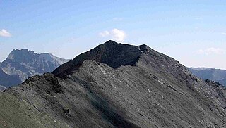
Pointe de Paumont or Cima del Vallone is a mountain of Savoie, France and of the Province of Turin, Italy. It lies in the Cottian Alps range. It has an elevation of 3,171 metres above sea level.

Punta Bagnà

Punta Bagnà or Cime du Grand Vallon is a mountain of Savoie, France and of the Province of Turin, Italy. It lies in the Cottian Alps range. It has an elevation of 3,129 metres above sea level.

Punta Sommeiller

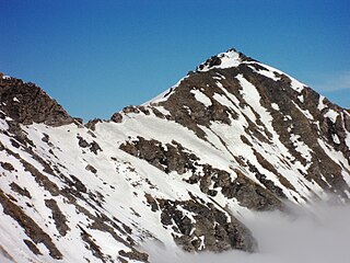
Punta Sommeiller or Pointe Sommeiller is a mountain of the Province of Turin, Italy and of Savoie, France. It lies in the Cottian Alps range. It has an elevation of 3,333 metres (10,935 ft) above sea level.

Rognosa dEtiache

Rognosa d'Etiache or Rognosa d'Étache is a mountain in the Cottian Alps on the border of Turin, Italy, and Savoie, France. It has an elevation of 3,382 metres above sea level.

Monte Orsiera

Monte Orsiera is a mountain in the Cottian Alps belonging to the Province of Turin (Italy).

Bric Ghinivert Mountain in Italy

Bric Ghinivert or Eiminàl is a mountain of the Cottian Alps located in Italy.

Monte Politri Mountain in Italy

Monte Politri or Bric Rosso is a 3,026 m a.s.l. mountain of the Cottian Alps, located in Italy.

Monte Albergian Mountain in Italy

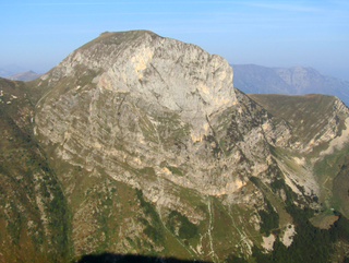
Monte Albergian is a 3,041 m a.s.l. mountain of the Cottian Alps, located in Italy. A battalion of 3rd Alpini Regiment, which during World War I earned a Silver Medal of Military Valor, was named after Monte Albergian.

Punta Tempesta Mountain in Italy

Punta Tempesta is a 2,679 m a.s.l. mountain of the Cottian Alps, located in Italy.

Cima di Pertegà

Cima di Pertegà (Italian) or Cime de la Pertègue (French) is a mountain located on the French-Italian border between Piemonte and Provence-Alpes-Côte d'Azur.

Punta Merciantaira

The Punta Merciantaira or Grand Glaiza is a 3,293 metres high mountain of the Cottian Alps.

Grand Queyron

The Gran Queyron or Grand Queyron is a 3,060 metres high mountain of the Cottian Alps.

Mongioia

The Cima Mongioia or simply Mongioia or Bric de Rubren is a 3,340 metres high mountain of the Cottian Alps.

Punta Nera

The Punta Nera is a mountain of Savoie (France) and of the Province of Turin (Italy). It lies in the Cottian Alps range. It has an elevation of 3,047 metres above sea level.

Pointe Rochers Charniers Mountain in France

The Pointe Rochers Charniers is a mountain of the Cottian Alps at an elevation of 3,063 metres above sea level, located in France.

Cime de Missun

The Cime de Mussun (French) or Cima Missun (Italian) is a mountain of the Ligurian Alps.

Monte I Gemelli Mountain in Italy

The Monte I Gemelli is an Alpine mountain located between Aosta Valley and Piedmont.

Punta Cornour Mountain in Italy

The Punta Cornour is a 2,868 metres high mountain on the Italian side of the Cottian Alps.

Monte Birrone Mountain in Italy

The Monte Birrone is a 2,131-metre (6,991 ft) high mountain in the Cottian Alps, belonging to the Italian province of Cuneo.

Cima Cars Mountain in Italy

The Cima Cars is a mountain of the Ligurian Alps located in Piedmont.

References

  1. AA.VV. (1961). Piemonte (eccetto Torino e Valle d'Aosta). Touring club italiano - Garzanti. p. 410. Retrieved 2020-04-13.
  2. Cima Ciantiplagna, Italy at Peakbagger.com
  3. Key col: Colle delle Finestre (2,710 m)
  4. 1 2 Ferreri, Eugenio (1982). "404. Cima Ciantiplagna". Alpi Cozie centrali. Guida dei Monti d'Italia (in Italian). Milano: CAI / TCI. p. 278.
  5. Marazzi, Sergio (2005). Atlante Orografico delle Alpi. SOIUSA (in Italian). Priuli & Verlucca. p. 88. ISBN   978-88-8068-273-8.
  6. A.Peverada (2017-08-09). "Cima Ciantiplagna" (in Italian). Retrieved 2020-04-13.
  7. garbo zeneixi (2017-02-21). "Ciantiplagna (Cima) da Frais" (in Italian). gulliver.it. Retrieved 2020-04-13.
  8. Siti di Importanza Comunitaria (SIC), Regione Piemonte, list on gis.csi.it Archived 2016-03-03 at the Wayback Machine (accessed in September 2011)

Maps