
Southeast Alaska, often abbreviated to southeast or southeastern, and sometimes called the Alaska(n) panhandle, is the southeastern portion of the U.S. state of Alaska, bordered to the east and north by the northern half of the Canadian province of British Columbia. The majority of southeast Alaska is situated in Tlingit Aaní, much of which is part of the Tongass National Forest, the United States' largest national forest. In many places, the international border runs along the crest of the Boundary Ranges of the Coast Mountains. The region is noted for its scenery and mild, rainy climate.

Craig is a city in the Prince of Wales-Hyder Census Area in the Unorganized Borough in the U.S. state of Alaska. The population was 1,036 at the 2020 census, down from 1,201 in 2010.

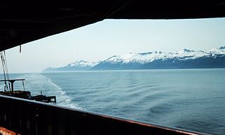
The Gulf of Alaska is an arm of the Pacific Ocean defined by the curve of the southern coast of Alaska, stretching from the Alaska Peninsula and Kodiak Island in the west to the Alexander Archipelago in the east, where Glacier Bay and the Inside Passage are found.

Prince of Wales Island is one of the islands of the Alexander Archipelago in the Alaska Panhandle. It is the fourth-largest island in the United States and the 97th-largest island in the world.
Clarence Strait, originally Duke of Clarence Strait, is a strait in southeastern Alaska, in the United States in the Alexander Archipelago. The strait separates Prince of Wales Island, on the west side, from Revillagigedo Island and Annette Island, on the east side. Clarence Strait is 126 miles (203 km) long, extending from Dixon Entrance to Sumner Strait. Moira Sound is on the west side of the strait.

Sumner Strait is a strait in the Alexander Archipelago in the southeastern region of the U.S. state of Alaska. It is about 80 miles (130 km) long and 10 miles (16 km) wide, extending from the mouth of the Stikine River to Iphigenia Bay on the Gulf of Alaska, separating Mitkof Island, Kupreanof Island, and Kuiu Island on the north from Zarembo Island and Prince of Wales Island on the south.

Dall Island is an island in the Alexander Archipelago off the southeast coast of Alaska, just west of Prince of Wales Island and north of Canadian waters. Its peak elevation is 2,443 feet above sea level. Its land area is 254.0 square miles (657.9 km2), making it the 28th largest island in the United States. Dall is used economically for fishing and limestone quarrying.

Kosciusko Island is an island in the Alexander Archipelago of southeastern Alaska, United States. It lies near the northwest corner of Prince of Wales Island, just across the El Capitan Passage from the larger island.
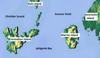
Warren Island is an island in the Alexander Archipelago of southeastern Alaska, United States. It lies on the Pacific coast just southwest of the community of Edna Bay. Directly west is Coronation Island and directly north is Kuiu Island. Warren Island has a land area of 47.191 km2 and no permanent resident population. The entire island has been designated as the Warren Island Wilderness, a part of Tongass National Forest.

During the Age of Discovery, the Spanish Empire undertook several expeditions to the Pacific Northwest of North America. Spanish claims to the region date to the papal bull of 1493, and the Treaty of Tordesillas signed in 1494. In 1513, this claim was reinforced by Spanish explorer Vasco Núñez de Balboa, the first European to sight the Pacific Ocean, when he claimed all lands adjoining this ocean for the Spanish Crown. Spain only started to colonize the claimed territory north of present-day Mexico in the 18th century, when it settled the northern coast of Las Californias.

Heceta Island is an island in the Alexander Archipelago of southeastern Alaska, United States. It lies just off the west coast of Prince of Wales Island. Kosciusko Island lies to its north, while Tuxekan Island lies to its northeast. Directly to its south are the Maurelle Islands group, while further south are Noyes Island, Lulu Island, and San Fernando Island. The island's area is 181.0 km2.
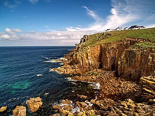
A headland, also known as a head, is a coastal landform, a point of land usually high and often with a sheer drop, that extends into a body of water. It is a type of promontory. A headland of considerable size often is called a cape. Headlands are characterised by high, breaking waves, rocky shores, intense erosion, and steep sea cliff.
Palaeoaplysina is a genus of tabular, calcified fossils that are a component of many Late Palaeozoic reefs. The fossil acted as a baffle to trap sediment. Historically interpreted as a sponge or hydrozoan, recent studies are converging to its classification in the coralline stem group, placing it among the red algae.

Reticulosa is an extinct order of sea sponges in the class Hexactinellida and the subclass Amphidiscophora. Reticulosans were diverse in shape and size, similar to their modern relatives, the amphidiscosidans. Some were smooth and attached to a surface at a flat point, others were polyhedral or ornamented with nodes, many were covered in bristles, and a few were even suspended above the seabed by a rope-like anchor of braided glass spicules.
Nuluk River is a waterway on the Seward Peninsula in the U.S. state of Alaska. It enters the Ikpek Lagoon 40 miles (64 km) northeast of Cape Prince of Wales. It heads in the high mountains made up of the Port Clarence limestone about 35 miles south of the Arctic Ocean. For 15 miles (24 km) from its head, the river occupies a canyon, varying from 100–1,000 feet (30–305 m) in depth, cut in Silurian limestones. Fossils have been reported about the head of the river. Northward along its course, the character of the bed rock changes, and calcareous mica-schists are noted. The Silurian limestones dip toward the schists, and near the contact with them, are very highly folded. The coastal plain gravel extends inland farther along the Nuluk River than it does on the other rivers of this region.
The Heceta Limestone is a geologic formation in Alaska. It preserves fossils dating back to the Silurian period.

Romundina is a small, heavily armored extinct genus of acanthothoracid placoderms which lived in shallow marine environments in the early Devonian (Lochkovian). The name Romundina honors Canadian geologist and paleontologist Dr. Rómundur (Raymond) Thorsteinsson of Calgary, Alberta, Canada. Romundina are believed to have lived on Earth between 400 and 419 million years ago. The closest known relative to Romundina is the acanthothoracid Radotina. The type and only described species is R. stellina.
The geology of Alaska includes Precambrian igneous and metamorphic rocks formed in offshore terranes and added to the western margin of North America from the Paleozoic through modern times. The region was submerged for much of the Paleozoic and Mesozoic and formed extensive oil and gas reserves due to tectonic activity in the Arctic Ocean. Alaska was largely ice free during the Pleistocene, allowing humans to migrate into the Americas.

Coalbrookdale Formation, earlier known as Wenlock Shale or Wenlock Shale Formation and also referred to as Herefordshire Lagerstätte in palaeontology, is a fossil-rich deposit (Konservat-Lagerstätte) in Powys and Herefordshire at the England–Wales border in UK. It belongs to the Wenlock Series of the Silurian Period within the Homerian Age. It is known for its well-preserved fossils of various invertebrate animals many of which are in their three-dimensional structures. Some of the fossils are regarded as earliest evidences and evolutionary origin of some of the major groups of modern animals.
Dudleyaspis is an extinct genus of Lower to Middle Devonian odontopleurid trilobites that lived in a shallow sea that lay between Euramerica and Gondwana. It was named in 1949 by Prantl & Pribyl.