Kemerovo is an industrial city and the administrative center of Kemerovo Oblast, Russia, located at the confluence of the Iskitimka and Tom Rivers, in the major coal mining region of the Kuznetsk Basin. Population: 557,119 (2021 Census); 532,981 (2010 Census); 484,754 (2002 Census); 520,263 (1989 Soviet census).

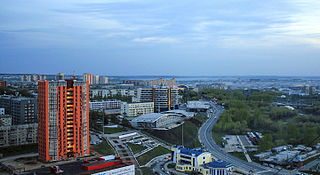
Omsk is the administrative center and largest city of Omsk Oblast, Russia. It is situated in southwestern Siberia and has a population of over 1.1 million. Omsk is the third largest city in Siberia after Novosibirsk and Krasnoyarsk, and the twelfth-largest city in Russia. It is an important transport node, serving as a train station for the Trans-Siberian Railway and as a staging post for the Irtysh River.

Omsk Oblast is a federal subject of Russia, located in southwestern Siberia. The oblast has an area of 139,700 square kilometers (53,900 sq mi). Its population is 1,977,665 with the majority, 1.12 million, living in Omsk, the administrative center.

Znamensky District is the name of several administrative and municipal districts in Russia.

Tara is a town in Omsk Oblast, Russia, located at the confluence of the Tara and Irtysh Rivers at a point where the forested country merges into the steppe, about 300 kilometers (190 mi) north of Omsk, the administrative center of the oblast. Population: 27,318 (2010 Census); 26,888 (2002 Census); 26,152 (1989 Soviet census).

Isilkul is a town in Omsk Oblast, Russia, located 120 kilometers (75 mi) west of Omsk, the administrative center of the oblast. Population: 24,482 (2010 Census); 26,549 (2002 Census); 26,430 (1989 Soviet census).
Nazyvayevsk is a town in Omsk Oblast, Russia, located 120 kilometers (75 mi) west of Omsk, the administrative center of the oblast. As of the 2010 Census, its population was 11,615.

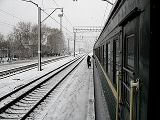
Kalachinsk is a town in Omsk Oblast, Russia, located on the Om River along the busiest segment of the Trans-Siberian Railway, 100 kilometers (62 mi) east of Omsk, the administrative center of the oblast. Population: 23,556 (2010 Census); 24,247 (2002 Census); 25,014 (1989 Soviet census).
Tyukalinsk is a town in Omsk Oblast, Russia, located 60 kilometers (37 mi) northeast of the Nazyvayevsk railway station on the Trans-Siberian Railway and 120 kilometers (75 mi) northwest of Omsk, the administrative center of the oblast. Population: 11,275 (2010 Census); 12,007 (2002 Census); 12,191 (1989 Soviet census).
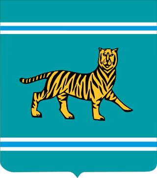
The coat of arms of the Jewish Autonomous Oblast is the official coat of arms of the Jewish Autonomous Oblast in Russia. It consists of a Siberian tiger standing on four legs with the tail and the head turned upwards, of which the latter is facing the observer. This specific position and occurrence of the tiger symbolizes the history and development of the Oblast. The coat is a heraldic French shield and the background represents the color of the geographical characteristics of the Russian Far East, which includes taigas, hills, and meadows.
Krutinsky District is an administrative and municipal district (raion), one of the thirty-two in Omsk Oblast, Russia. It is located in the west of the oblast. The area of the district is 5,700 square kilometers (2,200 sq mi). Its administrative center is the urban locality of Krutinka. Population: 17,408 ; 21,287 (2002 Census); 23,411 (1989 Soviet census). The population of Krutinka accounts for 42.1% of the district's total population.

Maryanovsky District is an administrative and municipal district (raion), one of the thirty-two in Omsk Oblast, Russia. It is located in the southwest of the oblast. The area of the district is 1,700 square kilometers (660 sq mi). Its administrative center is the urban locality of Maryanovka. Population: 27,595 ; 27,802 (2002 Census); 30,173 (1989 Soviet census). The population of Maryanovka accounts for 31.3% of the district's total population.
The flag of the Irkutsk Oblast depicts three vertical stripes in the ratio 1:2:1: blue on the hoist and fly and white in the middle. Within the white strip, a stylized black tiger-beaver hybrid is seen holding a red sable in its mouth. These two are surrounded by branches of cedar. The blue represents the waters of Lake Baikal, while white represents purity, goodness, and honesty. The green of the cedar branches represents hope, joy, and abundance.

The coat of arms of the Bryansk Oblast was approved by the Bryansk Oblast Duma on November 5, 1998. According to the official description provided by the legislature of the oblast, the arms of the Bryansk Oblast "reflect the characteristic features of the area and its inhabitants: industry and patriotism.
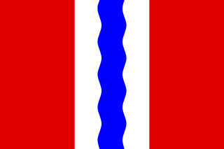
The flag of Omsk Oblast is the official symbol of Omsk Oblast in Russia.

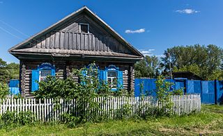
Azovo is a rural locality and the administrative center of Azovsky Nemetsky National District of Omsk Oblast, Russia. Population: 5,997 (2010 Census); 5,376 (2002 Census);

The coat of arms of Sevastopol is a heraldic symbol representing the city of Sevastopol, Crimea. It is featured in the middle of the flag of Sevastopol on a red background.

Alexander Leonidovich Burkov is a Russian politician who served as governor of Omsk Oblast from 2017 to 2023. He is a member of the Central Council of A Just Russia — For Truth party.
The 2023 Omsk Oblast gubernatorial election took place on 9–10 September 2023, on common election day. Acting Governor Vitaliy Khotsenko was elected for a full term.

The coat of arms of Smolensk is the official heraldic symbol of the city of Smolensk, Smolensk region, Russia. A bird Gamayun on a sable cannon with an or gun carriage is depicted on an argent escutcheon. The coat of arms is embellished with a number of honourable decorations that depict the history of the city.