Irkutsk is the largest city and administrative center of Irkutsk Oblast, Russia. With a population of 587,891 as of the 2010 Census, Irkutsk is the 25th-largest city in Russia by population, the fifth-largest in the Siberian Federal District, and one of the largest cities in Siberia.

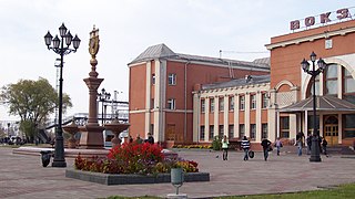
Birobidzhan, also spelt Birobijan, is a town and the administrative centre of the Jewish Autonomous Oblast, Russia, located on the Trans-Siberian Railway, near the China–Russia border.

The Russian Far East is a region in North Asia. It is the easternmost part of Russia and the Asian continent, and is coextensive with the Far Eastern Federal District, which encompasses the area between Lake Baikal and the Pacific Ocean. The area's largest city is Khabarovsk, followed by Vladivostok. The region shares land borders with the countries of Mongolia, China, and North Korea to its south, as well as maritime boundaries with Japan to its southeast, and with the United States along the Bering Strait to its northeast.

The state flag of the Sakha Republic (Yakutia) in Russia is one of the official symbols of the Sakha Republic, alongside the coat of arms and the national anthem of the Sakha Republic. The flag has four horizontal stripes. From top to bottom, the stripes are light blue, white (1/16), red (1/16), and green (1/8). The flag has been used officially as the flag of the Sakha Republic since 14 October 1992. The light blue stripe is charged with a white disc in the center. The diameter of the disc is 2/5 of the flag's width.

The Far Eastern Economic Region is one of twelve economic regions of Russia.
Obluchye is a town and the administrative center of Obluchensky District in the Jewish Autonomous Oblast, Russia, located on the Khingan River, 159 kilometers (99 mi) west of Birobidzhan, the administrative center of the autonomous oblast. Population: 7,959 (2021 Census); 9,379 (2010 Census); 11,069 (2002 Census); 12,016 (1989 Soviet census).
Nizhneleninskoye is a rural locality in Leninsky District of the Jewish Autonomous Oblast. Located on the Amur River, Nizhneleninskoye is the location for the Tongjiang-Nizhneleninskoye railway bridge which crosses over the river to China, joining it by a railway bridge to Tongjiang in Heilongjiang Province.

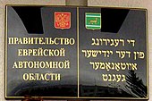
The Jewish Autonomous Oblast is the only Autonomous Oblast in Russia. It is situated in the Far Eastern Federal District of Russia.
Smidovich is an urban locality and the administrative center of Smidovichsky District of the Jewish Autonomous Oblast, Russia. Population: 5,120 (2010 Census); 5,905 (2002 Census); 6,646 (1989 Soviet census).

Pyotr Germogenovich Smidovich, was a Russian revolutionary and Soviet politician.

The flag of Primorsky Krai is a rectangular panel, divided diagonally by a white stripe and consisting of two triangles: the top one, placed at the flagpole, red and the bottom blue. In the upper corner near the shaft there is a golden image of a Ussuri tiger walking. The ratio of the width of the flag to its length is 2:3. The width of the white stripe on the shaft shall be one fifth of the entire width of the flag; the height of the tiger figure should be one fourth of the width of the flag on the pole. It is a representative, identification and legal mark, drawn up and used in accordance with the rules of vexillology. The idea of the flag was proposed by V. A. Obertas, a professor at the Institute of Architecture, FESTU.

Birobidzhansky District is an administrative and municipal district (raion), one of the five in the Jewish Autonomous Oblast, Russia. It is located in the center of the autonomous oblast. The area of the district is 4,442.56 square kilometers (1,715.28 sq mi). Its administrative center is the town of Birobidzhan. Population: 11,907 ; 13,018 (2002 Census); 15,437 (1989 Soviet census).
Leninsky District is an administrative and municipal district (raion), one of the five in the Jewish Autonomous Oblast, Russia. It is located in the south and center of the autonomous oblast. The area of the district is 6,068 square kilometers (2,343 sq mi). Its administrative center is the rural locality of Leninskoye. Population: 20,684 ; 22,844 (2002 Census); 28,464 (1989 Soviet census). The population of Leninskoye accounts for 29.5% of the district's total population.

Obluchensky District is an administrative and municipal district (raion), one of the five in the Jewish Autonomous Oblast, Russia. It is located in the north, east, and center of the autonomous oblast. The area of the district is 13,300 square kilometers (5,100 sq mi). Its administrative center is the town of Obluchye. Population: 29,035 ; 36,515 (2002 Census); 43,062 (1989 Soviet census). The population of Obluchye accounts for 32.3% of the district's total population.
Oktyabrsky District is an administrative and municipal district (raion), one of the five in the Jewish Autonomous Oblast, Russia. It is located in the west and southwest of the autonomous oblast. The area of the district is 6,400 square kilometers (2,500 sq mi). Its administrative center is the rural locality of Amurzet. Population: 11,354 ; 13,095 (2002 Census); 15,599 (1989 Soviet census). The population of Amurzet accounts for 44.5% of the district's total population.

Smidovichsky District is an administrative and municipal district (raion), one of the five in the Jewish Autonomous Oblast, Russia. It is located in the east of the autonomous oblast and borders Khabarovsk Krai in the north and east, China in the south, and Birobidzhansky District in the west. The area of the district is 5,900 square kilometers (2,300 sq mi). Its administrative center is the urban locality of Smidovich. As of the 2010 Census, the total population of the district was 28,165, with the population of Smidovich accounting for 18.2% of that number.

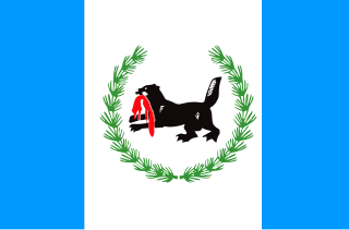
The flag of Irkutsk Oblast depicts three vertical stripes in the ratio 1:2:1: blue on the hoist and fly and white in the middle. Within the white strip, a stylized black tiger-beaver hybrid is seen holding a red sable in its mouth. These two are surrounded by branches of cedar. The blue represents the waters of Lake Baikal, while white represents purity, goodness, and honesty. The green of the cedar branches represents hope, joy, and abundance.
Lazarevo is a small town in Leninsky District in the Jewish Autonomous Oblast, Russia. It is the head of Lazarevskoye Rural Settlement.
Blagoslovennoye is a rural locality in Oktyabrsky District of the Jewish Autonomous Oblast, Russia. According to the 2010 Census, its population was 869.


