
Antigua and Barbuda is a sovereign island country in the West Indies. It lies at the juncture of the Caribbean Sea and the Atlantic Ocean in the Leeward Islands part of the Lesser Antilles, at 17°N latitude.

Barbuda is an island located in the eastern Caribbean forming part of the sovereign state of Antigua and Barbuda. It is located north of the island of Antigua and is part of the Leeward Islands of the West Indies. The island is a popular tourist destination because of its moderate climate and coastline.

Saint Philip is a civil parish of Antigua and Barbuda, on northeastern Antigua island. It had a population of 3,347 in 2011, which makes it the least populous parish of Antigua and Barbuda.
Saint Peter is a civil parish of Antigua and Barbuda, located on northeastern Antigua island. It had a population of 5,325 in 2011.

Antigua, also known as Waladli or Wadadli by the native population, is an island in the Lesser Antilles. It is one of the Leeward Islands in the Caribbean region and the most populous island of the country of Antigua and Barbuda. Antigua and Barbuda became an independent state within the Commonwealth of Nations on 1 November 1981.

All Saints is the second largest town in Antigua and Barbuda, with a population of 3,412. It is located in the middle of Antigua, at 17°3′N61°47′W. Just 5 miles NW of here is the capital, St. John's. It had a population of 3,900 in 2001.
Barbuda Codrington Airport is a public airport serving the village of Codrington, on the island of Barbuda. It has a very short runway.
Parham Town is a coastal town and port located in and capital of Saint Peter Parish on the island of Antigua, in Antigua and Barbuda. It had a population of 1,491 in 2001.
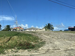
Codrington Lagoon is a long lagoon which takes up much of the west of the Caribbean island of Barbuda. Its access to the sea was once only via Cuffy Creek, at the northern tip of the lagoon, but in 2019 the western edge of the lagoon was destroyed by storms and the lagoon is now completely open to the sea. The water is shallow, and much of the shore of the northern half of the lagoon is marshland. The town of Codrington, the main settlement on the island, is located on the eastern shore of the lagoon.
Piggotts, also known as St Mark's Village, is a small township in Saint George Parish on Antigua island in Antigua and Barbuda. It had a population of 1,478 in 2001.
Potters Village is a township located on Antigua in Antigua and Barbuda. It is located in the north of the island, to the east of the capital, St. John's and southwest of Piggotts.
Bethesda is a township in Saint Paul Parish on the island of Antigua, in Antigua and Barbuda.

Antigua and Barbuda lie in the eastern arc of the Leeward Islands of the Lesser Antilles, separating the Atlantic Ocean from the Caribbean Sea. Antigua is 650 km (400 mi) southeast of Puerto Rico; Barbuda lies 48 km (30 mi) due north of Antigua, and the uninhabited island of Redonda is 56 km (35 mi) southwest of Antigua.
Afro-Antiguans and Afro-Barbudans are Antiguans and Barbudans of entirely or predominantly African ancestry.
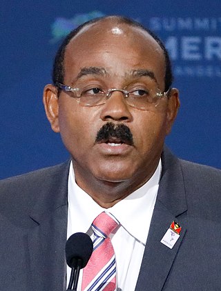
Gaston Alfonso Browne is an Antiguan politician serving as the prime minister of Antigua and Barbuda and leader of the Labour Party since 2014. Before entering politics, he was a banker and businessman.

Five Islands Village is a village located on the northwest coast of Antigua, within Saint John Parish in Antigua and Barbuda.
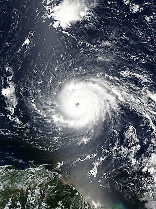
Hurricane Irma was an extremely powerful Cape Verde hurricane that caused widespread destruction across its path in September 2017. Irma was the first Category 5 hurricane to strike the Leeward Islands on record, followed by Maria two weeks later. At the time, it was considered the most powerful hurricane on record in the open Atlantic region, outside of the Caribbean Sea and Gulf of Mexico, until it was surpassed by Hurricane Dorian two years later. It was also the third-strongest Atlantic hurricane at landfall ever recorded, just behind the 1935 Labor Day Hurricane and Dorian.
The Barbuda Land Act of 2007 establishes that the citizens of Barbuda communally own the land. The act specifies that residents must provide consent for major development projects on the island. The Government of Antigua and Barbuda passed the act on January 17, 2008.

Squatting in the island country of Antigua and Barbuda in the West Indies is the occupation of unused land or derelict buildings without the permission of the owner. Historically, native Barbudans were seen as squatters and after Hurricane Irma in 2017, Prime Minister Gaston Browne offered people he termed squatters the chance to buy their land.
This article is about the demographic features of the population of Barbuda, including population density, internet access, crime rate, and other aspects of the population.
