
Para is a district of northern Suriname. Para's capital city is Onverwacht, with other towns including Paranam, and Zanderij. Para has a population of 24,700 and an area of 5,393 km2. The district is the mining and forestry centre of Suriname, with many large bauxite mining operations operating. The district is a mixture of forest and savannas.

Sipaliwini is the largest district of Suriname, located in the south. Sipaliwini is the only district that does not have a regional capital, as it is directly administered by the national government in Paramaribo. Sipaliwini District includes disputed areas, with the southwestern region controlled and administered by Guyana, whereas the southeastern region is controlled by French Guiana.
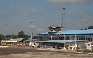
Johan Adolf Pengel International Airport, also known as Paramaribo-Zanderij International Airport, and locally referred to simply as JAP, is an airport located in the town of Zanderij and hub for airline carrier Surinam Airways, 45 kilometres (28 mi) south of Paramaribo. It is the larger of Suriname's two international airports, the other being Zorg en Hoop with scheduled flights to Guyana, and is operated by Airport Management, Ltd./ NV Luchthavenbeheer.

Brownsweg is a town and resort in Suriname in the Brokopondo District. Its population at the 2012 census was 4,793.
Rudi Kappel Airstrip is located 9 kilometres (5.6 mi) south of the Tafelberg tepui in Suriname. It was constructed as part of Operation Grasshopper. It used to be named Tafelberg Airstrip, but was renamed Rudi Kappel Airstrip, after the co-pilot of a flight that crashed near Vincent Fayks Airport on 6 October 1959.
Kabalebo Airstrip serves the village of Kabalebo, Suriname. It was constructed as part of Operation Grasshopper.
Käyser Airstrip, also Käyser Jan Gouka Airstrip is near the Käyser Mountains range in Sipaliwini District, Suriname. It was constructed as part of Operation Grasshopper and has one long grass runway. Fishing and wildlife tours are prime users of the airstrip.

Vincent Fajks Airstrip is an airstrip serving Paloemeu, Suriname. The airport was constructed as part of Operation Grasshopper. It was named after the Polish pilot Vincent Fajks who crashed with co-pilot Ronald Kappel with their Aero Commander AC 520 (PZ-TAG) airplane at the site in October 1959, while trying to deliver building materials for the airport. They both received a state funeral in Paramaribo on 11 October 1959. There is a jungle resort on the Tapanahony River near Paloemeu.
Sipaliwini Airstrip is an airstrip located near the village of Sipaliwini Savanna, in the most southern part of Suriname in the Sipaliwini District. It was constructed as part of Operation Grasshopper and the runway of the airstrip was publicly opened in 1962.

Kabalebo is a resort in Suriname, located in the Sipaliwini District. Its population at the 2012 census was 2,291.
Operation Grasshopper was a project to look for natural resources in Suriname from the air. For this project, seven airstrips were constructed in the interior of Suriname from 1959 onward.
Caricom Airways, which stands for Caribbean Commuter Airways, was a regional airline from the Caribbean, with the headquarters of the company at Paramaribo, Suriname. From the down-town Zorg en Hoop Airport in Suriname, Caricom Airways mainly flew charter flights to various destinations in the interior of Suriname, the Caribbean and Northern Brazil.
Oelemari Airstrip is an airstrip located near the Oelemari River in Suriname. This small grass airstrip was constructed as part of the Operation Grasshopper project in Suriname.

The Tigri Area or New River Triangle is a forested area in the East Berbice-Corentyne region of Guyana that has been disputed by Suriname since the 19th century. In Suriname, it is seen as an integral part of the Coeroeni Resort located in the Sipaliwini District.
Avanavero Airstrip, near Avanavero, Suriname. It was one of the airstrips constructed in the aftermath of Operation Grasshopper.
The Luchtvaartdienst Suriname is the Civil Aviation Department of the Suriname Ministry of Transport, Communication and Tourism. It is responsible for the regulation of all aviation activities in the country, and ensures that all activities are carried out in compliance with international standards. It is a member of the International Civil Aviation Organization (ICAO).
Kuruni is a village in the Coeroeni resort in the Sipaliwini District of Suriname. The village is inhabited by indigenous people of the Tiriyó tribe. The inhabitants are of the subgroup Aramayana or the Bee people.
Camp Tigri or Camp Jaguar is a military camp and airstrip located in the Tigri Area. The area is disputed between Suriname and Guyana.

Ronald "Rudi" Elwin Kappel was a Surinamese pilot. He was one of the founders of Luchtvaartbedrijf Kappel-Van Eyck which is now called Surinam Airways, the first airline in Suriname. He also helped construct the Zorg en Hoop Airport, and the Rudi Kappel Airstrip. Kappel died in an air crash near Paloemeu.

