
Kootenai County is located in the U.S. state of Idaho. As of the 2020 census, its population was 171,362, making it the third-most populous county in Idaho and the largest in North Idaho, the county accounting for 45.4% of the region's total population. The county seat and largest city is Coeur d'Alene. The county was established in 1864 and named after the Kootenai tribe. Kootenai County is coterminous with the Coeur d'Alene metropolitan area, which along with the Spokane metropolitan area comprises the Spokane–Coeur d'Alene combined statistical area.

Benewah County is a county located in the northwest part of the U.S. state of Idaho. As of the 2020 United States Census the county had a population of 9,530. The county seat and largest city is St. Maries, which has some area inside the Coeur d'Alene Reservation. The county was established on January 23, 1915, of land partitioned from Kootenai County. It was named for a chief of the Coeur d'Alene Tribe. The federally recognized Coeur d'Alene Tribe is based on the Coeur d'Alene Reservation in this and neighboring Kootenai County.

Coeur d'Alene is a city and the county seat of Kootenai County, Idaho, United States. It is the most populous city in North Idaho and the principal city of the Coeur d'Alene Metropolitan Statistical Area. The population was 54,628 at the 2020 census. Coeur d'Alene is a satellite city of Spokane, which is located about thirty miles (50 km) to the west in the state of Washington. The two cities are the key components of the Spokane–Coeur d'Alene Combined Statistical Area, of which Coeur d'Alene is the third-largest city. The city is situated on the north shore of the 25-mile (40 km) long Lake Coeur d'Alene and to the west of the Coeur d'Alene Mountains. Locally, Coeur d'Alene is known as the "Lake City", or simply called by its initials, "CDA".

Hayden is a city in Kootenai County, Idaho, United States. Located in the northern portion of the state, it is a suburb of nearby Coeur d'Alene and its population was 15,570 at the 2020 census.

The L'Anse Indian Reservation is the land base of the federally recognized Keweenaw Bay Indian Community of the historic Lake Superior Band of Chippewa Indians.. The reservation is located primarily in two non-contiguous sections on either side of the Keweenaw Bay in Baraga County in the Upper Peninsula of the U.S. state of Michigan. The Keweenaw Bay Community also manages the separate Ontonagon Indian Reservation.

The Coeur d'Alene Tribe are a Native American tribe and one of five federally recognized tribes in the state of Idaho. The Coeur d'Alene have sovereign control of their Coeur d'Alene Reservation, which includes a significant portion of Lake Coeur d'Alene and its submerged lands.

The Pend d'Oreille or Pend d'Oreilles, also known as the Kalispel, are Indigenous peoples of the Northwest Plateau. Today many of them live in Montana and eastern Washington of the United States. The Kalispel peoples referred to their primary tribal range as Kaniksu.
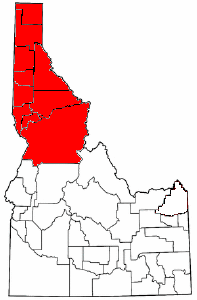
The Idaho panhandle—locally known as North Idaho, Northern Idaho, or simply the Panhandle—is a salient region of the U.S. state of Idaho encompassing the state's 10 northernmost counties: Benewah, Bonner, Boundary, Clearwater, Idaho, Kootenai, Latah, Lewis, Nez Perce, and Shoshone. The panhandle is bordered by the state of Washington to the west, Montana to the east, and the Canadian province of British Columbia to the north. The Idaho panhandle, along with Eastern Washington, makes up the region known as the Inland Northwest, headed by its largest city, Spokane, Washington.

The Bad River LaPointe Band of the Lake Superior Tribe of Chippewa Indians or Bad River Tribe for short are a federally recognized tribe of Ojibwe people. The tribe had 6,945 members as of 2010. The Bad River Reservation is located on the south shore of Lake Superior and has a land area of about 193.11 square miles (500.15 km2) in northern Wisconsin, straddling Ashland and Iron Counties. Odanah, the administrative and cultural center, is located 5 miles (8 km) east of the town of Ashland on U.S. Highway 2. The reservation population was 1,545 in 2020. Most of the reservation is managed as undeveloped forest and wetland, providing a habitat for wild rice and other natural resources.

Lake Pend Oreille in the northern Idaho Panhandle is the largest lake in the U.S. state of Idaho and the 38th-largest lake by area in the United States, with a surface area of 148 square miles (380 km2). It is 69 kilometres (43 mi) long, and 1,152 feet (351 m) deep in some regions, making it the fifth-deepest in the nation and having a volume of 43,939,940 acre feet = 54 km3. The lake is fed by the Clark Fork River and the Pack River, and drains into the Pend Oreille River, as well as subsurfacely into the Spokane Valley–Rathdrum Prairie Aquifer. It is surrounded by national forests and a few small towns, with the largest population on the lake at Sandpoint. The majority of the shoreline is non-populated and all but the southern tip of the lake is in Bonner County. The southern tip is in Kootenai County and is home to Farragut State Park, formerly the Farragut Naval Training Station during World War II, of which a small part is still active and conducts U.S. Navy acoustic underwater submarine research.
The Pyramid Lake Paiute Tribe Reservation is a United States reservation in northwestern Nevada, approximately 35 miles (56 km) northeast of Reno, in Washoe, Storey, and Lyon counties.
Bois Forte Indian Reservation is an Indian reservation formed for the Bois Forte Band of Chippewa.

Coeur d'Alene Lake, officially Coeur d'Alene Lake, is a natural dam-controlled lake in North Idaho, located in the Pacific Northwest region of the United States. At its northern end is the city of Coeur d'Alene. It spans 25 miles (40 km) in length and ranges from 1 to 3 miles (5 km) wide with over 109 miles (175 km) of shoreline.

The Kootenai Tribe of Idaho is a federally recognized tribe of Lower Kootenai people. They are an Indigenous people of the Northwest Plateau based in northern Idaho.

The Duck Valley Indian Reservation was established in the 19th century for the federally recognized Shoshone-Paiute Tribe. It is isolated in the high desert of the western United States, and lies on the state line, the 42nd parallel, between Idaho and Nevada.

The Saint Joe River is a 140-mile (225 km) long tributary of Coeur d'Alene Lake in northern Idaho. Beginning at an elevation of 6,487 feet (1,977 m) in the Northern Bitterroot Range of eastern Shoshone County, it flows generally west through the Saint Joe River Valley and the communities of Avery and Calder. Past Calder, it flows into Benewah County and through the town of St. Maries, where it receives its largest tributary, the Saint Maries River. It then turns northwest, passing through Heyburn State Park before reaching its mouth just north of the Kootenai County line. Much of the river's route through Heyburn State Park is partially flooded due to raised water levels from the Washington Water Power dam at Post Falls on the Spokane River below Coeur d'Alene Lake. With a mouth elevation of 2,129 feet (649 m), it is claimed to be the highest navigable river in the world.

Heyburn State Park is a public recreation area in the U.S. state of Idaho. It is located almost entirely in Benewah County, with a small portion extending into southern Kootenai County. The park was founded in 1908 and is the oldest state or provincial park in the Pacific Northwest. The park has 5,744 acres (23.2 km2) of land and 2,332 acres (9.4 km2) of water on three lakes: Benewah, Chatcolet, and Hidden. A dam constructed on the Spokane River in Post Falls in 1906 raised the level of Lake Coeur d'Alene, connecting it to the park's three lakes. The surface elevation of the lakes is 2,125 feet (648 m) above sea level. The park's year-round recreational opportunities include camping, boating, hiking, horseback riding, fishing, and picnicking.
Coeur d'Alene River Wildlife Management Area at 5,799 acres (23.47 km2) is an Idaho wildlife management area primarily in Kooteani County but also in Benewah County. The majority of the WMA is located in the Thompson Lake Segment along the Coeur d'Alene River, but portions are also located along the St. Joe River in the upper sections of Lake Coeur d'Alene near Heyburn State Park. Land acquisition for the WMA began in 1964.
Idaho v. United States, 533 U.S. 262 (2001), was a United States Supreme Court case in which the Court held that the United States, not the state of Idaho, held title to lands submerged under Lake Coeur d'Alene and the St. Joe River, and that the land was held in trust for the Coeur d'Alene Tribe as part of its reservation, and in recognition of the importance of traditional tribal uses of these areas for basic food and other needs.


