
Latah County is a county located in the north central region of the U.S. state of Idaho. As of the 2020 census, the population was 39,517. The county seat and largest city is Moscow, the home of the University of Idaho, the state's flagship university.

Kootenai County is located in the U.S. state of Idaho. As of the 2020 census, its population was 171,362, making it the third-most populous county in Idaho and the largest in North Idaho, the county accounting for 45.4% of the region's total population. The county seat and largest city is Coeur d'Alene. The county was established in 1864 and named after the Kootenai tribe.

Boundary County is the northernmost county of the U.S. state of Idaho. As of the 2020 census, the population was 12,056. The county seat and largest city is Bonners Ferry.
Bonner County is a county in the northern part of the U.S. state of Idaho. As of the 2020 census, the population was 47,110. The county seat and largest city is Sandpoint. Partitioned from Kootenai County and established in 1907, it was named for Edwin L. Bonner, a ferry operator.

Benewah County is a county located in the northwest part of the U.S. state of Idaho. As of the 2020 United States Census the county had a population of 9,530. The county seat and largest city is St. Maries, which has some area inside the Coeur d'Alene Reservation.

Post Falls is a city in Kootenai County, Idaho, United States. It is the gateway city to North Idaho on I-90 just west of Coeur d'Alene and east of Spokane, Washington. The population was 38,485 at the 2020 census, making it Idaho's ninth-largest city and the second largest city in North Idaho behind Coeur d’Alene.

Pocatello is the county seat and largest city of Bannock County, with a small portion on the Fort Hall Indian Reservation in neighboring Power County, containing the city's airport. It is the principal city of the Pocatello metropolitan area, which encompasses all of Bannock County in the southeastern part of the U.S. state of Idaho.

Blackfoot is a city and county seat of Bingham County, Idaho, United States. The population was 12,346 at the 2020 census. Blackfoot is the principal city of the Blackfoot, Idaho, Micropolitan Statistical Area, which includes Bingham County.

Sandpoint is the largest city in, and the county seat of, Bonner County, Idaho, United States. Its population was 9,777 as of the 2022 census.

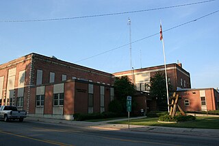
Bonners Ferry is the larger city in and the county seat of Boundary County, Idaho, United States. The population was 2,543 at the 2010 census.

Coeur d'Alene is a city and the county seat of Kootenai County, Idaho, United States. It is the most populous city in North Idaho and the principal city of the Coeur d'Alene Metropolitan Statistical Area. The population was 54,628 at the 2020 census. Coeur d'Alene is a satellite city of Spokane, which is located about thirty miles (50 km) to the west in the state of Washington. The two cities are the key components of the Spokane–Coeur d'Alene Combined Statistical Area, of which Coeur d'Alene is the third-largest city. The city is situated on the north shore of the 25-mile (40 km) long Lake Coeur d'Alene and to the west of the Coeur d'Alene Mountains. Locally, Coeur d'Alene is known as the "Lake City," or simply called by its initials, "CDA."

Rathdrum is a city in Kootenai County, Idaho, United States. The population was 6,826 at the 2010 census, up from 4,816 in 2000. It is part of the Coeur d'Alene Metropolitan Statistical Area, which includes the entire county. It is named after Rathdrum, a village in County Wicklow, Ireland.
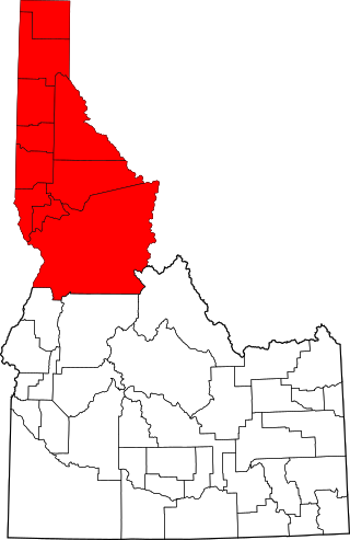
The Idaho panhandle—locally known as North Idaho, Northern Idaho, or simply the Panhandle—is a salient region of the U.S. state of Idaho encompassing the state's 10 northernmost counties: Benewah, Bonner, Boundary, Clearwater, Idaho, Kootenai, Latah, Lewis, Nez Perce, and Shoshone. The panhandle is bordered by the state of Washington to the west, Montana to the east, and the Canadian province of British Columbia to the north. The Idaho panhandle, along with Eastern Washington, makes up the region known as the Inland Northwest, headed by its largest city, Spokane, Washington.

Lake Pend Oreille in the northern Idaho Panhandle is the largest lake in the U.S. state of Idaho and the 38th-largest lake by area in the United States, with a surface area of 148 square miles (380 km2). It is 69 kilometres (43 mi) long, and 1,152 feet (351 m) deep in some regions, making it the fifth-deepest in the nation and having a volume of 43,939,940 acre feet = 54 km3. The lake is fed by the Clark Fork River and the Pack River, and drains into the Pend Oreille River, as well as subsurfacely into the Spokane Valley–Rathdrum Prairie Aquifer. It is surrounded by national forests and a few small towns, with the largest population on the lake at Sandpoint. The majority of the shoreline is non-populated and all but the southern tip of the lake is in Bonner County. The southern tip is in Kootenai County and is home to Farragut State Park, formerly the Farragut Naval Training Station during World War II, of which a small part is still active and conducts U.S. Navy acoustic underwater submarine research.

The Idaho Republican Party (IDGOP) is the Idaho state affiliate of the United States Republican Party, headquartered in Boise. It is currently the dominant party in the state, controlling both of Idaho's U.S. House seats, both U.S. Senate seats, the governorship, and has supermajorities in both houses of the state legislature.

Edgar Wilson was a United States Representative from Idaho.
Lakeland High School is a four-year public secondary school in Rathdrum, Idaho, one of two traditional high schools in the Lakeland Joint School District #272 of northern Kootenai County. The current campus opened in 1979 as a senior high school(grades 10–12); The two high schools of Rathdrum and Spirit Lake camp together to form Lakeland High School in the fall of 1961. The campus located at the now Lakeland Middle School was built in 1962 and was moved into as soon as it was completed. In 1979, that building became the junior high school. The school colors are green and gold and the mascot is a hawk. Even though Rathdrum is a small city, many people attend Lakeland High School.

State Highway 41 (SH-41) is a state highway mostly in the U.S. state of Idaho. It runs from Interstate 90 in Post Falls to U.S. Route 2 on the Washington state line. The northernmost 0.41 miles (0.66 km) of SH-41 run along State Street along the state line, with the southbound lane in the town of Newport, Washington, and the northbound lane in Oldtown, Idaho. The part of the highway in Washington is designated State Route 41 (SR 41).

State Highway 53 (SH-53) is a 14.240-mile-long (22.917 km) state highway serving Kootenai County in the U.S. state of Idaho. SH-53 travels northeast from Washington State Route 290 at the Washington state border near Hauser to a short concurrency with SH-41 in Rathdrum. From Rathdrum, the highway continues east to end at U.S. Route 95 (US-95) north of Hayden. The Hauser to Rathdrum segment first appeared on a map in 1926, while the continuation of the route to the Hayden area appeared in 1937, completing an unnumbered state highway. SH-53 was designated in 1953 after all unnumbered state highways were assigned numbers.

The Rathdrum Prairie is a flat in the U.S. state of Idaho. The prairie contains the cities of Coeur d'Alene, Post Falls, Hayden, Rathdrum, State Line, and Huetter. The prairie also contains part of the Spokane Valley–Rathdrum Prairie Aquifer.


