
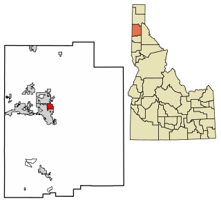
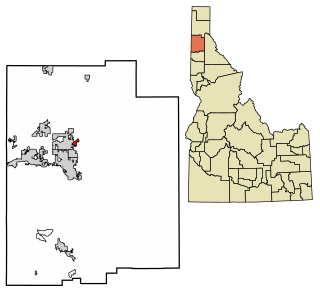
Kootenai County is located in the U.S. state of Idaho. As of the 2020 census, its population was 171,362, making it the third-most populous county in Idaho and the largest in North Idaho, the county accounting for 45.4% of the region's total population. The county seat and largest city is Coeur d'Alene. The county was established in 1864 and named after the Kootenai tribe. Kootenai County is coterminous with the Coeur d'Alene metropolitan area, which along with the Spokane metropolitan area comprises the Spokane–Coeur d'Alene combined statistical area.
Bonner County is a county in the northern part of the U.S. state of Idaho. As of the 2020 census, the population was 47,110. The county seat and largest city is Sandpoint. Partitioned from Kootenai County and established in 1907, it was named for Edwin L. Bonner, a ferry operator. Bonner County comprises the Sandpoint, Idaho Micropolitan Statistical Area.

Post Falls is a city in Kootenai County, Idaho, United States. It is the gateway city to Northern Idaho off of Interstate 90, just west of Coeur d'Alene, and east of Spokane, Washington. The population was 38,485 at the 2020 census, making it Idaho's ninth-largest city and the second largest city in North Idaho behind Coeur d’Alene.
Plummer is a city in Benewah County, Idaho, United States. The population was 1,044 at the 2010 census, up from 990 in 2000. It is the largest city within the Coeur d'Alene Reservation, and is accessed by U.S. Route 95, the state's primary north–south highway.

Tensed is a city in Benewah County, Idaho, United States. The population was 123 at the 2010 census, down from 126 in 2000. The city is within the Coeur d'Alene Reservation, and is accessed by U.S. Route 95, the state's primary north-south highway. The city is located about 1 mile (0.6 km) from the north entrance of McCroskey State Park.
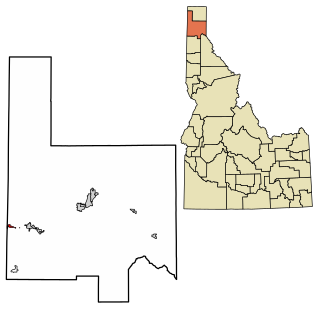
Oldtown is a city in Bonner County, Idaho and suburb of Newport, Washington, with a population of 184 at the 2010 census. It is located on the Pend Oreille River, just east of Newport. There are no natural or physical barriers, and it is strictly a political division, separated by the straight-line state boundary. Oldtown is squeezed between this boundary to the west and the river to the east, leaving the main business district on U.S. Route 2 with only 700 feet of space in which to operate on the Idaho side. Many homes are located in the south end on the other side of the railroad, as the Pend Oreille is somewhat further away here.

White Bird is a city in Idaho County, Idaho. The population was 91 at the time of the 2010 census, down from 106 in 2000.

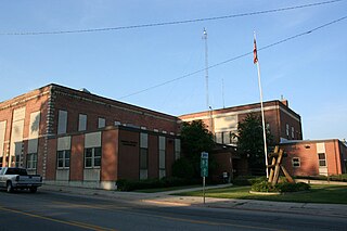
Athol ( AH-thol; is a city in Kootenai County, Idaho, United States. The population was 709 at the 2020 census, up from 692 in the 2010 census. It is part of the Coeur d'Alene Metropolitan Statistical Area, which includes the entire county. Its main attraction is Silverwood Theme Park.
Dalton Gardens is a city in Kootenai County, Idaho, United States. It is considered a suburb of Coeur d'Alene and borders the city to the north and east. The city of Dalton Gardens is also part of the larger Spokane-Coeur d'Alene Combined Metropolitan Statistical Area which encompasses Kootenai County, Idaho. The population of Dalton Gardens was 2,335 at the time of the 2010 census.

Harrison is a city in Kootenai County, Idaho, United States. The population was 203 at the 2010 census. Harrison is located on the eastern shore of Lake Coeur d'Alene, immediately south of where the Coeur d'Alene River flows into the lake.

Hauser is a city in Kootenai County, Idaho, United States. The population was 678 at the 2010 census. The city is located on the southern end of Hauser Lake.

Hayden is a city in Kootenai County, Idaho, United States. Located in the northern portion of the state, it is a suburb of nearby Coeur d'Alene and its population was 15,570 at the 2020 census.
Hayden Lake is a city in Kootenai County, Idaho, United States. Located in the northern portion of the state, it is considered a suburb of the city of Coeur d'Alene. Its population was 574 at the 2010 census. The city was named after the nearby Lake Hayden, which is now more commonly also known as Hayden Lake, after the city.
Spirit Lake is a city in Kootenai County, Idaho. The population was 1,945 at the time of the 2010 census, up from 1,376 in 2000. It is part of the Coeur d'Alene Metropolitan Statistical Area, which includes the entire county.

Worley is a city in southwestern Kootenai County, Idaho, United States. The population was 257 at the 2010 census, up from 223 in 2000. The city is within the Coeur d'Alene Indian Reservation.

Kellogg is a city in the Silver Valley of Shoshone County, Idaho, United States, in the Idaho Panhandle region. The city lies near the Coeur d'Alene National Forest and about 36 miles (58 km) east-southeast of Coeur d'Alene along Interstate 90. As of the 2010 United States Census, the city had a total population of 2,120, down by a third from its population in 1980.

Mullan is a city in the northwest United States, located in the Silver Valley mining district of northern Idaho. The population was 646 at the 2020 census and 692 at the 2010 census, and 840 in 2000.

Osburn is a city in Shoshone County, Idaho, United States. Located in the Silver Valley mining region of northern Idaho, its population was 1,555 at the 2010 census.

Wardner is a city in Shoshone County, Idaho, United States. Located in the Silver Valley mining region, the population was 188 at the 2010 census, down from 215 in 2000.

Liberty Lake is a city in Spokane County, Washington, United States, located adjacent to the eponymous lake. Located just over a mile west of the Washington–Idaho border, Liberty Lake is both a suburb of Spokane, Washington and a bedroom community to Coeur d'Alene, Idaho. The population was 12,003 at the 2020 census.


