
Kootenai County is located in the U.S. state of Idaho. As of the 2020 census, its population was 171,362, making it the third-most populous county in Idaho and the largest in North Idaho, the county accounting for 45.4% of the region's total population. The county seat and largest city is Coeur d'Alene. The county was established in 1864 and named after the Kootenai tribe. Kootenai County is coterminous with the Coeur d'Alene metropolitan area, which along with the Spokane metropolitan area comprises the Spokane–Coeur d'Alene combined statistical area.

Parkline is a census-designated place on the Coeur d'Alene Reservation in Benewah County, Idaho, United States. The population was 80 at the 2010 census. Parkline was a city until it disincorporated in 2001.

Coeur d'Alene is a city and the county seat of Kootenai County, Idaho, United States. It is the most populous city in North Idaho and the principal city of the Coeur d'Alene Metropolitan Statistical Area. The population was 54,628 at the 2020 census. Coeur d'Alene is a satellite city of Spokane, which is located about thirty miles (50 km) to the west in the state of Washington. The two cities are the key components of the Spokane–Coeur d'Alene Combined Statistical Area, of which Coeur d'Alene is the third-largest city. The city is situated on the north shore of the 25-mile (40 km) long Lake Coeur d'Alene and to the west of the Coeur d'Alene Mountains. Locally, Coeur d'Alene is known as the "Lake City", or simply called by its initials, "CDA".

Hayden is a city in Kootenai County, Idaho, United States. Located in the northern portion of the state, it is a suburb of nearby Coeur d'Alene and its population was 15,570 at the 2020 census.
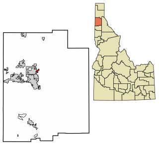
Hayden Lake is a city in Kootenai County, Idaho, United States. Located in the northern portion of the state, it is considered a suburb of the city of Coeur d'Alene. Its population was 574 at the 2010 census. The city was named after the nearby Lake Hayden, which is now more commonly also known as Hayden Lake, after the city.
The Inland Northwest, historically and alternatively known as the Inland Empire, is a region of the American Northwest centered on the Greater Spokane, Washington Area, encompassing all of Eastern Washington and North Idaho. Under broader definitions, Northeastern Oregon and Western Montana may be included in the Inland Northwest. Alternatively, stricter definitions may exclude Central Washington and Idaho County, Idaho.

The Coeur d'Alene Tribe are a Native American tribe and one of five federally recognized tribes in the state of Idaho. The Coeur d'Alene have sovereign control of their Coeur d'Alene Reservation, which includes a significant portion of Lake Coeur d'Alene and its submerged lands.

The Coeur d'Alene Reservation is a Native American reservation in northwestern Idaho, United States. It is home to the federally recognized Coeur d'Alene, one of the five federally recognized tribes in the state.
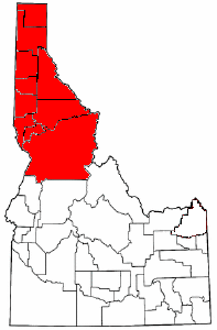
The Idaho panhandle—locally known as North Idaho, Northern Idaho, or simply the Panhandle—is a salient region of the U.S. state of Idaho encompassing the state's 10 northernmost counties: Benewah, Bonner, Boundary, Clearwater, Idaho, Kootenai, Latah, Lewis, Nez Perce, and Shoshone. The panhandle is bordered by the state of Washington to the west, Montana to the east, and the Canadian province of British Columbia to the north. The Idaho panhandle, along with Eastern Washington, makes up the region known as the Inland Northwest, headed by its largest city, Spokane, Washington.

Coeur d'Alene Lake, officially Coeur d'Alene Lake, is a natural dam-controlled lake in North Idaho, located in the Pacific Northwest region of the United States. At its northern end is the city of Coeur d'Alene. It spans 25 miles (40 km) in length and ranges from 1 to 3 miles (5 km) wide with over 109 miles (175 km) of shoreline.

The Idaho Panhandle National Forests are a jointly administered set of three national forests located mostly in the U.S. state of Idaho. In 1973, major portions of the Kaniksu, Coeur d'Alene, and St. Joe National Forests were combined to be administratively managed as the Idaho Panhandle National Forests (IPNF). The IPNF consists of more than 2.5 million acres (10,000 km2) of public lands in the panhandle of north Idaho, with small areas extending into eastern Washington (4.7%) and western Montana (1.2%). The northernmost portion of the IPNF share a boundary with Canada. The Forest Supervisor's office is located in Coeur d'Alene, Idaho with district office's in Bonners Ferry, Sandpoint, Priest River, Fernan and Smelterville, and St. Maries and Avery.

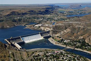
The Coeur d'Alene River flows 37 miles (60 km) from the Silver Valley into Lake Coeur d'Alene in the U.S. state of Idaho. The stream continues out of Lake Coeur d'Alene as the Spokane River.

Interstate 90 (I-90) is a transcontinental Interstate Highway that runs east–west across the northern United States. Within the state of Idaho, the freeway travels for 74 miles (119 km) from the Washington border near Spokane to Coeur d'Alene and the panhandle region at the north end of the state. After traveling through the Silver Valley along the Coeur d'Alene River in the Bitterroot Range, I-90 crosses into Montana at Lookout Pass.

Coeur d'Alene's Old Mission State Park is heritage-oriented in the western United States in northern Idaho, preserving the Mission of the Sacred Heart, or Cataldo Mission, a national historic landmark. The park contains the church itself, the parish house, and the surrounding property. Built in 1850–1853, Mission of the Sacred Heart is the oldest standing building in Idaho. It was designated a National Historic Landmark in 1961, and put on the National Register of Historic Places in 1966.

Heyburn State Park is a public recreation area in the U.S. state of Idaho. It is located almost entirely in Benewah County, with a small portion extending into southern Kootenai County. The park was founded in 1908 and is the oldest state or provincial park in the Pacific Northwest. The park has 5,744 acres (23.2 km2) of land and 2,332 acres (9.4 km2) of water on three lakes: Benewah, Chatcolet, and Hidden. A dam constructed on the Spokane River in Post Falls in 1906 raised the level of Lake Coeur d'Alene, connecting it to the park's three lakes. The surface elevation of the lakes is 2,125 feet (648 m) above sea level. The park's year-round recreational opportunities include camping, boating, hiking, horseback riding, fishing, and picnicking.

De Smetdə SMET or dez-MET; is a census-designated place on the Coeur d'Alene Reservation in Benewah County, Idaho, United States.
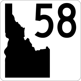
State Highway 58 (SH-58) is a 3-mile (4.8 km) state highway in Kootenai County in the Idaho Panhandle of Idaho, United States. It connects Washington State Route 278 with U.S. Route 95 (US 95) and west of Worley. The highway is maintained by the Idaho Transportation Department and lies entirely within the Coeur d'Alene Reservation.

Spokane–Coeur d'Alene combined statistical area, officially the Spokane–Spokane Valley–Coeur d'Alene, WA–ID CSA as defined by the United States Census Bureau, is a combined statistical area that comprises the Spokane metropolitan area and the Coeur d'Alene metropolitan area. The population was 785,302 as of 2023. It is the 70th largest Combined Statistical Area in the United States, and is the economic and cultural center of the Inland Northwest. The CSA is anchored by Spokane and its largest satellite, Coeur d'Alene, which are separated by suburbs that largely follow the path of the Spokane Valley and Rathdrum Prairie.

The Spokane–Spokane Valley Metropolitan Statistical Area, as defined by the United States Census Bureau, is an area consisting of Spokane and Stevens counties in Washington state, anchored by the city of Spokane and its largest suburb, Spokane Valley. As of July 1, 2021, the MSA had an estimated population of 593,466. The Spokane Metropolitan Area and the neighboring Coeur d'Alene metropolitan area, make up the larger Spokane–Coeur d'Alene combined statistical area. The urban areas of the two MSAs largely follow the path of Interstate 90 between Spokane and Coeur d'Alene. In 2010, the Spokane–Spokane Valley MSA had a gross metropolitan product of $20.413 billion.

State Highway 97 (SH-97) is a state highway in Kootenai County, Idaho. The highway runs for 35.745 miles (57.526 km) from State Highway 3 to Interstate 90 (I-90) along the east side of Lake Coeur d'Alene, passing through the community of Harrison. The entire highway is designated as the Lake Coeur d'Alene Scenic Byway.


