Coffee Creek | |
---|---|
Coordinates: 41°5′1″N122°42′48″W / 41.08361°N 122.71333°W | |
Country | United States |
State | California |
County | Trinity County |
Area | |
• Total | 11.54 sq mi (29.88 km2) |
• Land | 11.52 sq mi (29.83 km2) |
• Water | 0.02 sq mi (0.05 km2) 0.16% |
Elevation | 3,068 ft (935 m) |
Population (2020) | |
• Total | 152 |
• Density | 13.20/sq mi (5.09/km2) |
Time zone | UTC-8 (Pacific (PST)) |
• Summer (DST) | UTC-7 (PDT) |
ZIP Code | 96091 |
Area code | 530 |
FIPS code | 06-14406 |
U.S. Geological Survey Geographic Names Information System: Coffee Creek, California |
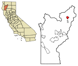
Coffee Creek is a census-designated place located within Trinity County in the U.S. state of California. [2] It is located just north of where Coffee Creek flows into the Trinity River along Highway 3 and is the most northern community in Trinity County. It contains the Coffee Creek elementary school. Coffee Creek Road originates at Highway 3 offering access to the interior of the Trinity Alps; the road is 20 miles long, dirt and only for high clearance vehicles. Coffee Creek sits at an elevation of 2,495 feet (760 m). [2] Its population is 152 as of the 2020 census, down from 217 from the 2010 census.
According to the United States Census Bureau, the CDP covers an area of 11.5 square miles (29.9 km2), 99.84% of it land and 0.16% of it water.
Census | Pop. | Note | %± |
---|---|---|---|
2020 | 152 | — | |
U.S. Decennial Census [3] 1850–1870 [4] [5] 1880-1890 [6] 1900 [7] 1910 [8] 1920 [9] 1930 [10] 1940 [11] 1950 [12] 1960 [13] 1970 [14] 1980 [15] 1990 [16] 2000 [17] 2010 [18] |
The 2010 United States Census [19] reported that Coffee Creek had a population of 217. The population density was 18.8 people per square mile (7.3/km2). The racial makeup of Coffee Creek was 198 (91.2%) White, 0 (0.0%) African American, 5 (2.3%) Native American, 5 (2.3%) Asian, 0 (0.0%) Pacific Islander, 3 (1.4%) from other races, and 6 (2.8%) from two or more races. Hispanic or Latino of any race were 16 persons (7.4%).
The Census reported that 186 people (85.7% of the population) lived in households, 31 (14.3%) lived in non-institutionalized group quarters, and 0 (0%) were institutionalized.
There were 85 households, out of which 16 (18.8%) had children under the age of 18 living in them, 48 (56.5%) were opposite-sex married couples living together, 3 (3.5%) had a female householder with no husband present, 4 (4.7%) had a male householder with no wife present. There were 3 (3.5%) unmarried opposite-sex partnerships, and 0 (0%) same-sex married couples or partnerships. 27 households (31.8%) were made up of individuals, and 14 (16.5%) had someone living alone who was 65 years of age or older. The average household size was 2.19. There were 55 families (64.7% of all households); the average family size was 2.75.
The population was spread out, with 32 people (14.7%) under the age of 18, 10 people (4.6%) aged 18 to 24, 37 people (17.1%) aged 25 to 44, 84 people (38.7%) aged 45 to 64, and 54 people (24.9%) who were 65 years of age or older. The median age was 50.2 years. For every 100 females, there were 102.8 males. For every 100 females age 18 and over, there were 117.6 males.
There were 152 housing units at an average density of 13.2 per square mile (5.1/km2), of which 67 (78.8%) were owner-occupied, and 18 (21.2%) were occupied by renters. The homeowner vacancy rate was 1.5%; the rental vacancy rate was 10.0%. 151 people (69.6% of the population) lived in owner-occupied housing units and 35 people (16.1%) lived in rental housing units.
In the state legislature, Coffee Creek is in the 2nd Senate District , represented by Democrat Mike McGuire, [20] and the 2nd Assembly District , represented by Democrat Jim Wood. [21]
Federally, Coffee Creek is in California's 2nd congressional district , represented by Democrat Jared Huffman. [22]
Arbuckle is a census-designated place (CDP) in Colusa County, California, United States. The population was 3,028 at the 2010 census, up from 2,332 at the 2000 census. Arbuckle is situated in the southerly portion of Colusa County, approximately 20 miles (32 km) southwest of the City of Colusa, the county seat. The town is characterized by single-family residences, multiple-family units, some mobile homes, and commercial activities. Land surrounding Arbuckle is agriculture including cultivated annual crops, and both active and unmaintained orchards. Various almond hullers may be found near the area. Regional access is provided by the north–south running Interstate 5, along with Old Highway 99 West running alongside Interstate 5.
Auberry is a census-designated place (CDP) in Fresno County, California, United States. The population was 2,369 at the 2010 census, up from 2,053 at the 2000 census. Auberry is located on Little Sandy Creek 9.5 miles (15 km) west of Shaver Lake Heights, at an elevation of 2,018 feet (615 m).
Cantua Creek is a census-designated place (CDP) in Fresno County, California, United States. As of the 2010 census, the population was 466, down from the 655 reported at the 2000 census. Cantua Creek is located 11 miles (18 km) south-southwest of Tranquillity, at an elevation of 295 feet.
Bayview is a census-designated place (CDP) located adjacent to the City of Eureka in Humboldt County, California, United States. Its population is 2,619 as of the 2020 census, up from 2,510 from the 2010 census. Many locals consider this area as part of "Pine Hill."
Covelo is a census-designated place (CDP) in Mendocino County, California, United States. Covelo is located 14 miles (23 km) east-northeast of Laytonville, at an elevation of 1,398 feet (426 m). The population was 1,394 at the 2020 census, up from 1,255 at the 2010 census. 405 acres (1.64 km2) of Covelo is part of the Round Valley Indian Reservation.
Corralitos is a census-designated place (CDP) in Santa Cruz County, California, United States. It is a rural area known for its agriculture of apples and strawberries, and its notable Corralitos Market and Sausage Co. Moreover, its location near the Pacific Ocean optimizes viticulture.
Albion is a census-designated place in Mendocino County, California, United States. It is located 15 miles (24 km) south of Fort Bragg, at an elevation of 174 feet (53 m). Albion had a population of 153 at the 2020 census.
Bodega is an unincorporated community and census-designated place (CDP) in Sonoma County in the U.S. state of California. The town had a population of 220 as of the 2010 Census.
Cazadero is an unincorporated community and census-designated place (CDP) in western Sonoma County, California, United States with a population of 354 in 2010. The downtown of Cazadero consists of two churches, a general store, a post office, a hardware store, an auto repair garage, private office space, and the Cazadero Volunteer Fire Department.
Coulterville is a census-designated place in Mariposa County, California, United States. It is located on Maxwell Creek 20 miles (32 km) northwest of Mariposa, at an elevation of 1,699 feet (518 m). Coulterville had a population of 115 at the 2020 census, down from 201 at the 2010 census, when the CDP covered a much greater area. It is a mining town located in the foothills of the Sierra Nevada. The ZIP Code is 95311. The community is inside area code 209.
Big Creek is a small census-designated place in Fresno County, California, located in the Sierra Nevada on the north bank of Big Creek. It lies at an elevation of 4,984 feet (1,519 m) above sea level. Its last population count was 175. The ZIP code is 93605, and the community is inside area code 559.
Burnt Ranch is a census-designated place (CDP) in Trinity County, California. It has a school and a post office. Its ZIP Code is 95527, and it is in area code 530. Its elevation is 1,502 feet (458 m). Its population is 250 as of the 2020 census, down from 281 from the 2010 census.
Big Lagoon is a census-designated place in Humboldt County, California. It is located 7 miles (11 km) north of Trinidad, at an elevation of 56 feet (17 m). Its population is 161 as of the 2020 census, up from 93 from the 2010 census.
Clear Creek is a census-designated place (CDP) in Lassen County, California. It is located 2.5 miles (4 km) west-southwest of Westwood, at an elevation of 4970 feet. Its population is 175 as of the 2020 census, up from 169 from the 2010 census.
Anchor Bay is a census-designated place in Mendocino County, California. It is located 3.5 miles (5.6 km) northwest of Gualala, at an elevation of 105 feet. The population was 473 at the 2020 census.
Bear Creek is a census-designated place in Merced County, California. It is located 3.5 miles (5.6 km) east of Merced, at an elevation of 190 feet. The population was 273 at the 2020 United States census, down from 290 at the 2010 census.
Butte Creek Canyon is an unincorporated community and census-designated place (CDP) in Butte County, California. Butte Creek Canyon sits at an elevation of 1024 feet in the Sierra Nevada foothills. The 2010 United States census reported Butte Creek Canyon's population was 1,086. In November 2018, the Camp Fire destroyed a large portion of the town.
Acalanes Ridge is a census-designated place in Contra Costa County, California. Acalanes Ridge sits at an elevation of 499 feet (152 m). The population was 1,285 at the 2020 Census.
Castle Hill is a census-designated place in Contra Costa County, California. Castle Hill sits at an elevation of 302 feet (92 m). The 2010 United States census reported Castle Hill's population was 1,299.
Contra Costa Centre is an unincorporated community and census-designated place in Contra Costa County, California. Contra Costa Centre sits at an elevation of 92 feet. The 2010 United States census reported Contra Costa Centre's population was 5,364, while the 2020 census figure was 6,808. Contra Costa Centre is served by the Pleasant Hill / Contra Costa Centre BART station.