This article includes a list of general references, but it lacks sufficient corresponding inline citations .(August 2017) |
Established | 1974 |
---|---|
Location | Cogges |
Coordinates | 51°47′03″N1°28′41″W / 51.78417°N 1.47795°W |
Type | heritage centre |
Website | www |
Cogges Manor Farm is a one-time working farm in Cogges near Witney [1] in Oxfordshire, England, now a heritage centre operated by a charitable trust and open to the public. [2]
The aim of Cogges Manor Farm is to give visitors an insight into farm life, and how the food they eat is husbanded or cultivated.[ citation needed ] Additionally it provides workshops for school children and adults about food production, local history, horticulture and rural arts and crafts. The grounds and the medieval barns are used for traditional festivals, theatrical performances and private functions.
It also serves the community as a recreational facility where families can meet and feed the animals, enjoy the ambience of the farmyard, the orchard and a traditional walled vegetable garden, and wander around the woodland site of a disused moat on the banks of the Windrush.[ citation needed ]
Though close to the busy centre of Witney, the Farm is surrounded by common land and pasture, giving it a remarkably rural feel.[ citation needed ]
Though not geographically in the Cotswolds the buildings of the Farm and the older parts of Witney have many of the characteristics of a Cotswold settlement. It lies within the boundary of the ancient Royal Hunting Forest of Wychwood. [3]
The original manor house was a Cotswold stone building dating from the middle of the 13th century. [4] It originally comprised four ranges built around a courtyard. Of these the 13th century kitchen and part of the hall survive from one range and the dairy incorporates remains of one of the other ranges. The other two ranges have been lost, but traces or foundations of both of them survive. [5] In the 13th century the Manor had a large fishpond, but since 1984 part of the site of the pond has been covered by modern houses. [5]
The manor house was probably built after Walter de Grey, Archbishop of York bought part of the manor of Cogges in AD 1241. [5] In 1242 the house was described as the Archbishop's Court. [5] By 1245 the Archbishop had given Cogges Manor to his nephew Sir Robert de Grey, with whose heirs the house remained until 1485. [6] More than once in its history the family used the house as a dower house [6] for the widows of successive Barons Grey of Rotherfield.
During the 16th century, the manor passed through various owners. [5] One of them altered the mediaeval hall by inserting a first floor and adding a new, higher roof. [4] The Blake family bought the manor in 1667 and added the current second wing to the house. [6] In 1726, Daniel Blake sold Cogges Manor Farm to Simon Harcourt, 1st Viscount Harcourt. [6] The Harcourt family leased out Cogges Manor Farm until 1919, when the then tenants, the Mawle family, bought the freehold. [6] In 1974 Oxfordshire County Council bought Cogges Manor Farm and converted the house and farmstead into a museum. [6]
Cogges Manor Farm then operated as a living museum depicting rural life in Oxfordshire during the Victorian era, subsidised by Oxfordshire County Council. [7] At the end of the summer season on 31 August 2009 the council withdrew funding and the museum closed. At the time it was reported that a new charitable trust intended to reopen the museum in April 2010. [8] [9] [10]
In July 2011, Cogges Manor Farm re-opened, now operated by a charitable trust, [11] the site and buildings being leased from Oxfordshire County Council [12] at a 'peppercorn rent' that is in practice a basket of apples. [13] It is no longer a Museum in the conventional sense. Instead it is being developed as a place where families and individuals can relax, learn, and contribute voluntarily to its operation with the aim of giving visitors a better understanding of food and its production, both historically and today.
The Farm has been changed from a museum to an educational and recreational heritage site. Small farmyard animals such as chickens, ducks, pigs and goats are husbanded using traditional methods and vegetables are grown for food in a classical 'walled garden'. The transition has been accomplished chiefly by the efforts of volunteers under the direction of a minimal management team.
The concept is that through volunteering and training opportunities, courses and workshops, school learning activities and by seeing the work first-hand, visitors and volunteers are able to appreciate the ups and downs of small scale farming. [14]
Displays and activities, coupled with conducted tours, explain how the Cogges Manor Farm site has developed since Saxon times, how its past residents made a living and how the farm has continually evolved in response to changing fortunes and opportunities. The hitherto neglected and overgrown medieval moated area, after being sensitively cleared by volunteers, provides play opportunities and family trails that connect with this theme.
The intention is to develop the venue into a self-funding prime visitor attraction, hosting events such as food markets and a beer festival to supplement admission fees. [15]
With support from local businesses the surfaces of the open yards and the interiors of the two barns have been improved while retaining their essential period atmosphere. The site has been used successfully for theatre productions, both in the open air on the lawns [16] and in the barns. The barns have become popular locations for wedding receptions. Such special events promise to yield an income stream that will enable the Trust to become sustainable.
UK Prime Minister and local MP David Cameron visited the attraction in January 2011 prior to the re-opening and described the Trust's plans as "enterprising". [17] [18] He visited again on 13 September 2013, when he congratulated the Trust on its successful operation to date.[ citation needed ] He returned again in July 2015 as part of celebrations of the 800th anniversary of the signing of Magna Carta. [19]
Cogges Manor Farm also doubles up as the fictional Yew Tree Farm in the hit TV series Downton Abbey . [2]
{{cite book}}
: |author=
has generic name (help)
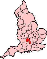
Oxfordshire is a ceremonial county in South East England. The county is bordered by Northamptonshire and Warwickshire to the north, Buckinghamshire to the east, Berkshire to the south, and Wiltshire and Gloucestershire to the west. The city of Oxford is the largest settlement and county town.
Witney is a market town on the River Windrush in West Oxfordshire in the county of Oxfordshire, England. It is 12 miles (19 km) west of Oxford.
Charlbury is a town and civil parish in the Evenlode valley, about 6 miles (10 km) north of Witney in the West Oxfordshire district of Oxfordshire, England. It is on the edge of Wychwood Forest and the Cotswolds. The 2011 Census recorded the parish's population as 2,830.
Woodstock is a market town and civil parish, 8 miles (13 km) north-west of Oxford in West Oxfordshire in the county of Oxfordshire, England. The 2021 census recorded a parish population of 3,521, up from the previous 3,100 in 2011.
Eynsham is a village and civil parish in the West Oxfordshire district, in Oxfordshire, England, about 5 miles (8 km) north-west of Oxford and east of Witney. The 2011 Census recorded a parish population of 4,648. It was estimated at 5,087 in 2020.
The county of Oxfordshire in England is broadly situated in the land between the River Thames to the south, the Cotswolds to the west, the Chilterns to the east and The Midlands to the north, with spurs running south to Henley-on-Thames and north to Banbury.
Long Hanborough is a village in Hanborough civil parish, about 4 miles (6.4 km) northeast of Witney in West Oxfordshire, England. The village is the major settlement in Hanborough parish. The 2011 Census recorded the parish's population as 2,630.
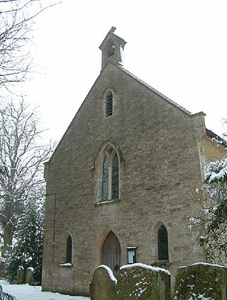
Milton-under-Wychwood is an English village and civil parish about 4 miles (6.4 km) north of Burford, Oxfordshire, just off the A361 road between Burford and Chipping Norton. The 2011 Census recorded the parish's population as 1,648.
Cogges is an area beside the River Windrush in Witney, in the West Oxfordshire district, in Oxfordshire, England, 0.5 miles (800 m) east of the town centre. It had been a separate village and until 1932 it was a separate civil parish.
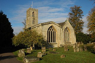
Leafield is a village and civil parish about 4 miles (6.4 km) northwest of Witney in West Oxfordshire, England. The parish includes the hamlet of Langley, 1 mile (1.6 km) west of Leafield village. The 2011 Census recorded the parish's population as 945. The village is 635 feet (194 m) above sea level in the Cotswold Hills. It was the highest point in Oxfordshire until the 1974 county boundary changes enlarged the county.
Yarnton is a village and civil parish in Oxfordshire about 1 mile (1.6 km) southwest of Kidlington and 4 miles (6 km) northwest of Oxford. The 2011 Census recorded the parish's population as 2,545.
Northmoor is a village and civil parish in West Oxfordshire, about 6 miles (10 km) west of Oxford and almost the same distance southeast of Witney. Northmoor is in the valley of the River Thames, which bounds the parish to the east and south, and is close to the River Windrush which forms part of the parish's western boundary. The 2011 Census recorded the parish's population as 377.
Stanton Harcourt is a village and civil parish in Oxfordshire about 4 miles (6.4 km) southeast of Witney and about 6 miles (10 km) west of Oxford. The parish includes the hamlet of Sutton, 1⁄2 mile (800 m) north of the village. The 2011 Census recorded the parish's population as 960.
Cassington is a village and civil parish in Oxfordshire about 5 miles (8 km) northwest of Oxford. The village lies on gravel strata about 1⁄2 mile (800 m) from the confluence of the River Evenlode with the River Thames. The parish includes the hamlet of Worton northeast of the village and the site of the former hamlet of Somerford to the south. Somerford seems to have been abandoned early in the 14th century. Cassington is formed of two parts, "upper" and "lower", each with its own village green. The 2011 Census recorded the parish's population as 750.
North Leigh is a village and civil parish about 3 miles (5 km) northeast of Witney in Oxfordshire. The parish includes the hamlet of East End and since 1932 has also included the hamlet of Wilcote. The 2011 Census recorded the parish's population as 1,929.
Brighthampton is a hamlet which is contiguous with the village of Standlake, about 4 miles (6.4 km) south of Witney, in West Oxfordshire, in the county of Oxfordshire, England.
Finstock is a village and civil parish about 2 miles (3 km) south of Charlbury in Oxfordshire, England. The parish is bounded to the northeast by the River Evenlode, to the southeast partly by the course of Akeman Street Roman road, and on other sides by field boundaries. The 2011 census recorded the parish's population as 797. For most of its history Finstock was a township of the ancient parish of Charlbury. Finstock became a separate civil parish in the late 19th century.
South Leigh is a village in the civil parish of South Leigh and High Cogges, in the West Oxfordshire district, in Oxfordshire, England, on Limb Brook, a small tributary of the River Thames, about 2+1⁄2 miles (4 km) east of Witney. The 2011 Census recorded the parish's population as 336. On 1 January 2024 the parish was renamed from "South Leigh" to "South Leigh and High Cogges".
Hailey is a village and civil parish about 2 miles (3 km) north of Witney, Oxfordshire. The village comprises three neighbourhoods: Middletown on the main road between Witney and Charlbury, Poffley End on the minor road to Ramsden and Delly End on Whiting's Lane. The parish extends from the River Windrush in the south, almost to the village of Ramsden and the hamlet of Wilcote in the north, and it includes the hamlet of New Yatt. The 2011 Census recorded the parish's population as 1,208.
Wilcote is a hamlet in the civil parish of North Leigh, in the West Oxfordshire district, in Oxfordshire, England, about 3+1⁄2 miles (5.6 km) north of Witney.