Coldharbour, Tower Hamlets

Last updated

Coldharbour
Coldharbour.jpg
Isle House at the northern end of Coldharbour
Location Tower Hamlets, London
Postal code E14
Coordinates 51°30′10″N0°00′27″W / 51.5028°N 0.0075°W / 51.5028; -0.0075 TQ383908

Coldharbour is a street and wider conservation area of the Blackwall area in Poplar, lying on the north bank of the River Thames, east of Canary Wharf. The area is said to be "[t]he sole remaining fragment of the old hamlet of Blackwall" and "one of the last examples of the narrow streets which once characterised the river's perimeter". [1]

Contents

History

Toponymy

The placename Coldharbour came in use from the early seventeenth century [2] and its origins have been debated since the 1850s. [3] Conflicting etymologies are given by authorities, with Ernest Weekley contending that "[t]his name is very frequently, and very unnecessarily, discussed. Its origin is quite well known, and it means what it appears to mean." [4]

Those accepting the plainest derivation [4] [5] argue that a cold harbour was a "shelter of bare walls... used by travellers who carried their own bedding and provisions", [5] often along a well-known route and similar to a modern bothy.

In alternative, a "coldharbour" could indicate ancient boundary marks in the form of artificial mounds of earth from Roman times, often filled with crockery or charcoal. The word could be derived either from the Latin collis arborum, meaning "hill with trees", or from the Anglo-Saxon col, meaning "coal" or "charcoal", har, "hoary" or "ancient", and bearth, a mound. [6] The link with Roman roads has been contested [7] on the basis that the proximity of Roman roads provides a statistically weak explanation and the fact that the name is not recorded before 1590.

It has also been suggested that most Coldharbour sites could have been named in a mocking manner after a dilapidated London aristocratic house. [7] Other interpretations include "a place where goods were once... assembled for inland water transport or for portage." [8]

Development

North Wharf, Coldharbour North Wharf, London.jpg
North Wharf, Coldharbour

Coldharbour was originally a path on the top of the late Mediaeval embankment of the Thames [9] connecting Blackwall Stairs to "somewhere near the present entrance to the south dock of the West India Docks". [10]

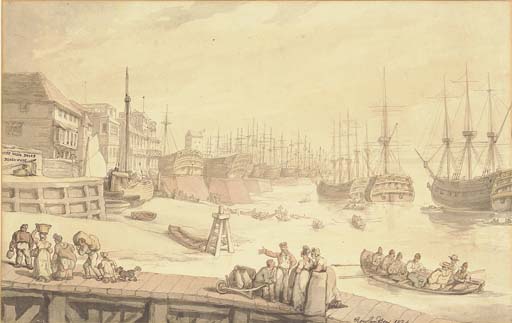
The first buildings on Coldharbour appeared by the second decade of the seventeenth century, probably as part of the activities spreading on the Thames riverfront after the opening of the East India Company's shipbuilding yard at Blackwall in 1614. [10] A "ribbon of development" alongside the river at Coldharbour is marked on Joel Gascoyne's map of the Parish of St Dunstan's of 1703, comprising "dwelling houses, public houses, storehouses and warehouses ... interspersed with wharves, yards and even gardens." [10]

John Betjeman describing Coldharbour as a place "where some fine Georgian merchants' houses have the water washing up to their walls". [11] Although the oldest surviving buildings date back to the early nineteenth century, "many of the riverside sites retain an integrity which can be traced back to the seventeenth and eighteenth centuries." [10]

The opening of the West India Docks (in 1802) and the City Canal (in 1805) cut off Coldharbour from the rest of the riverside road, with traffic being diverted to a newly built Bridge Road (later New Road, now Preston's Road) in 1817. [10] Evidence of land reclamation, probably related to the digging of the docks and canals in the early nineteenth century, was identified by an archaeological survey. [12] These changes gave Coldharbour its present layout as "a tiny loop road off Preston's Road," [13] upon which architectural critic Ian Nairn remarked: "You will know a bit about East End topography by the time you find this one." [13]

The area between Coldharbour and Preston's Road was progressively developed from the eighteenth century with dwellings around the northern end and mixed industrial premises, including shipwrights, joiners, mast- and blockmakers, ship's smiths, a rigging house, a cooperage, a boot-building yard, coppersmiths, wholesale ships' ironmongers and oil merchants. [10]

Character of the area

An investigator compiling Booth's poverty maps noted the following about the Isle of Dogs and Coldharbour: "A great many more people work there than live there, though many of those who live there would like to work there. Those who live there seldom leave. From week to week and year to year the men who are islanders remain there." [14]

Cold Harbour Infectious Diseases Receiving Station

In 1882 the Metropolitan Asylums Board (MAB) moved its smallpox hospital ships – the Atlas , the Endymion and the Castalia – to new moorings at Long Reach, an isolated stretch of the River Thames near Dartford, about 17 miles (27 km) from London Bridge. The removal of the ships to their new location required the provision of a River Ambulance Service to ferry patients from central London. The following year a pier was constructed at Long Reach for the reception of smallpox cases from wharves to be built at Rotherhithe, Poplar and Fulham.

This 1870s a Cattle Wharf was acquired by the MAB, just north of the Gun public house in Cold Harbour (until the MAB took it over in 1884 it was used by the General Steam Navigation Company for keeping imported cattle in quarantine), with the aim to build the new "North Wharf Receiving Station" for infectious diseases.

The East and West India Dock Company was dismayed at the prospect of highly contagious patients being brought to North Wharf along the narrow confines of Coldharbour, where several of the company’s dockmasters lived. This potential source of conflict was averted when the MAB decided to make a new road between Coldharbour and New (now Preston’s) Road over their land on the west side of the street, and the dock company readily consented to give up the small strip required to make the opening into New Road. Laid out in 1884–5, the new road was called Managers Street, after the managers of the Metropolitan Asylums Board. At the wharf itself the MAB’s main requirement was a floating pier or pontoon, so that the transfer of patients could take place at all states of the tide. It was connected to the wharf by a gangway. Both these features were designed by the MAB’s own engineer, Adam Miller (also described as a naval architect), who had devised the ventilation system for the hospital ship Castalia. A galvanised-iron canopy was built in 1887 to protect patients, who were getting soaked through waiting for ambulances in the rain.

The Receiving Station had an examination room and an isolation ward for patients too sick to be transferred by river ambulance to Long Reach.  Other land works were postponed while priority was given to building of the pier, which opened in 1885, just as the epidemic subsided. As the number of smallpox cases declined, the service was reorganised in 1913.  The North Wharf was used only for smallpox patients, while the South Wharf at Rotherhithe dealt with general fever cases. By 1921 the North Wharf had 9 beds.

In 1930 the LCC took over administrative control from MAB.  By this time the river service was rarely used, most patients being transferred by road.  The service closed in May 1930 and, by 1933, the steamers had been sold. By the 1980s, the pier and pontoon had been removed and the wharf was being used for storing wood.

The buildings were demolished in 1992 and as part of the revival of the Docklands, in 1997 the land of 17 Coldharbour was redeveloped by the Bethnal Green and Victoria Park Housing Association with a £370,000 grant [15] from the London Docklands Development Corporation's housing programme. [16]

Famous local individuals

Raleigh's house at Blackwall, London, 1873. Sir Walter Raleigh's House at Blackwall.jpg
Raleigh's house at Blackwall, London, 1873.

Heritage

The industrial and maritime activities of Coldharbour's past are no more and today the area is largely residential. The Coldharbour conservation area, designated in 1975 and expanded in 2008, [1] comprehends several historic buildings as well as engineering structures pertaining to the former docks.

Listed buildings

Coldharbour, looking north. The column of glazed bricks on the right marks the site of the Fishing Smack pub, linked to Charles Dickens. Coldharbour, London.jpg
Coldharbour, looking north. The column of glazed bricks on the right marks the site of the Fishing Smack pub, linked to Charles Dickens.

The area is said to be "[t]he sole remaining fragment of the old hamlet of Blackwall" and "one of the last examples of the narrow streets which once characterised the river's perimeter". [26] The modern surroundings, which include Canary Wharf and The O2 Arena, contribute to "making this surviving pocket all the more valuable and remarkable." [1]

Several buildings in the conservation area, dating mostly to the late 18th and early 19th century, have listed status: [1]

Isle House, at no. 1, was built in 1825–1826 by the West India Dock Company and used as a dock master's residence until the 1880s. Reputed to be "the finest house in Coldharbour," it was built with two storeys raised above a tall basement and full-height bow windows on the east and north fronts to give the occupants clear views of the Thames and the Blackwall entrance to the Docks. [10]

Notable engineering structures include the northern entrance to the West India Basin and the entrance to the former City Canal, which cut across the peninsula and gave the "Isle" of Dogs its insular title. Public access to the street, entrance locks and to the perimeter of the Blackwall Basin and Graving Dock is maintained. [1]

The riverside

An extension of the Thames Path runs along Coldharbour, [27] where the river view is obstructed by a series of buildings. Public access to the riverside is possible at the former entrance to Blackwall Basin, now sealed, and by Lockeryard Pier, where the path rejoins the Thames waterfront at the height of Stewart St. [27]

The architectural critic Ian Nairn noted that this "particular bit of the riverside is the sharpest part of the curve around Blackwall Point. Nowhere is the muddy horizontal excitement of the Thames more urgent than here, [...] the curvature making sure that the maximum amount of swift-running water stays in view." [13]

Geography

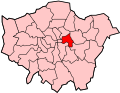
Coldharbour is situated in the London Borough of Tower Hamlets and is bounded by Landons Close to the north, by Marsh Wall to the south, by Preston Road and Wood Wharf to the west and by the river Thames to the east.

BBC World Service editor Andrew Whitehead described it as a "little enclave of riverine London ... spitting distance from Canary Wharf but sealed off from it by dock basins, new developments, and sturdy boundary walls." [28]

Transport

Docklands Light Railway

While there are no stations in Coldharbour, the nearest station is Blackwall DLR station in neighbouring Blackwall on the Docklands Light Railway in Travelcard Zone 2 that opened on 28 March 1994.

London Buses

Current routes
RouteStartEndServed area sinceNotes
D6 Crossharbour ASDA Ash Grove 24.05.08 [29]
D7 Mile End Underground no-text.svg All Saints 18.09.1999 [30]
N550 Canning Town Underground no-text.svg DLR no-text roundel.svg London Buses square.svg Trafalgar Square 29.08.08 [31]
Previous

Roads

Coldharbour is connected to the National Road Network by the north-south Prestons Road A1206.

Education

Nearest places

Notes

  1. 1 2 3 4 5 London Borough of Tower Hamlets. 2009. Coldharbour Conservation Area. Archived 1 September 2012 at the Wayback Machine
  2. Gover, John Eric Bruce; Mawer, Allen; Stenton, Frank Merry. 1942. The Place-Names of Middlesex apart from the City of London. Cambridge: Cambridge University Press. P. 136.
  3. C. M. J. 1850. Cold Harbour. Archived 25 April 2012 at the Wayback Machine Notes and Queries s1-II 51.
  4. 1 2 Weekley, Ernest. 1927. More Words Ancient and Modern. London: John Murrey. P. 162n.
  5. 1 2 Taylor, Isaac. 1865. Words and places; or, Etymological illustrations of history, ethnology, and geography. London and Cambridge: Macmillan and Co. Pp. 255–256.
  6. Sharpe, Montagu. 1922. Coldharbour (Letters to the Editor). The Times, 23 May.
  7. 1 2 Coates, Richard. 1984. Coldharbour – for the Last Time? Nomina 8: 73–78.
  8. Rendel, Vincent. 1967. The meaning of "Coldharbour". Kent Archeological Review 7
  9. Ford, Steve. 1995. North Wharf, Coldharbour, Blackwall, Tower Hamlets: Archeological Evaluation, Thames Valley Archeological Services Report95/42. P. 1. Accessed: 22 October 2011
  10. 1 2 3 4 5 6 7 8 9 Porter, Stephen. 1994. Southern Blackwall: Coldharbour. Survey of London: Volumes 43 and 44: Poplar, Blackwall and Isle of Dogs. London: The Athlone Press for the Royal Commission on the Historical Monuments of England. Pp. 607–624. Accessed: 23 October 2011.
  11. Betjeman, John. 1956. City and Suburban. The Spectator, 31 May. P. 13.
  12. No author. 1995. Fieldwork Round-Up, London Archeologist 08, Supplement 1, p. 23. Accessed: 22 October 2011
  13. 1 2 3 Nairm, Ian. 1966. The Gun, Coldharbour. In Nairn's London. Harmondsworth: Penguin Books. Pp. 163–164.
  14. Booth, Charles. 1897. Walk with Mr Carter, District Inspector of Police, District 11 (Poplar and Limehouse), 28 May 1897. Archived 15 April 2012 at the Wayback Machine LSE Archives, Booth B346. Pp. 18–19.
  15. 1999. Housing: Appendix – Tables: TABLE 3 LDDC New Build Social Housing Programme. LDDC History Pages. Accessed: 25 October 2011.
  16. LDDC. 1996. Housing in London Docklands. London: London Docklands Development Corporation. P. 4. Accessed: 25 October 2011.
  17. Haw, George. 1909. From Workhouse to Westminster: The Life Story of Will Crooks, M.P. Cassell and Co.: London, New York, Toronto and Melbourne. P. 32. Accessed: 17 February 2013.
  18. Dickens, Charles. 1853. Exploring Expedition to the Isle of Dogs. In "Household Words. A Weekly Journal," 21 May. Pp. 273–277.
  19. St George, Genevieve. 2009. Trafalgar Day Walk in London October 21st 2009. Nelson Society, 4 Sep.
  20. 2011. History. The Gun Pub.
  21. The Gun: Good Lunch, Not Such a Good Walk. Archived 19 August 2014 at the Wayback Machine Thames Facing East, 19 March 2013. Accessed: 27 March 2013.
  22. Porter, Stephen. 1994. Old Blackwall. Survey of London: Volumes 43 and 44: Poplar, Blackwall and Isle of Dogs. London: The Athlone Press for the Royal Commission on the Historical Monuments of England. Pp. 548–552. Accessed: 17 February 2013.
  23. Thorne, Wm. B. 1935. Artichoke Tavern, Blackwall Notes and Queries 168, p. 196. Accessed: 17 February 2013.
  24. Royall, Arthur. 1999. The Streets of Poplar. Prebendary Arthur Royall's Articles. Accessed: 25 October 2011.
  25. Sir Thomas Spert (died 1541). PortCities London. Accessed: 25 October 2011.
  26. LBTH. 2007. Coldharbour Conservation Area. Archived 19 August 2014 at the Wayback Machine London Borough of Tower Hamlets.
  27. 1 2 WalkLondon. 2011. Thames Path Walk: Section 4 north bank (Island Gardens to East India). Archived 29 November 2011 at the Wayback Machine
  28. Andrew Whitehead. 2013. Out Beyond Limehouse – An End of Year Ramble. AndrewWhitehead.net, 29 Dec Accessed: 30 December 2013
  29. "London Buses Route D6".
  30. "London Bus Route D7".
  31. "London Night Bus Route N550".
  32. "London Bus Route 56". Archived from the original on 17 May 2016. Retrieved 4 May 2016.
  33. "London Bus Route 106".
  34. "London Bus Route 277".
  35. "London Buses Route N50".
Coldharbour in paintings
Historical maps of Coldharbour

Related Research Articles

<span class="mw-page-title-main">London Docklands</span> Area by the Thames in London, England

London Docklands is the riverfront and former docks in London. It is located in inner east and southeast London, in the boroughs of Southwark, Tower Hamlets, Lewisham, Newham, and Greenwich. The docks were formerly part of the Port of London, at one time the world's largest port. After the docks closed, the area had become derelict and poverty-ridden by the 1980s. The Docklands' regeneration began later that decade; it has been redeveloped principally for commercial and residential use. The name "London Docklands" was used for the first time in a government report on redevelopment plans in 1971 and has since been almost universally adopted. The redevelopment created wealth, but also led to some conflict between the new and old communities in the area.

<span class="mw-page-title-main">Isle of Dogs</span> Area in the East End of London, England

The Isle of Dogs is a large peninsula bounded on three sides by a large meander in the River Thames in East London, England, which includes the Cubitt Town, Millwall and Canary Wharf districts. The area was historically part of the Manor, Hamlet, Parish and, for a time, the wider borough of Poplar. The name had no official status until the 1987 creation of the Isle of Dogs Neighbourhood by Tower Hamlets London Borough Council. It has been known locally as simply "the Island" since the 19th century.

<span class="mw-page-title-main">Limehouse</span> District in Tower Hamlets, London

Limehouse is a district in the London Borough of Tower Hamlets in East London. It is 3.9 miles (6.3 km) east of Charing Cross, on the northern bank of the River Thames. Its proximity to the river has given it a strong maritime character, which it retains through its riverside public houses and steps, such as The Grapes and Limehouse Stairs. It is part of the traditional county of Middlesex. It became part of the ceremonial County of London following the passing of the Local Government Act 1888, and then part of Greater London in 1965.

<span class="mw-page-title-main">Poplar, London</span> Area of East London, England

Poplar is a district in East London, England, now part of the London Borough of Tower Hamlets. Five miles (8 km) east of Charing Cross, it is part of the East End.

<span class="mw-page-title-main">Canary Wharf</span> Major business and financial district in London, England

Canary Wharf is an area of East London, England, located near the Isle of Dogs in the London Borough of Tower Hamlets. Canary Wharf is defined by the Greater London Authority as being part of London's central business district, alongside Central London. Alongside the City of London, it constitutes one of the main financial centres in the United Kingdom and the world, containing many high-rise buildings including the third-tallest in the UK, One Canada Square, which opened on 26 August 1991.

<span class="mw-page-title-main">West India Docks</span> Historic dock site, now part of Canary Wharf area.

The West India Docks are a series of three docks, quaysides and warehouses built to import goods from and export goods and occasionally passengers to the British West Indies on the Isle of Dogs in London the first of which opened in 1802. Following their commercial closure in 1980, the Canary Wharf development was built around the wet docks by narrowing some of their broadest tracts.

<span class="mw-page-title-main">Blackwall, London</span> Area of the East End of London, England

Blackwall is an area of Poplar, in the London Borough of Tower Hamlets, East London. The neighbourhood includes Leamouth and the Coldharbour conservation area.

<span class="mw-page-title-main">Millwall</span> Area of the Isle of Dogs in London, England

Millwall is a district on the western and southern side of the Isle of Dogs, in east London, England, in the London Borough of Tower Hamlets. It lies to the immediate south of Canary Wharf and Limehouse, north of Greenwich and Deptford, east of Rotherhithe, west of Cubitt Town, and has a long shoreline along London's Tideway, part of the River Thames. It was part of the County of Middlesex and from 1889 the County of London following the passing of the Local Government Act 1888, it later became part of Greater London in 1965.

<span class="mw-page-title-main">Pool of London</span> Area of the Thames

The Pool of London is a stretch of the River Thames from London Bridge to below Limehouse.

<span class="mw-page-title-main">London Docklands Development Corporation</span> English regeneration agency (1981–1998)

The London Docklands Development Corporation (LDDC) was a quango agency set up by the UK Government in 1981 to regenerate the depressed Docklands area of east London. During its seventeen-year existence it was responsible for regenerating an area of 8.5 square miles (22 km2) in the London Boroughs of Newham, Tower Hamlets and Southwark. LDDC helped to create Canary Wharf, Surrey Quays shopping centre, London City Airport, ExCeL Exhibition Centre, London Arena and the Docklands Light Railway, bringing more than 120,000 new jobs to the Docklands and making the area highly sought after for housing. Although initially fiercely resisted by local councils and residents, today it is generally regarded as having been a success and is now used as an exemplar of large-scale regeneration, although tensions between older and more recent residents remain.

<span class="mw-page-title-main">Limehouse Link tunnel</span> Road tunnel under Limehouse in East London

The Limehouse Link tunnel is a 1.1-mile (1.8 km) long tunnel under Limehouse in East London on the A1203 road. The tunnel links the eastern end of The Highway to Canary Wharf in London Docklands. Built between 1989 and 1993 at a cost of £293,000,000 it has been calculated as the most expensive road scheme in Britain per mile, working out at £50,500 per foot at 2011 prices. It is the second largest non-estuarial road tunnel in the UK, after the Hindhead Tunnel in Surrey.

<span class="mw-page-title-main">North Greenwich, Isle of Dogs</span> Human settlement in England

North Greenwich is a formal 19th century name for an area now in Millwall situated at the very southern tip of the Isle of Dogs, in the London Borough of Tower Hamlets. It lies to the south of the commercial estates of West India Docks including Canary Wharf and has a short shoreline along London's Tideway part of the River Thames.

<span class="mw-page-title-main">Cubitt Town</span> Area on the Isle of Dogs in London, England

Cubitt Town is a district on the eastern side of the Isle of Dogs in London, England. This part of the former Metropolitan Borough of Poplar was redeveloped as part of the Port of London in the 1840s and 1850s by William Cubitt, Lord Mayor of London (1860–1862), after whom it is named. It is on the east of the Isle, facing the Royal Borough of Greenwich across the River Thames. To the west is Millwall, to the east and south is Greenwich, to the northwest Canary Wharf, and to the north — across the Blue Bridge — is Blackwall. The district is situated within the Blackwall & Cubitt Town Ward of Tower Hamlets London Borough Council.

<span class="mw-page-title-main">Leamouth</span> Human settlement in England

Leamouth is a locality in the Blackwall area of Poplar of the London Borough of Tower Hamlets. The area takes its name from the former Leamouth Wharf and lies on the west side of the confluence of the Bow Creek stretch of the Lea, at its confluence with the River Thames.

Poplar (East India Road) was a railway station located on the East India Dock Road in Poplar, London. It was opened in 1866 by the North London Railway. It was the southern passenger terminus of the NLR, although goods trains ran on to connect to the London and Blackwall Railway (LBR) for the East India Docks or to the LBR's Millwall Extension Railway for the West India Docks.

<span class="mw-page-title-main">London Buses route 277</span> London bus route

London Buses route 277 is a Transport for London contracted bus route in London, England. Running between Cubitt Town and Dalston Junction station, it is operated by Stagecoach London.

<span class="mw-page-title-main">A1206 road (Great Britain)</span> Road around the Isle of Dogs, in the east of London, England

The A1206, also known as the Isle of Dogs Distributor Road, is a crescent-shaped ring road around the Isle of Dogs, in the East End of London. It is made up of Westferry Road, Manchester Road and Prestons Road and is the main road through the area, connecting parts of the London Docklands.

<span class="mw-page-title-main">The Gun, Coldharbour</span> Pub in Coldharbour, London

The Gun is a Grade II listed public house at 27 Coldharbour, Coldharbour, London. It takes its name from the cannon which was fired when the West India Docks first opened in 1802.

<span class="mw-page-title-main">Cascades, Isle of Dogs</span> Residential building in London

Cascades Tower is a 20-storey residential building and a distinctive local landmark on the Isle of Dogs in East London. It was designed by Rex Wilkinson, a partner in the celebrated architectural firm CZWG, and built in 1987–88.

<span class="mw-page-title-main">West India Pier</span> Disused pier on the River Thames

West India Pier is a pier on the River Thames in the Isle of Dogs area of London. It can be found beside the Anchorage Point and Millennium Harbour housing developments at the end of Cuba Street.