Interstate 27 (I-27) is an Interstate Highway, entirely in the US state of Texas, running north from Lubbock to I-40 in Amarillo. These two cities are the only control cities on I-27; other cities and towns served by I-27 include New Deal, Abernathy, Hale Center, Plainview, Kress, Tulia, Happy, and Canyon. In Amarillo, I-27 is commonly known as the Canyon Expressway, although it is also called Canyon Drive on its access roads. I-27 was officially designated the Marshall Formby Memorial Highway after former attorney and Texas State Senator Marshall Formby in 2005. The entire length of I-27 replaced U.S. Route 87 (US 87) for through traffic.
Interstate 30 (I-30) is a 366.76-mile-long (590.24 km) Interstate Highway in the southern states of Texas and Arkansas in the United States. I-30 travels from I-20 west of Fort Worth, Texas, northeast via Dallas, and Texarkana, Texas, to I-40 in North Little Rock, Arkansas. The highway parallels U.S. Highway 67 (US 67) except for the portion west of downtown Dallas. Between the termini, I-30 has interchanges with I-35W, I-35E, and I-45. I-30 is known as the Tom Landry Freeway between I-35W and I-35E, within the core of the Dallas–Fort Worth metroplex.
Interstate 45 (I-45) is a major Interstate Highway located entirely within the US state of Texas. While most Interstate routes which have numbers ending in "5" are crosscountry north–south routes, I-45 is comparatively short, with the entire route located in Texas. It connects the cities of Dallas and Houston, continuing southeast from Houston to Galveston over the Galveston Causeway to the Gulf of Mexico.

Royse City is a city in Rockwall County in the U.S. state of Texas. It also extends into Collin and Hunt Counties. The population was 2,957 at the 2000 census, rising to 9,349 in 2010. The estimated population in 2018 was 12,998.
State Highway 121 is a state highway angling from southwest to northeast through north central Texas. It runs from downtown Fort Worth, Texas at the junction of Interstate 35W to Bonham, Texas, just north of a junction with U.S. Highway 82.

State Highway 360 is a 28-mile (45 km) north–south state highway in the Dallas–Fort Worth metroplex in the U.S. state of Texas. It runs north from an at-grade intersection with US 287 in Mansfield, near the Ellis-Johnson county line to a partial interchange with SH 121 in Grapevine, near Dallas/Fort Worth International Airport. The highway serves as a local north–south route running through the center of the metroplex, linking together the southern and northern suburbs to the core. Between US 287 and Camp Wisdom Road/Sublett Road, SH 360 follows a pair of frontage roads along a four-lane tollway known as the 360 Tollway, a tollway operated by the NTTA. Between Camp Wisdom Road/Sublett Road and SH 121, SH 360 follows a toll-free freeway maintained by TxDOT.
Interstate 610 (I-610) is a freeway that forms a 38-mile-long (61 km) loop around the inner city sector of the city of Houston, Texas. I-610, colloquially known as The Loop, Loop 610, The Inner Loop, or just 610, traditionally marks the border between the inner city of Houston and its surrounding areas. It is the innermost of the three Houston beltways, the other two being Beltway 8 and State Highway 99, of which various segments are under construction or planning. In Houston, the area inside the 610 Loop is the urban core. Jeff Balke of the Houston Press wrote that the freeway "is as much a social and philosophical divide as a physical one".
Texas Highway 99, also known as the Grand Parkway Toll Road, is a ring road in Texas, United States, that opened its first section on August 31, 1994. When TX 99 Grand Parkway Toll is complete, it will be the longest beltway in the United States of America, the seventh longest ring road on Earth, and the third (outer) loop within Houston–The Woodlands–Sugar Land metro area, with I-610 (Texas) I-610 being the first (inner) loop, and Beltway 8 being the second (middle) loop. The proposed 170-mile (270 km) loop has been divided into 11 separate segments for construction and funding purposes. In May 2019, the Texas Department of Transportation gave the Grand Parkway Toll Road a secondary, yet honorable designation as the Mayor Bob Lanier Memorial Parkway. Bob Lanier, who served as the mayor of Houston from 1992 to 1998, had spearheaded the creation of the Grand Parkway.

Beltway 8 (BW8), the Sam Houston Parkway, along with the Sam Houston Tollway, is an 88-mile (142 km) beltway around the city of Houston, Texas, United States, lying entirely within Harris County.
The President George Bush Turnpike (PGBT) is a 52-mile (84 km) toll road running through the northern, northeastern and western suburbs, forming a partial loop around Dallas, Texas, United States. It is named for the late George H. W. Bush, the 41st president of the United States. At its west end near Belt Line Road in Irving, State Highway 161 continues southwest to Interstate 20 (I-20) in Grand Prairie. The discontinuous free frontage roads along the turnpike from I-35E in Carrollton east to its end at I-30 in Garland are assigned the State Highway 190 designation. SH 190 signage appears only along the Rowlett, Garland, Richardson, Plano, and Carrollton sections of the frontage road with the undersign "frontage road only". At intersections with city streets, only the Bush Turnpike signs are displayed, not the SH 190 signage. Prior to the construction of the main lanes as a tollway, SH 190 was used as the name of the planned main lanes too. Similarly, the part west of I-35E was planned as part of SH 161. Bush Turnpike is signed as a north–south road from I-20 to I-35E, an east–west road from I-35E to the Merritt Main Lane Gantry and as a north–south road from the Merritt Main Lane Gantry to I-30, as Bush Turnpike makes a nearly 90-degree curve in both places.

Loop 12 is a state highway that runs mostly within the city limits of Dallas, Texas. The western segment of the loop is named after General Walton Walker, who served and died in South Korea. During the 1950s and 1960s, Loop 12 was the outer beltway in the Dallas area, having since been supplanted by Interstate 635, which is itself being supplanted by the President George Bush Turnpike. Loop 12 is, however, the only state highway in Dallas that forms a complete loop.

State Highway 289, known for most of its length as Preston Road, is a north–south Texas state highway. It begins at the intersection of Preston Road and Loop 12/Northwest Highway in Dallas. The Preston Road designation comes from the fact that the highway generally follows the course of an older road known as the Preston Trail, which ran to the town of Preston [Bend]. Preston is now submerged by Lake Texoma. The road is known as Preston all the way north through the remainder of the Dallas-Fort Worth Metroplex to a junction with State Highway 56 west of Sherman, near the Oklahoma border. Preston Road passes through many of the fast-growing northern Dallas suburbs, including Frisco and Plano, as well as Prosper and Celina, with many new housing developments being built along Preston.

The Dallas North Tollway is a 30.2-mile (49 km) controlled-access toll road operated by the North Texas Tollway Authority (NTTA), which runs from Interstate 35E near downtown Dallas, Texas (USA), to U.S. Highway 380, in Frisco, Texas.
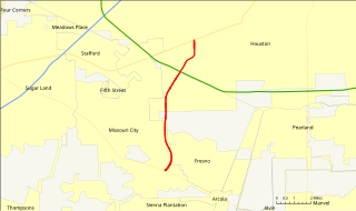
The Fort Bend Parkway Toll Road is the Fort Bend County (i.e.,southern) portion of a continuous toll road connecting Sienna Plantation in eastern Fort Bend County to US 90A in southwestern Harris County. It is administered by the Fort Bend County Toll Road Authority (FBCTRA). The Harris County Toll Road Authority (HCTRA) administers the Harris County segment of the road — from just south of Beltway 8 at the county line to US 90A — and uses its purple pentagonal shield labeled as Fort Bend Toll Road. It is proposed to reach a northern terminus at the southwestern corner of Interstate 610 in the future, and SH 99 at its southern terminus.

U.S. Highway 90 Alternate is an alternate route to U.S. Highway 90 in the U.S. state of Texas, running from west of Seguin east via Seguin, Gonzales, Hallettsville, Eagle Lake, Rosenberg and Sugar Land to northeastern Houston. South of Downtown Houston, US 90 Alternate is built to freeway and near-freeway standards along a section of South Main Street.
Loop 49 is a currently 32-mile (51 km) circular tollway that, along with I-20, will encircle the city of Tyler and serve other various communities in Northeast Texas upon its completion. Routing of the loop north of I-20 bypasses Lindale to the west and passes by the west and south sides of Tyler south of I-20. The highway interconnects suburban areas and areas of potential development around Tyler with I-20 and provides local areas easier access to the Dallas–Fort Worth metroplex.
Loop 289 is a multi-lane beltway servicing Lubbock as a freeway. The highway serves as the southern end for Interstate 27 on the south side of the city. The highway passes about a mile south of Lubbock Preston Smith International Airport on the north side near the intersection with I-27.
Northwest Highway is a major highway/road in the Dallas-Fort Worth Metroplex area of Texas. The highway was originally built as the route of State Highway 114 into Dallas. The road has been the site of major development for almost half a decade, especially in Dallas. The route is known as other names at various points. This includes Northwest Parkway and Northwest Drive in Mesquite.
Farm to Market Road 548 is a Farm to Market Road located in the eastern portion of the Dallas-Fort Worth metroplex.
