
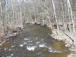
Shickshinny Creek is a tributary of the Susquehanna River in the Wyoming Valley in Luzerne County, Pennsylvania, in the United States. It is approximately 10.1 miles (16.3 km) long and flows through Ross Township, Union Township, and Shickshinny. Its watershed has an area of 35.0 square miles (91 km2) and its tributaries include Culver Creek, Reyburn Creek, and Little Shickshinny Creek. The creek is designated as a Coldwater Fishery and a Migratory Fishery. A sawmill and a gristmill were built on the creek in 1802 and 1804, respectively. Several bridges have also been constructed over it. The creek was historically polluted by culm near its mouth, but agriculture was the main industry in the watershed in the early 1900s. It was historically used as a water supply.
Little Wapwallopen Creek is a tributary of the Susquehanna River in Luzerne County, Pennsylvania, in the United States. It is approximately 17 miles (27 km) long and flows through Rice Township, Dorrance Township, Conyngham Township, and Hollenback Township. The watershed of the creek has an area of 39.5 square miles (102 km2). The creek is designated as a Coldwater Fishery and a Migratory Fishery and is not considered to be impaired. It has two named tributaries: Pond Creek and Nuangola Outlet. Wild trout naturally reproduce in the creek.

Crooked Creek is a tributary of Kitchen Creek in Luzerne County, Pennsylvania, in the United States. It is approximately 1.8 miles (2.9 km) long and flows through Fairmount Township. The watershed of the creek has an area of 1.20 square miles (3.1 km2) and there is one named tributary. The creek is considered to be Class A Wild Trout Waters and a portion of it flows through Ricketts Glen State Park. Wisconsinan Till, Wisconsinan Outwash, and alluvium can be found in its vicinity.
Wasp Branch is a tributary of Pine Creek in Luzerne County, Pennsylvania, in the United States. It is approximately 1.7 miles (2.7 km) long and flows through Fairmount Township. The watershed of the stream has an area of 0.90 square miles (2.3 km2). The stream is considered to be Class A Wild Trout Waters, a Coldwater Fishery, and a Migratory Fishery. Glacial till and bedrock consisting of stone and shale can be found in the stream's vicinity.

Balliet Run is a tributary of Big Wapwallopen Creek in Luzerne County, Pennsylvania, in the United States. It is approximately 7.3 miles (11.7 km) long and flows through Dorrance Township, Hollenback Township, and Butler Township. The watershed of the stream has an area of 7.23 square miles (18.7 km2). The stream itself is fairly small and has two unnamed tributaries. It is considered to be Class A Wild Trout Waters and is inhabited by brook trout and brown trout. Wisconsinan Till, fill, and bedrock consisting of sandstone, conglomerate, and shale occur in the vicinity of the stream.

Bow Creek is a tributary of Big Wapwallopen Creek in Luzerne County, Pennsylvania, in the United States. It is approximately 4.5 miles (7.2 km) long and flows through Fairview Township and Wright Township. The watershed of the creek has an area of 4.69 square miles (12.1 km2). The creek has no named tributaries, but several unnamed ones, such as Bow Creek Tributary A. Bow Creek has been historically nearly devoid of life, but is now considered to be Class A Wild Trout Waters. There is a bridge carrying Pennsylvania Route 309 across the creek. Wisconsinan Till, alluvium, and bedrock consisting of sandstone, shale, conglomerate, and coal occur in the watershed. Several volatile organic compounds have been detected in small amounts in surface water in the watershed. The creek occasionally floods, but such flooding typically causes little damage.
Fades Creek is a tributary of Pikes Creek in Luzerne County, Pennsylvania, in the United States. It is approximately 3.2 miles (5.1 km) long and flows through Lake Township. The watershed of the creek has an area of 2.07 square miles (5.4 km2). It has one unnamed tributary and is designated as a High-Quality Coldwater Fishery and Class A Wild Trout Waters for part of its length. The creek is crossed by a pipeline and a bridge carrying Pennsylvania Route 118. Wisconsinan Ice-Intact Stratified Drift, alluvium, Wisconsinan Till, Wisconsinan Bouldery Till, and bedrock consisting of sandstone and shale all occur in the surficial geology in the creek's vicinity.
Little Nescopeck Creek is a tributary of Nescopeck Creek in Luzerne County, Pennsylvania, in the United States. It is approximately 8.2 miles (13.2 km) long and flows through Bear Creek Township, Fairview Township, and Dennsion Township. The watershed of the creek has an area of 10.7 square miles (28 km2). The creek has one named tributary, which is known as Conety Run. Little Nescopeck Creek is designated as a Coldwater Fishery and Class A Wild Trout Waters. It is one of the main sources of flooding in Dennison Township. The surficial geology in the vicinity of the creek mainly features alluvium, Wisconsinan Till, Wisconsinan Ice-Contact Stratified Drift, bedrock, and fill. Little Nescopeck Creek shares its name with another river in southern Luzerne county.
Rattlesnake Creek is a tributary of Spring Brook in Lackawanna County, Pennsylvania, in the United States. It is approximately 5.0 miles (8.0 km) long and flows through Spring Brook Township. The watershed of the creek has an area of 9.18 square miles (23.8 km2). The creek has one named tributary, which is known as Six Springs Creek. Rattlesnake Creek is inhabited by wild trout and part of it is considered to be Class A Wild Trout Waters. A dammed lake known as Maple Lake is located near its headwaters. The surficial geology in the area mainly consists of Wisconsinan Till and bedrock, with some alluvium, Wisconsinan Ice-Contact Stratified Drift, wetlands, and peat bogs.
Panther Creek is a tributary of Spring Brook in Lackawanna County, Pennsylvania, in the United States. It is approximately 2.7 miles (4.3 km) long and flows through Thornhurst Township, Clifton Township, and Spring Brook Township. The watershed of the creek has an area of 7.18 square miles (18.6 km2). It has one named tributary, which is known as Painter Creek. Panther Creek is considered to be Class A Wild Trout Waters. The surficial geology in its vicinity consists of alluvium, alluvial terrace, Wisconsinan Till, and bedrock.
Kellum Creek is a tributary of Roaring Brook in Lackawanna County, Pennsylvania, in the United States. It is approximately 2.9 miles (4.7 km) long and flows through Madison Township. The watershed of the creek has an area of 2.56 square miles (6.6 km2). The creek is considered to be Class A Wild Trout Waters. A planned trail is in its vicinity. The surficial geology in the area consists of alluvium, bedrock, peat bogs, wetlands, Boulder Colluvium, and Wisconsinan Till.

Roaring Run is a tributary of Bowman Creek in Wyoming County, Pennsylvania, in the United States. It is approximately 4.9 miles (7.9 km) long and flows through Forkston Township, Noxen Township, and Monroe Township. It has two named tributaries: Newton Run and South Branch Roaring Run. The watershed of Roaring Run has an area of 11.4 square miles (30 km2). It is designated as a High-Quality Coldwater Fishery and a Migratory Fishery and the stream is Class A Wild Trout Waters. The surficial geology in its vicinity consists of alluvium, alluvial terrace, alluvial fan, bedrock, Wisconsinan Till, and Wisconsinan Ice-Contact Stratified Drift. A bridge carrying Pennsylvania Route 29 crosses the stream.
South Branch Roaring Run is a tributary of Roaring Run in Wyoming County, Pennsylvania, in the United States. It is approximately 2.0 miles (3.2 km) long and flows through Noxen Township and Forkston Township. The watershed of the stream has an area of 3.31 square miles (8.6 km2). The surficial geology in its vicinity consists of bedrock, Wisconsinan Till, Wisconsinan Bouldery Till, Wisconsinan Ice-Contact Stratified Drift, and alluvium. South Branch Roaring Run is classified as Class A Wild Trout Waters.

Hettesheimer Run is a tributary of Bowman Creek in Wyoming County, Pennsylvania, in the United States. It is approximately 1.6 miles (2.6 km) long and flows through Noxen Township. The watershed of the stream has an area of 1.94 square miles (5.0 km2). It is not designated as an impaired waterbody. The stream was historically used as an industrial water supply. Its watershed is designated as a High-Quality Coldwater Fishery and a Migratory Fishery and the stream is Class A Wild Trout Waters.

York Run is a tributary of Bowman Creek in Wyoming County, Pennsylvania, in the United States. It is approximately 2.3 miles (3.7 km) long and flows through Noxen Township. The watershed of the creek has an area of 1.42 square miles (3.7 km2). The surficial geology in its vicinity consists of alluvium, Wisconsinan Till, alluvial fan, and Wisconsinan Ice-Contact Stratified Drift. The watershed of the stream is designated as a High-Quality Coldwater Fishery and a Migratory Fishery and the stream is Class A Wild Trout Waters.

Stone Run is a tributary of Bowman Creek in Wyoming County, Pennsylvania, in the United States. It is approximately 2.2 miles (3.5 km) long and flows through Noxen Township. The watershed of the stream has an area of 2.43 square miles (6.3 km2). The stream is not designated as an impaired waterbody. The surficial geology in its vicinity consists of alluvium, Wisconsinan Ice-Contact Stratified Drift, Wisconsinan Till, and Wisconsinan Bouldery Till. The stream is classified as Class A Wild Trout Waters and its watershed is designated as a High-Quality Coldwater Fishery and a Migratory Fishery.
Windfall Run is a tributary of Baker Run in Wyoming County, Pennsylvania, in the United States. It is approximately 1.6 miles (2.6 km) long and flows through Noxen Township. The watershed of the stream has an area of 1.68 square miles (4.4 km2). The stream itself is classified as Class A Wild Trout Waters by the Pennsylvania Fish and Boat Commission. The surficial geology in its vicinity includes Wisconsinan Till and bedrock.
Sugar Run is a tributary of Bowman Creek in Luzerne County and Wyoming County, in Pennsylvania, in the United States. It is approximately 1.8 miles (2.9 km) long and flows through Lake Township in Luzerne County and Noxen Township in Wyoming County. The watershed of the stream has an area of 1.02 square miles (2.6 km2). The surficial geology in its vicinity consists of alluvium, alluvial fan, Wisconsinan Till, and bedrock. The stream's watershed is designated as a High-Quality Coldwater Fishery and a Migratory Fishery.
Butternut Run is a tributary of Bowman Creek in Luzerne County, Pennsylvania, in the United States. It is approximately 1.5 miles (2.4 km) long and flows through Lake Township. The watershed of the stream has an area of 1.30 square miles (3.4 km2). The surficial geology along the stream consists of Wisconsinan Till. Its drainage basin is designated as a High-Quality Coldwater Fishery and a Migratory Fishery and the stream is Class A Wild Trout Waters.

Beth Run is a tributary of Bowman Creek in Luzerne County, Pennsylvania, in the United States. It is approximately 1.9 miles (3.1 km) long and flows through Ross Township and Lake Township. The watershed of the stream has an area of 2.34 square miles (6.1 km2). The surficial geology along it consists of Wisconsinan Till and alluvium. The stream's watershed is designated as a High-Quality Coldwater Fishery and a Migratory Fishery and the stream is Class A Wild Trout Waters.
