Connelly Township, Wilkin County, Minnesota

Last updated

Connelly Township, Minnesota
USA Minnesota location map.svg
Red pog.svg
Connelly Township, Minnesota
Location within the state of Minnesota
Usa edcp location map.svg
Red pog.svg
Connelly Township, Minnesota
Connelly Township, Minnesota (the United States)
Coordinates: 46°20′0″N96°34′53″W / 46.33333°N 96.58139°W / 46.33333; -96.58139
Country United States
State Minnesota
County Wilkin
Area
  Total24.6 sq mi (63.6 km2)
  Land24.6 sq mi (63.6 km2)
  Water0.0 sq mi (0.0 km2)
Elevation
961 ft (293 m)
Population
 (2000)
  Total123
  Density5.0/sq mi (1.9/km2)
Time zone UTC-6 (Central (CST))
  Summer (DST) UTC-5 (CDT)
FIPS code 27-12970 [1]
GNIS feature ID0663863 [2]

Connelly Township is a township in Wilkin County, Minnesota, United States. The population was 123 according to the 2000 census.

Contents

Connelly Township was named for Edward Connelly, a pioneer settler and afterward county official. [3]

Geography

According to the United States Census Bureau, the township has a total area of 24.6 square miles (64 km2), all land.

Demographics

As of the census [1] of 2000, there were 123 people, 43 households, and 38 families residing in the township. The population density was 5.0 inhabitants per square mile (1.9/km2). There were 46 housing units at an average density of 1.9 per square mile (0.73/km2). The racial makeup of the township was 100.00% White.

There were 43 households, out of which 39.5% had children under the age of 18 living with them, 76.7% were married couples living together, 4.7% had a female householder with no husband present, and 11.6% were non-families. 9.3% of all households were made up of individuals, and 4.7% had someone living alone who was 65 years of age or older. The average household size was 2.86 and the average family size was 3.08.

In the township the population was spread out, with 29.3% under the age of 18, 6.5% from 18 to 24, 26.8% from 25 to 44, 25.2% from 45 to 64, and 12.2% who were 65 years of age or older. The median age was 38 years. For every 100 females, there were 101.6 males. For every 100 females age 18 and over, there were 97.7 males.

The median income for a household in the township was $58,000, and the median income for a family was $59,000. Males had a median income of $47,500 versus $21,250 for females. The per capita income for the township was $19,596. There were no families and 1.6% of the population living below the poverty line, including no under eighteens and none of those over 64.

Related Research Articles

Dudley Township is a township in Clearwater County, Minnesota, in the United States. As of the 2000 census, the township population was 365.

Moose Creek Township is a township in Clearwater County, Minnesota, United States. The population was 227 at the 2000 census. This township took its name from Moose Creek.

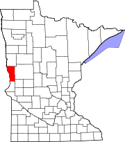
Rice Township is a township in Clearwater County, Minnesota, United States. The population was 134 at the 2000 census. Rice Township was named after the Wild Rice River.

Daggett Brook Township is a township in Crow Wing County, Minnesota, United States. The population was 448 at the 2000 census. This township took its name from Daggett Brook.

Steamboat River Township is a township in Hubbard County, Minnesota, United States. The population was 123 at the 2000 census.

Poppleton Township is a township in Kittson County, Minnesota, United States. The population was 123 at the 2000 census.

Bejou Township is a township in Mahnomen County, Minnesota, United States. The population was 98 at the 2000 census.

Chief Township is a township in Mahnomen County, Minnesota, United States. The population was 132 at the 2000 census.

Clover Township is a township in Mahnomen County, Minnesota, United States. The population was 123 at the 2000 census.

Star Lake Township is a township in Otter Tail County, Minnesota, United States. The population was 410 at the 2000 census.

Clover Township is a township in Pine County, Minnesota, United States. The population was 316 at the 2000 census.

Garfield Township is a township in Polk County, Minnesota, United States. It is part of the Grand Forks-ND-MN Metropolitan Statistical Area. The population was 391 at the 2000 census.

Equality Township is a township in Red Lake County, Minnesota, United States. The population was 123 at the 2000 census.

Hector Township is a township in Renville County, Minnesota, United States. The population was 248 at the 2000 census.

Palmville Township is a township in Roseau County, Minnesota, United States. The population was 55 at the 2000 census. The town was named for Louis Palm, a Swedish settler.

Arlington Township is a township in Sibley County, Minnesota, United States. The population was 562 at the 2000 census.

Lake George Township is a township in Stearns County, Minnesota, United States. The population was 335 at the 2010 census.

Lake Henry Township is a township in Stearns County, Minnesota, United States. The population was 278 at the 2010 census.

Cashel Township is a township in Swift County, Minnesota, United States. The population was 143 at the 2000 census.

Tyro Township is a township in Yellow Medicine County, Minnesota, United States. The population was 208 at the 2000 census.

References

  1. 1 2 "U.S. Census website". United States Census Bureau . Retrieved January 31, 2008.
  2. "US Board on Geographic Names". United States Geological Survey. October 25, 2007. Retrieved January 31, 2008.
  3. Upham, Warren (1920). Minnesota Geographic Names: Their Origin and Historic Significance. Minnesota Historical Society. p.  578.