Rothsay, Minnesota

Last updated
Rothsay
Rothsay, Minnesota.jpg
Otter Tail County Minnesota Incorporated and Unincorporated areas Rothsay Highlighted.svg
Location of Rothsay, Minnesota
Coordinates: 46°28′23″N96°17′03″W / 46.47306°N 96.28417°W / 46.47306; -96.28417
CountryUnited States
State Minnesota
Counties Wilkin, Otter Tail
Area
[1]
  Total0.86 sq mi (2.22 km2)
  Land0.86 sq mi (2.22 km2)
  Water0.00 sq mi (0.00 km2)
Elevation
[2]
1,188 ft (362 m)
Population
 (2020) [3]
  Total498
  Estimate 
(2021) [4]
491
  Density580.42/sq mi (224.14/km2)
Time zone UTC-6 (CST)
  Summer (DST) UTC-5 (CDT)
ZIP code
56579
Area code 218
FIPS code 27-56014
GNIS feature ID2396439 [2]

Rothsay is a city in Otter Tail and Wilkin counties in the State of Minnesota. The population was 498 at the 2020 census. [3] One of Rothsay's major tourist attractions is the large prairie chicken statue near the northwest outskirts of the town.

Contents

The Otter Tail County portion of Rothsay is part of the Fergus Falls Micropolitan Statistical Area, while the Wilkin County portion is part of the Wahpeton, ND—MN Micropolitan Statistical Area.

History

A post office called Rothsay has been in operation since 1880. [5] The city was named after Rothesay, in Scotland. [6] Rothsay contains one property listed on the National Register of Historic Places, the 1903 J. A. Johnson Blacksmith Shop. [7]

Geography

Rothsay Prairie Chicken Statue Rothsay.jpeg
Rothsay Prairie Chicken Statue

According to the United States Census Bureau, the city has a total area of 0.88 square miles (2.28 km2), all land. [8]

Interstate Highway 94/US Highway 52, Center Street, and Main Avenue are three of the main routes in the community.

Climate

Climate data for Rothsay, Minnesota (1991–2020 normals, extremes 1959–present)
MonthJanFebMarAprMayJunJulAugSepOctNovDecYear
Record high °F (°C)55
(13)
56
(13)
81
(27)
98
(37)
97
(36)
99
(37)
102
(39)
105
(41)
99
(37)
95
(35)
77
(25)
56
(13)
105
(41)
Average high °F (°C)18.2
(−7.7)
23.0
(−5.0)
36.3
(2.4)
52.7
(11.5)
66.9
(19.4)
75.8
(24.3)
80.0
(26.7)
78.4
(25.8)
70.3
(21.3)
54.7
(12.6)
38.0
(3.3)
24.1
(−4.4)
51.5
(10.8)
Daily mean °F (°C)8.7
(−12.9)
12.8
(−10.7)
26.8
(−2.9)
42.0
(5.6)
56.1
(13.4)
66.1
(18.9)
70.0
(21.1)
68.3
(20.2)
59.5
(15.3)
44.8
(7.1)
29.4
(−1.4)
15.6
(−9.1)
41.7
(5.4)
Average low °F (°C)−0.9
(−18.3)
2.6
(−16.3)
17.2
(−8.2)
31.3
(−0.4)
45.2
(7.3)
56.4
(13.6)
60.0
(15.6)
58.1
(14.5)
48.8
(9.3)
35.0
(1.7)
20.9
(−6.2)
7.1
(−13.8)
31.8
(−0.1)
Record low °F (°C)−39
(−39)
−37
(−38)
−26
(−32)
−5
(−21)
18
(−8)
32
(0)
40
(4)
35
(2)
20
(−7)
10
(−12)
−21
(−29)
−34
(−37)
−39
(−39)
Average precipitation inches (mm)0.75
(19)
0.63
(16)
1.08
(27)
2.06
(52)
3.27
(83)
3.93
(100)
3.43
(87)
2.72
(69)
2.75
(70)
2.34
(59)
0.92
(23)
0.89
(23)
24.77
(629)
Average snowfall inches (cm)11.4
(29)
7.7
(20)
7.2
(18)
4.1
(10)
0.0
(0.0)
0.0
(0.0)
0.0
(0.0)
0.0
(0.0)
0.0
(0.0)
1.6
(4.1)
6.9
(18)
10.7
(27)
49.6
(126)
Average precipitation days (≥ 0.01 in)5.55.56.36.910.211.510.18.38.78.54.77.093.2
Average snowy days (≥ 0.1 in)6.55.13.71.20.00.00.00.00.00.82.57.126.9
Source: NOAA [9] [10]

Demographics

Historical population
CensusPop.Note
1890 174
1900 29670.1%
1910 34315.9%
1920 39816.0%
1930 386−3.0%
1940 4157.5%
1950 53729.4%
1960 457−14.9%
1970 448−2.0%
1980 4766.3%
1990 433−9.0%
2000 49714.8%
2010 493−0.8%
2020 4981.0%
2021 (est.)491 [4] −1.4%
U.S. Decennial Census [11]
2020 Census [3]

2010 census

As of the census of 2010, there were 493 people, 211 households, and 140 families living in the city. The population density was 560.2 inhabitants per square mile (216.3/km2). There were 250 housing units at an average density of 284.1 per square mile (109.7/km2). The racial makeup of the city was 98.8% White, 0.8% Native American, and 0.4% Asian. Hispanic or Latino of any race were 0.2% of the population.

There were 211 households, of which 32.7% had children under the age of 18 living with them, 49.8% were married couples living together, 9.5% had a female householder with no husband present, 7.1% had a male householder with no wife present, and 33.6% were non-families. 28.4% of all households were made up of individuals, and 11.4% had someone living alone who was 65 years of age or older. The average household size was 2.34 and the average family size was 2.80.

The median age in the city was 37.1 years. 25.8% of residents were under the age of 18; 5.7% were between the ages of 18 and 24; 28.8% were from 25 to 44; 24% were from 45 to 64; and 15.8% were 65 years of age or older. The gender makeup of the city was 51.3% male and 48.7% female.

2000 census

As of the census of 2000, there were 497 people, 201 households, and 125 families living in the city. The population density was 123.5 inhabitants per square mile (47.7/km2). There were 231 housing units at an average density of 57.4 per square mile (22.2/km2). The racial makeup of the city was 97.59% White, 0.40% Native American, 1.01% from other races, and 1.01% from two or more races. Hispanic or Latino of any race were 1.01% of the population.

There were 201 households, out of which 35.3% had children under the age of 18 living with them, 51.2% were married couples living together, 9.5% had a female householder with no husband present, and 37.8% were non-families. 33.8% of all households were made up of individuals, and 20.4% had someone living alone who was 65 years of age or older. The average household size was 2.47 and the average family size was 3.20.

In the city, the population was spread out, with 28.4% under the age of 18, 8.9% from 18 to 24, 28.2% from 25 to 44, 15.7% from 45 to 64, and 18.9% who were 65 years of age or older. The median age was 35 years. For every 100 females, there were 89.0 males. For every 100 females age 18 and over, there were 88.4 males.

The median income for a household in the city was $31,058, and the median income for a family was $34,479. Males had a median income of $25,625 versus $19,286 for females. The per capita income for the city was $14,854. About 6.2% of families and 9.6% of the population were below the poverty line, including 16.8% of those under age 18 and 9.7% of those age 65 or over.

Related Research Articles

<span class="mw-page-title-main">Wilkin County, Minnesota</span> County in Minnesota, United States

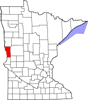
Wilkin County is a county in the U.S. state of Minnesota. As of the 2020 census, the population of Wilkin County was 6,506. Its county seat is Breckenridge. The county is named for Colonel Alexander Wilkin, a lawyer who served as Minnesota's U.S. marshal and was later killed in the Civil War.

Atherton Township is a township in Wilkin County, Minnesota, United States. The population was 155 at the 2000 census.

Bradford Township is a township in Wilkin County, Minnesota, United States. The population was 119 at the 2000 census.

<span class="mw-page-title-main">Breckenridge, Minnesota</span> City in Minnesota, United States

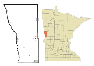
Breckenridge is a city and county seat of Wilkin County, Minnesota, United States. The population was 3,430 at the 2020 census.

Breckenridge Township is a township in Wilkin County, Minnesota, United States. The population was 234 at the 2000 census.

<span class="mw-page-title-main">Campbell, Minnesota</span> City in Minnesota, United States

Campbell is a city in Wilkin County, Minnesota, United States. The population was 164 at the 2020 census. It is part of the Wahpeton, ND-MN Micropolitan Statistical Area.

Campbell Township is a township in Wilkin County, Minnesota, United States. The population was 99 at the 2000 census.

<span class="mw-page-title-main">Doran, Minnesota</span> City in Minnesota, United States

Doran is a city in Wilkin County, Minnesota, United States. The population was 36 at the 2020 census. It is part of the Wahpeton, ND-MN Micropolitan Statistical Area.

<span class="mw-page-title-main">Foxhome, Minnesota</span> City in Minnesota, United States

Foxhome is a city in Wilkin County, Minnesota, United States. The population was 126 at the 2020 census. It is part of the Wahpeton, ND—MN Micropolitan Statistical Area.

<span class="mw-page-title-main">Kent, Minnesota</span> City in Minnesota, United States

Kent is a city in Wilkin County, Minnesota, United States. The population was 65 at the 2020 census. It is part of the Wahpeton, ND-MN Micropolitan Statistical Area.

McCauleyville Township is a township in Wilkin County, Minnesota, United States. The population was 56 at the 2000 census.

Meadows Township is a township in Wilkin County, Minnesota, United States. The population was 65 at the 2000 census.

Mitchell Township is a township in Wilkin County, Minnesota, United States. The population was 103 at the 2000 census.

<span class="mw-page-title-main">Nashua, Minnesota</span> City in Minnesota, United States

Nashua is a city in Wilkin County, Minnesota, United States. The population was 67 at the 2020 census. It is part of the Wahpeton, ND-MN Micropolitan Statistical Area.

Prairie View Township is a township in Wilkin County, Minnesota, United States. The population was 215 at the 2000 census.

Roberts Township is a township in Wilkin County, Minnesota, United States. The population was 118 at the 2000 census.

Sunnyside Township is a township in Wilkin County, Minnesota, United States. The population was 143 at the 2000 census.

Tanberg Township is a township in Wilkin County, Minnesota, United States. The population was 68 at the 2000 census.

<span class="mw-page-title-main">Wolverton, Minnesota</span> City in Minnesota, United States

Wolverton is a city in Wilkin County, Minnesota, United States. The population was 128 at the 2020 census. It is part of the Wahpeton, ND—MN Micropolitan Statistical Area.

Wolverton Township is a township in Wilkin County, Minnesota, United States. The population was 130 at the 2000 census.

References

  1. "2020 U.S. Gazetteer Files". United States Census Bureau. Retrieved July 24, 2022.
  2. 1 2 U.S. Geological Survey Geographic Names Information System: Rothsay, Minnesota
  3. 1 2 3 "Explore Census Data". United States Census Bureau . Retrieved May 1, 2022.
  4. 1 2 "City and Town Population Totals: 2020-2021". United States Census Bureau. June 19, 2022. Retrieved June 19, 2022.
  5. "Wilkin County". Jim Forte Postal History. Retrieved August 14, 2015.
  6. Upham, Warren (1920). Minnesota Geographic Names: Their Origin and Historic Significance. Minnesota Historical Society. p.  579.
  7. "Minnesota National Register Properties Database". Minnesota Historical Society. 2009. Retrieved December 26, 2017.
  8. "US Gazetteer files 2010". United States Census Bureau. Archived from the original on July 2, 2012. Retrieved November 13, 2012.
  9. "NowData - NOAA Online Weather Data". National Oceanic and Atmospheric Administration. Retrieved September 25, 2021.
  10. "Station: Rothsay, MN". U.S. Climate Normals 2020: U.S. Monthly Climate Normals (1991-2020). National Oceanic and Atmospheric Administration. Retrieved September 25, 2021.
  11. United States Census Bureau. "Census of Population and Housing" . Retrieved September 10, 2013.