Vergas, Minnesota

Last updated
Vergas
Otter Tail County Minnesota Incorporated and Unincorporated areas Vergas Highlighted.svg
Location of Vergas, Minnesota
Coordinates: 46°39′17″N95°48′11″W / 46.65472°N 95.80306°W / 46.65472; -95.80306
CountryUnited States
State Minnesota
County Otter Tail
Founded1903
Area
[1]
  Total1.61 sq mi (4.16 km2)
  Land1.57 sq mi (4.06 km2)
  Water0.04 sq mi (0.10 km2)
Elevation
[2]
1,411 ft (430 m)
Population
 (2020) [3]
  Total348
  Estimate 
(2021) [4]
348
  Density222.22/sq mi (85.81/km2)
Time zone UTC-6 (CST)
  Summer (DST) UTC-5 (CDT)
ZIP code
56587
Area code 218
FIPS code 27-66766 [5]
GNIS feature ID2397125 [2]
Website cityofvergas.com

Vergas is a city in northern Otter Tail County, Minnesota, United States. The population was 348 at the 2020 census. [3]

Contents

Vergas claims it is home of the World's Largest Loon, actually a 20-foot-high (6.1 m) sculpture of a loon, the Minnesota state bird.

Sign welcoming visitors to Vergas Vergas Minnesota welcome sign.jpg
Sign welcoming visitors to Vergas

History

The community was platted in 1903 as Altona, but quickly changed its name to match the name of its Soo Line Railroad station, which had been named after a series of sleeping cars that traveled between Minneapolis, Minnesota and Winnipeg, Manitoba. [6]

Geography

According to the United States Census Bureau, the city has a total area of 1.50 square miles (3.88 km2), of which 1.46 square miles (3.78 km2) is land and 0.04 square miles (0.10 km2) is water. [7]

Vergas is located at the junction of County Highway 4, County Highway 17, and former State Highway 228.

The community is at the west end of Long Lake.

Loon Lake is immediately southwest of Vergas.

Demographics

Historical population
CensusPop.Note
1910 237
1920 36152.3%
1930 323−10.5%
1940 3518.7%
1950 301−14.2%
1960 292−3.0%
1970 281−3.8%
1980 2872.1%
1990 2870.0%
2000 3118.4%
2010 3316.4%
2020 3485.1%
2021 (est.)348 [4] 0.0%
U.S. Decennial Census [8]
2020 Census [3]

2010 census

As of the census of 2010, there were 331 people, 176 households, and 88 families living in the city. The population density was 226.7 inhabitants per square mile (87.5/km2). There were 202 housing units at an average density of 138.4 per square mile (53.4/km2). The racial makeup of the city was 99.1% White, 0.3% African American, 0.3% from other races, and 0.3% from two or more races. Hispanic or Latino of any race were 0.3% of the population.

There were 176 households, of which 14.8% had children under the age of 18 living with them, 42.6% were married couples living together, 3.4% had a female householder with no husband present, 4.0% had a male householder with no wife present, and 50.0% were non-families. 42.6% of all households were made up of individuals, and 23.3% had someone living alone who was 65 years of age or older. The average household size was 1.88 and the average family size was 2.55.

The median age in the city was 52.5 years. 13.3% of residents were under the age of 18; 5.6% were between the ages of 18 and 24; 22.6% were from 25 to 44; 30.8% were from 45 to 64; and 27.5% were 65 years of age or older. The gender makeup of the city was 49.5% male and 50.5% female.

2000 census

As of the census of 2000, there were 311 people, 143 households, and 78 families living in the city. The population density was 213.9 inhabitants per square mile (82.6/km2). There were 165 housing units at an average density of 113.5 per square mile (43.8/km2). The racial makeup of the city was 97.75% White, 0.32% African American, 0.32% Native American, and 1.61% from two or more races. Hispanic or Latino of any race were 0.96% of the population.

There were 143 households, out of which 25.9% had children under the age of 18 living with them, 46.2% were married couples living together, 6.3% had a female householder with no husband present, and 44.8% were non-families. 38.5% of all households were made up of individuals, and 21.7% had someone living alone who was 65 years of age or older. The average household size was 2.17 and the average family size was 2.91.

In the city, the population was spread out, with 21.2% under the age of 18, 9.0% from 18 to 24, 23.5% from 25 to 44, 21.2% from 45 to 64, and 25.1% who were 65 years of age or older. The median age was 43 years. For every 100 females, there were 107.3 males. For every 100 females age 18 and over, there were 99.2 males.

The median income for a household in the city was $27,344, and the median income for a family was $37,250. Males had a median income of $23,214 versus $17,222 for females. The per capita income for the city was $14,461. About 4.7% of families and 7.9% of the population were below the poverty line, including none of those under age 18 and 19.7% of those age 65 or over.

The world's largest loon decorated for Christmas Vergas Minnesota loon.jpg
The world's largest loon decorated for Christmas

The Loon

The loon statue overlooks Long Lake. Standing 20 feet tall, the sculpture was built in the 1960s and paid for by the Vergas Fire Department, who dedicated it to a deceased town postmaster.

Related Research Articles

Balsam Township is a township in Aitkin County, Minnesota, United States. The population was 29 as of the 2020 census. The population in 2021 is estimated to be 29.

<span class="mw-page-title-main">Ramsey, Minnesota</span> City in Minnesota, United States

Ramsey is a suburb 22 miles north-northwest of downtown Minneapolis in Anoka County, Minnesota, United States. The population was 27,646 at the 2020 census. It is a northwest suburb of the Twin Cities.

<span class="mw-page-title-main">Taylor Township, Beltrami County, Minnesota</span> Township in Minnesota, United States

Taylor Township is a township in Beltrami County, Minnesota, United States. The population was 108 as of the 2000 census.

<span class="mw-page-title-main">Garden City Township, Blue Earth County, Minnesota</span> Township in Minnesota, United States

Garden City Township is a township in Blue Earth County, Minnesota, United States. The population was 700 as of the 2000 census.

<span class="mw-page-title-main">Ironton, Minnesota</span> City in Minnesota, United States

Ironton is a city in Crow Wing County, Minnesota, United States. The population was 572 at the 2010 census. It is part of the Brainerd Micropolitan Statistical Area.

<span class="mw-page-title-main">Oslo, Minnesota</span> City in Minnesota, United States

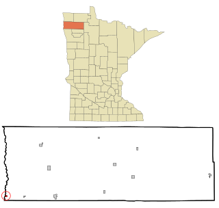
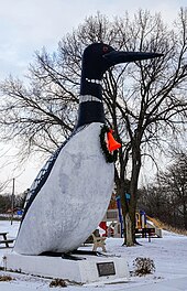
Oslo is a city in Marshall County, Minnesota, United States. The population was 239 at the 2020 census.

<span class="mw-page-title-main">Bluffton, Minnesota</span> City in Minnesota, United States

Bluffton is a city in Otter Tail County, Minnesota, United States, along the Leaf River. The population was 210 at the 2020 census.

<span class="mw-page-title-main">Deer Creek, Minnesota</span> City in Minnesota, United States

Deer Creek is a city in Otter Tail County, Minnesota, United States. The population was 330 at the 2020 census.

<span class="mw-page-title-main">Dent, Minnesota</span> City in Minnesota, United States

Dent is a city in Otter Tail County, Minnesota, United States. The population was 173 at the 2020 census.

Dora Township is a township in Otter Tail County, Minnesota, United States. The population was 697 at the 2020 census.

<span class="mw-page-title-main">Elizabeth, Minnesota</span> City in Minnesota, United States

Elizabeth is a city in Otter Tail County, Minnesota, United States. The population was 168 at the 2020 census.

<span class="mw-page-title-main">Erhard, Minnesota</span> City in Minnesota, United States

Erhard is a city in Otter Tail County, Minnesota, United States. The population was 132 at the 2020 census.

<span class="mw-page-title-main">Urbank, Minnesota</span> City in Minnesota, United States

Urbank is a city in Otter Tail County, Minnesota, United States. The population was 52 at the 2020 census.

<span class="mw-page-title-main">Orr, Minnesota</span> City in Minnesota, United States

Orr is a city in Saint Louis County, Minnesota, United States. The population was 211 at the 2020 census.

<span class="mw-page-title-main">Minnesota City, Minnesota</span> City in Minnesota, United States

Minnesota City is a city in Winona County, Minnesota, United States. The population was 202 at the 2020 census.

<span class="mw-page-title-main">Loon Lake Township, Cass County, Minnesota</span> Township in Minnesota, United States

Loon Lake Township is a township in Cass County, Minnesota, United States. The population was 376 as of the 2000 census. This township took its name from Loon Lake.

Maple Township is a township in Cass County, Minnesota, United States. The population was 291 as of the 2000 census. Maple Township was named from the groves of sugar maple trees within its borders.

<span class="mw-page-title-main">Minnesota Lake, Minnesota</span> City in Minnesota, United States

Minnesota Lake is a city in Blue Earth and Faribault counties in the State of Minnesota. The population was 661 at the 2020 census. The bulk of the city is in Faribault County; a small part extends into Blue Earth County.

<span class="mw-page-title-main">Dennison, Minnesota</span> City in Minnesota, United States

Dennison is a city in Goodhue and Rice counties in the U.S. state of Minnesota. The population was 212 at the 2010 census. Most of Dennison is in Goodhue County, with only a small part that extends into Rice County.

<span class="mw-page-title-main">Minneiska, Minnesota</span> City in Minnesota, United States

Minneiska is a city in Wabasha and Winona counties in the U.S. state of Minnesota. The population was 111 at the 2010 census.

References

  1. "2020 U.S. Gazetteer Files". United States Census Bureau. Retrieved July 24, 2022.
  2. 1 2 U.S. Geological Survey Geographic Names Information System: Vergas, Minnesota
  3. 1 2 3 "Explore Census Data". United States Census Bureau . Retrieved May 8, 2022.
  4. 1 2 "City and Town Population Totals: 2020-2021". United States Census Bureau. June 24, 2022. Retrieved June 24, 2022.
  5. "U.S. Census website". United States Census Bureau . Retrieved January 31, 2008.
  6. "Minnesota Place Names - Township and Village Information". Minnesota Historical Society. Retrieved April 18, 2011.
  7. "US Gazetteer files 2010". United States Census Bureau. Archived from the original on January 12, 2012. Retrieved November 13, 2012.
  8. "Census of Population and Housing". Census.gov. Retrieved June 4, 2015.