Elizabeth, Minnesota

Last updated

Elizabeth
Elizabeth Village Hall and Jail.jpg
Otter Tail County Minnesota Incorporated and Unincorporated areas Elizabeth Highlighted.svg
Location of Elizabeth, Minnesota
Coordinates: 46°22′45″N96°07′46″W / 46.37917°N 96.12944°W / 46.37917; -96.12944
CountryUnited States
State Minnesota
County Otter Tail
Founded1872
Area
[1]
  Total0.37 sq mi (0.97 km2)
  Land0.37 sq mi (0.97 km2)
  Water0.00 sq mi (0.00 km2)
Elevation
[2]
1,263 ft (385 m)
Population
 (2020) [3]
  Total168
  Estimate 
(2021) [4]
165
  Density450.40/sq mi (173.80/km2)
Time zone UTC-6 (CST)
  Summer (DST) UTC-5 (CDT)
ZIP code
56533
Area code 218
FIPS code 27-18566
GNIS feature ID2394646 [2]

Elizabeth is a city in Otter Tail County, Minnesota, United States. The population was 168 at the 2020 census. [3]

Contents

History

Elizabeth was platted in 1872, and named for Elizabeth Niggler, the wife of an early settler. [5] A post office was established under the name Elizabethtown in 1871, and the name was changed to Elizabeth in 1882. [6]

Geography

According to the United States Census Bureau, the city has a total area of 0.37 square miles (0.96 km2), all land. [7]

Demographics

Historical population
CensusPop.Note
1880 128
1890 1355.5%
1900 18637.8%
1910 169−9.1%
1920 20420.7%
1930 164−19.6%
1940 1767.3%
1950 168−4.5%
1960 1680.0%
1970 18811.9%
1980 1953.7%
1990 152−22.1%
2000 17213.2%
2010 1730.6%
2020 168−2.9%
2021 (est.)165 [4] −1.8%
U.S. Decennial Census [8]
2020 Census [3]

2010 census

As of the census of 2010, there were 173 people, 66 households, and 49 families living in the city. The population density was 467.6 inhabitants per square mile (180.5/km2). There were 84 housing units at an average density of 227.0 per square mile (87.6/km2). The racial makeup of the city was 93.6% White, 2.9% African American, 1.7% Native American, 0.6% Asian, and 1.2% from two or more races.

There were 66 households, of which 30.3% had children under the age of 18 living with them, 65.2% were married couples living together, 4.5% had a female householder with no husband present, 4.5% had a male householder with no wife present, and 25.8% were non-families. 19.7% of all households were made up of individuals, and 3% had someone living alone who was 65 years of age or older. The average household size was 2.62 and the average family size was 3.08.

The median age in the city was 43.8 years. 24.3% of residents were under the age of 18; 5.1% were between the ages of 18 and 24; 24.3% were from 25 to 44; 34.7% were from 45 to 64; and 11.6% were 65 years of age or older. The gender makeup of the city was 54.9% male and 45.1% female.

2000 census

As of the census of 2000, there were 172 people, 72 households, and 42 families living in the city. The population density was 473.5 inhabitants per square mile (182.8/km2). There were 85 housing units at an average density of 234.0 per square mile (90.3/km2). The racial makeup of the city was 98.26% White, 1.16% Native American, and 0.58% from two or more races.

There were 72 households, out of which 31.9% had children under the age of 18 living with them, 47.2% were married couples living together, 9.7% had a female householder with no husband present, and 40.3% were non-families. 30.6% of all households were made up of individuals, and 11.1% had someone living alone who was 65 years of age or older. The average household size was 2.39 and the average family size was 3.05.

In the city, the population was spread out, with 26.2% under the age of 18, 7.0% from 18 to 24, 31.4% from 25 to 44, 24.4% from 45 to 64, and 11.0% who were 65 years of age or older. The median age was 38 years. For every 100 females, there were 112.3 males. For every 100 females age 18 and over, there were 104.8 males.

The median income for a household in the city was $33,438, and the median income for a family was $38,333. Males had a median income of $28,750 versus $20,625 for females. The per capita income for the city was $13,841. About 2.1% of families and 8.0% of the population were below the poverty line, including 6.0% of those under the age of eighteen and none of those 65 or over.

Climate

The Köppen Climate Classification subtype for this climate is "Dfb". (Warm Summer Continental Climate). [9]

Climate data for Elizabeth, Minnesota
MonthJanFebMarAprMayJunJulAugSepOctNovDecYear
Average high °F (°C)17
(−8)
22
(−6)
36
(2)
54
(12)
68
(20)
77
(25)
82
(28)
81
(27)
70
(21)
57
(14)
37
(3)
23
(−5)
52
(11)
Average low °F (°C)−2
(−19)
3
(−16)
17
(−8)
32
(0)
45
(7)
55
(13)
60
(16)
57
(14)
48
(9)
36
(2)
21
(−6)
6
(−14)
32
(0)
Average precipitation inches (mm)0.9
(23)
0.7
(18)
1.2
(30)
2.1
(53)
3.0
(76)
4.2
(110)
3.4
(86)
3.0
(76)
2.4
(61)
1.7
(43)
1.1
(28)
0.7
(18)
24.3
(620)
Average precipitation days97891112999788106
Source: Weatherbase [10]

Related Research Articles

<span class="mw-page-title-main">Montevideo, Minnesota</span> City in Minnesota, United States

Montevideo is a city in Chippewa County, Minnesota, United States. The population was 5,398 at the 2020 census. It is the county seat of Chippewa County.

<span class="mw-page-title-main">Georgetown, Minnesota</span> City in Minnesota, United States

Georgetown is a city in Clay County, Minnesota, United States, along the Buffalo River near its confluence with the Red River of the North. The population was 86 at the 2020 census.

<span class="mw-page-title-main">Mabel, Minnesota</span> City in Minnesota, United States

Mabel is a city in Fillmore County, Minnesota, United States. The population was 780 at the 2010 census.

<span class="mw-page-title-main">Cohasset, Minnesota</span> City in Minnesota, United States

Cohasset is a city in Itasca County, Minnesota, United States. The population was 2,698 at the 2010 census.

<span class="mw-page-title-main">Hallock, Minnesota</span> City in Minnesota, United States

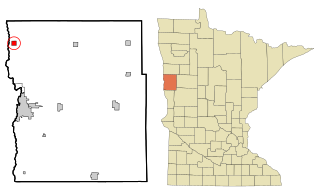
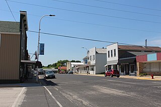
Hallock is a city in and the county seat of Kittson County, Minnesota, United States. The population was 906 at the 2020 census.

<span class="mw-page-title-main">Big Falls, Minnesota</span> City in Minnesota, United States

Big Falls is a city in Koochiching County, Minnesota, United States. The population was 175 at the 2020 census.

<span class="mw-page-title-main">Le Center, Minnesota</span> City in Minnesota, United States

Le Center is a city in Le Sueur County, Minnesota, United States. The population was 2,517 at the 2020 census. It is the county seat of Le Sueur County. The Le Sueur County Courthouse and Jail are listed on the National Register of Historic Places.

<span class="mw-page-title-main">Mahnomen, Minnesota</span> City in Minnesota, United States

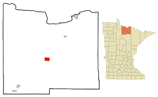
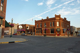
Mahnomen is a city in Mahnomen County, Minnesota, United States, along the Wild Rice River. The population was 1,214 at the 2010 census. It is the county seat of Mahnomen County.

<span class="mw-page-title-main">Stewartville, Minnesota</span> City in Minnesota, United States

Stewartville is a city in Olmsted County, Minnesota, United States. The population was 5,916 at the 2010 census, and was estimated to have grown to a population of 6,125 as of 2018. Stewartville has experienced growth as a result of its location just south of Rochester.

<span class="mw-page-title-main">Deer Creek, Minnesota</span> City in Minnesota, United States

Deer Creek is a city in Otter Tail County, Minnesota, United States. The population was 330 at the 2020 census.

<span class="mw-page-title-main">Erhard, Minnesota</span> City in Minnesota, United States

Erhard is a city in Otter Tail County, Minnesota, United States. The population was 132 at the 2020 census.

<span class="mw-page-title-main">Henning, Minnesota</span> City in Minnesota, United States

Henning is a city in Otter Tail County, Minnesota, United States. The population was 854 at the 2020 census.

<span class="mw-page-title-main">Ottertail, Minnesota</span> City in Minnesota, United States

Ottertail is a city in Otter Tail County, Minnesota, United States. The population was 629 at the 2020 census.

<span class="mw-page-title-main">Gaylord, Minnesota</span> City in Minnesota, United States

Gaylord is a city and the county seat of Sibley County, Minnesota, United States, along the shore of Titlow Lake. It is approximately 65 miles (105 km) west-southwest of Minneapolis-St. Paul. The population was 2,305 at the 2010 census.

<span class="mw-page-title-main">Winton, Minnesota</span> City in Minnesota, United States

Winton is a city in Saint Louis County, Minnesota, United States. The population was 172 at the 2010 census. The city is home to a small hydroelectric dam on the edge of Garden Lake, one of 11 stations owned by Minnesota Power.

<span class="mw-page-title-main">Wheaton, Minnesota</span> City in Minnesota, United States

Wheaton is a city in Traverse County, Minnesota, United States. The population was 1,460 at the 2020 census. It is the county seat.

<span class="mw-page-title-main">Elgin, Minnesota</span> City in Minnesota, United States

Elgin is a city in Wabasha County, Minnesota, United States on Minnesota State Highway 42. The population was 1,089 at the 2010 census. Its annual festival is Elgin Cheese Days.

<span class="mw-page-title-main">Elizabeth, West Virginia</span> Town in West Virginia, United States

Elizabeth is a town in and the county seat of Wirt County, West Virginia, United States, situated along the Little Kanawha River. The population was 724 as of the 2020 census.

<span class="mw-page-title-main">Minnesota Lake, Minnesota</span> City in Minnesota, United States

Minnesota Lake is a city in Blue Earth and Faribault counties in the State of Minnesota. The population was 661 at the 2020 census. The bulk of the city is in Faribault County; a small part extends into Blue Earth County.

<span class="mw-page-title-main">Rothsay, Minnesota</span> City in Minnesota, United States

Rothsay is a city in Otter Tail and Wilkin counties in the State of Minnesota. The population was 498 at the 2020 census. One of Rothsay's major tourist attractions is the large prairie chicken statue near the northwest outskirts of the town.

References

  1. "2020 U.S. Gazetteer Files". United States Census Bureau. Retrieved July 24, 2022.
  2. 1 2 U.S. Geological Survey Geographic Names Information System: Elizabeth, Minnesota
  3. 1 2 3 "Explore Census Data". United States Census Bureau . Retrieved May 6, 2022.
  4. 1 2 "City and Town Population Totals: 2020-2021". United States Census Bureau. June 24, 2022. Retrieved June 24, 2022.
  5. Upham, Warren (1920). Minnesota Geographic Names: Their Origin and Historic Significance. Minnesota Historical Society. p.  394.
  6. "Otter Tail County". Jim Forte Postal History. Archived from the original on March 2, 2016. Retrieved July 28, 2015.
  7. "US Gazetteer files 2010". United States Census Bureau. Archived from the original on January 25, 2012. Retrieved November 13, 2012.
  8. United States Census Bureau. "Census of Population and Housing" . Retrieved February 12, 2014.
  9. Climate Summary for Elizabeth, Minnesota
  10. "Weatherbase.com". Weatherbase. 2013. Retrieved on June 16, 2013.