Parkers Prairie, Minnesota

Last updated
Parkers Prairie
City
Otter Tail County Minnesota Incorporated and Unincorporated areas Parkers Prairie Highlighted.svg
Location of Parkers Prairie
within Otter Tail County, Minnesota
Coordinates: 46°09′11″N95°19′44″W / 46.15306°N 95.32889°W / 46.15306; -95.32889
CountryUnited States
State Minnesota
County Otter Tail
Founded1880
Area
[1]
  Total1.25 sq mi (3.24 km2)
  Land1.25 sq mi (3.23 km2)
  Water0.01 sq mi (0.02 km2)
Elevation
[2]
1,467 ft (447 m)
Population
 (2020) [3]
  Total1,020
  Estimate 
(2021) [4]
1,009
  Density819.28/sq mi (316.24/km2)
Time zone UTC-6 (CST)
  Summer (DST) UTC-5 (CDT)
ZIP code
56361
Area code 218
FIPS code 27-49732
GNIS feature ID2396151 [2]
Website parkersprairie.net

Parkers Prairie is a city in Otter Tail County, Minnesota, United States. The population was 1,020 at the 2020 census. [3]

Contents

History

Parkers Prairie was platted in 1880, some ten years after its namesake Parkers Prairie Township. [5] The city was incorporated in 1903. [5]

Geography

According to the United States Census Bureau, the city has a total area of 1.23 square miles (3.19 km2), of which 1.22 square miles (3.16 km2) is land and 0.01 square miles (0.03 km2) is water. [6]

Minnesota State Highway 29 and Otter Tail County Road 38 are two of the main routes in the community.

Demographics

Historical population
CensusPop.Note
1910 383
1920 57048.8%
1930 63110.7%
1940 78123.8%
1950 90015.2%
1960 884−1.8%
1970 882−0.2%
1980 9174.0%
1990 9564.3%
2000 9913.7%
2010 1,0112.0%
2020 1,0200.9%
2021 (est.)1,009 [4] −1.1%
U.S. Decennial Census [7]
2020 Census [3]

2010 census

As of the census of 2010, there were 1,011 people, 428 households, and 248 families living in the city. The population density was 828.7 inhabitants per square mile (320.0/km2). There were 464 housing units at an average density of 380.3 per square mile (146.8/km2). The racial makeup of the city was 99.2% White, 0.4% African American, 0.1% Native American, 0.1% from other races, and 0.2% from two or more races. Hispanic or Latino of any race were 0.4% of the population.

There were 428 households, of which 28.3% had children under the age of 18 living with them, 44.9% were married couples living together, 9.6% had a female householder with no husband present, 3.5% had a male householder with no wife present, and 42.1% were non-families. 38.3% of all households were made up of individuals, and 23.9% had someone living alone who was 65 years of age or older. The average household size was 2.20 and the average family size was 2.90.

The median age in the city was 46.6 years. 24% of residents were under the age of 18; 5.7% were between the ages of 18 and 24; 18.7% were from 25 to 44; 21% were from 45 to 64; and 30.3% were 65 years of age or older. The gender makeup of the city was 45.7% male and 54.3% female.

2000 census

As of the census of 2000, there were 991 people, 401 households, and 240 families living in the town. The population density was 841.8 inhabitants per square mile (325.0/km2). There were 442 housing units at an average density of 375.4 per square mile (144.9/km2). The racial makeup of the town was 99.39% White, 0.10% Asian, 0.10% from other races, and 0.40% from two or more races. Hispanic or Latino of any race were 0.61% of the population.

There were 401 households, out of which 25.4% had children under the age of 18 living with them, 50.6% were married couples living together, 7.5% had a female householder with no husband present, and 40.1% were non-families. 34.7% of all households were made up of individuals, and 23.2% had someone living alone who was 65 years of age or older. The average household size was 2.22 and the average family size was 2.88.

In the town the population was spread out, with 20.8% under the age of 18, 6.0% from 18 to 24, 22.9% from 25 to 44, 20.7% from 45 to 64, and 29.7% who were 65 years of age or older. The median age was 45 years. For every 100 females, there were 90.9 males. For every 100 females age 18 and over, there were 85.1 males.

The median income for a household in the town was $28,618, and the median income for a family was $36,042. Males had a median income of $28,068 versus $19,250 for females. The per capita income for the town was $16,748. About 6.0% of families and 12.2% of the population were below the poverty line, including 13.6% of those under age 18 and 16.3% of those age 65 or over.

Industry

Parkers Prairie has a number of different primary and secondary industries, from machine parts manufacture to arable produce processing. The high-tech medical device company AbbeyMoor Medical has its head office and manufacturing plant in Parkers Prairie. AbbeyMoor Medical manufactures The Spanner, a prostatic stent.

Notable people

Related Research Articles

<span class="mw-page-title-main">Parker, Kansas</span> City in Kansas, United States

Parker is a city in Linn County, Kansas, United States. As of the 2020 census, the population of the city was 241.

<span class="mw-page-title-main">Fontana, Kansas</span> City in Kansas, United States

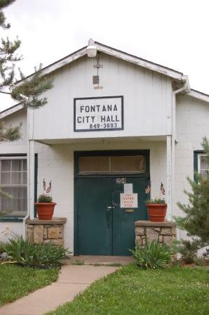
Fontana is a city in south central Miami County, Kansas, United States, and is part of the Kansas City metropolitan area. As of the 2020 census, the population of the city was 210. The name Fontana comes from the French word fontaine, meaning fountain or a spring-like water source. It was given to the small city from a spring near the town site. Fontana's history as a community dates back to the early 19th century, however incorporation did not occur until 1889.

<span class="mw-page-title-main">Sunfish Lake, Minnesota</span> City in Minnesota, United States

Sunfish Lake is a city in Dakota County, Minnesota, United States. The population was 521 at the 2010 census. First incorporated as a village in 1958, the city's goal has been to maintain a rural atmosphere, with large lot size and as little disturbance of the natural environment as possible.

Mound Prairie Township is a township in Houston County, Minnesota, United States. The population was 661 at the 2000 census.

<span class="mw-page-title-main">La Prairie, Minnesota</span> City in Minnesota, United States

La Prairie is a city in Itasca County, Minnesota, United States. The population was 665 at the 2010 census.

<span class="mw-page-title-main">Tyler, Minnesota</span> City in Minnesota, United States

Tyler is a city in Lincoln County, Minnesota, United States. The population in was 1,143 at the 2010 census.

Scandia Valley Township is a township in Morrison County, Minnesota, United States. The population was 1,074 at the 2000 census. According to the U. S. Census Bureau it was merged with Rail Prairie Township on 31 December 2002. The larger township reported a population of 1,191 inhabitants in the 2010 census.

Dane Prairie Township is a township in Otter Tail County, Minnesota, United States. The population was 892 at the 2000 census.

<span class="mw-page-title-main">Deer Creek, Minnesota</span> City in Minnesota, United States

Deer Creek is a city in Otter Tail County, Minnesota, United States. The population was 330 at the 2020 census.

<span class="mw-page-title-main">Henning, Minnesota</span> City in Minnesota, United States

Henning is a city in Otter Tail County, Minnesota, United States. The population was 854 at the 2020 census.

Parkers Prairie Township is a township in Otter Tail County, Minnesota, United States. The population was 345 at the 2000 census.

Maine Prairie Township is a township in Stearns County, Minnesota, United States. The population was 1,887 at the 2010 census.

Blooming Prairie Township is a township in Steele County, Minnesota, United States. The population was 519 at the 2000 census.

<span class="mw-page-title-main">Long Prairie, Minnesota</span> County seat and city in Minnesota, United States

Long Prairie is a town in Todd County, Minnesota, United States. The population was 3,458 at the 2010 census. It is the county seat. and the oldest town in the County.

Long Prairie Township is a township in Todd County, Minnesota, United States. The population was 823 at the 2000 census and 884 in the 2020 census.

<span class="mw-page-title-main">Wabasha, Minnesota</span> City in Minnesota, United States

Wabasha is a city and the county seat of Wabasha County, Minnesota. The population was 2,559 at the time of the 2020 census. It is on the Mississippi River, near its confluence with the Zumbro River.

<span class="mw-page-title-main">North Mankato, Minnesota</span> City in Minnesota, United States

North Mankato is a city in Nicollet and Blue Earth counties in the State of Minnesota. The population was 14,275 at the 2020 census.

<span class="mw-page-title-main">Motley, Minnesota</span> City in Minnesota, United States

Motley is a city in Cass and Morrison counties in the U.S. state of Minnesota. The population was 680 at the 2020 census. The main part of Motley is located within Morrison County; only a minor part of the city extends into Cass County

<span class="mw-page-title-main">Blooming Prairie, Minnesota</span> City in Minnesota, United States

Blooming Prairie is a city in Dodge and Steele counties in the U.S. state of Minnesota. The population was 1,996 at the 2010 census. Most of the city is located within Steele County; only a small part of the city extends into Dodge County.

<span class="mw-page-title-main">Rothsay, Minnesota</span> City in Minnesota, United States

Rothsay is a city in Otter Tail and Wilkin counties in the State of Minnesota. The population was 498 at the 2020 census. One of Rothsay's major tourist attractions is the large prairie chicken statue near the northwest outskirts of the town.

References

  1. "2020 U.S. Gazetteer Files". United States Census Bureau. Retrieved July 24, 2022.
  2. 1 2 U.S. Geological Survey Geographic Names Information System: Parkers Prairie, Minnesota
  3. 1 2 3 "Explore Census Data". United States Census Bureau . Retrieved May 6, 2022.
  4. 1 2 "City and Town Population Totals: 2020-2021". United States Census Bureau. June 24, 2022. Retrieved June 24, 2022.
  5. 1 2 Upham, Warren (1920). Minnesota Geographic Names: Their Origin and Historic Significance. Minnesota Historical Society. p.  397.
  6. "US Gazetteer files 2010". United States Census Bureau. Archived from the original on January 12, 2012. Retrieved November 13, 2012.
  7. United States Census Bureau. "Census of Population and Housing" . Retrieved September 10, 2013.