Continental shelf of Russia

Last updated

The continental shelf of Russia (also called the Russian continental shelf or the Arctic shelf in the Arctic region) is a continental shelf adjacent to the Russian Federation. Geologically, the extent of the shelf is defined as the entirety of the continental shelves adjacent to Russia's coast. In international law, however, the United Nations Convention on the Law of the Sea more narrowly defines the extent of the shelf as the seabed and subsoil of the submarine areas over which a state exercises sovereign rights.

Contents

The Siberian Shelf in the Arctic Ocean is the largest (and least explored) of the Russian shelves, a region of strategic importance because of its oil and natural gas reserves. [1] Other parts of the Russian shelf are typically named after the corresponding seas: Barents Shelf (Barents Sea Shelf), Chukchi Shelf (Chukchi Sea Shelf), etc. With the exception of internal Russian seas, these geological shelves are shared with other countries which share the corresponding seas. For example, the Chukchi Shelf is shared between Russia and the United States according to the 1990 USA-USSR maritime boundary.

2001 extension claim

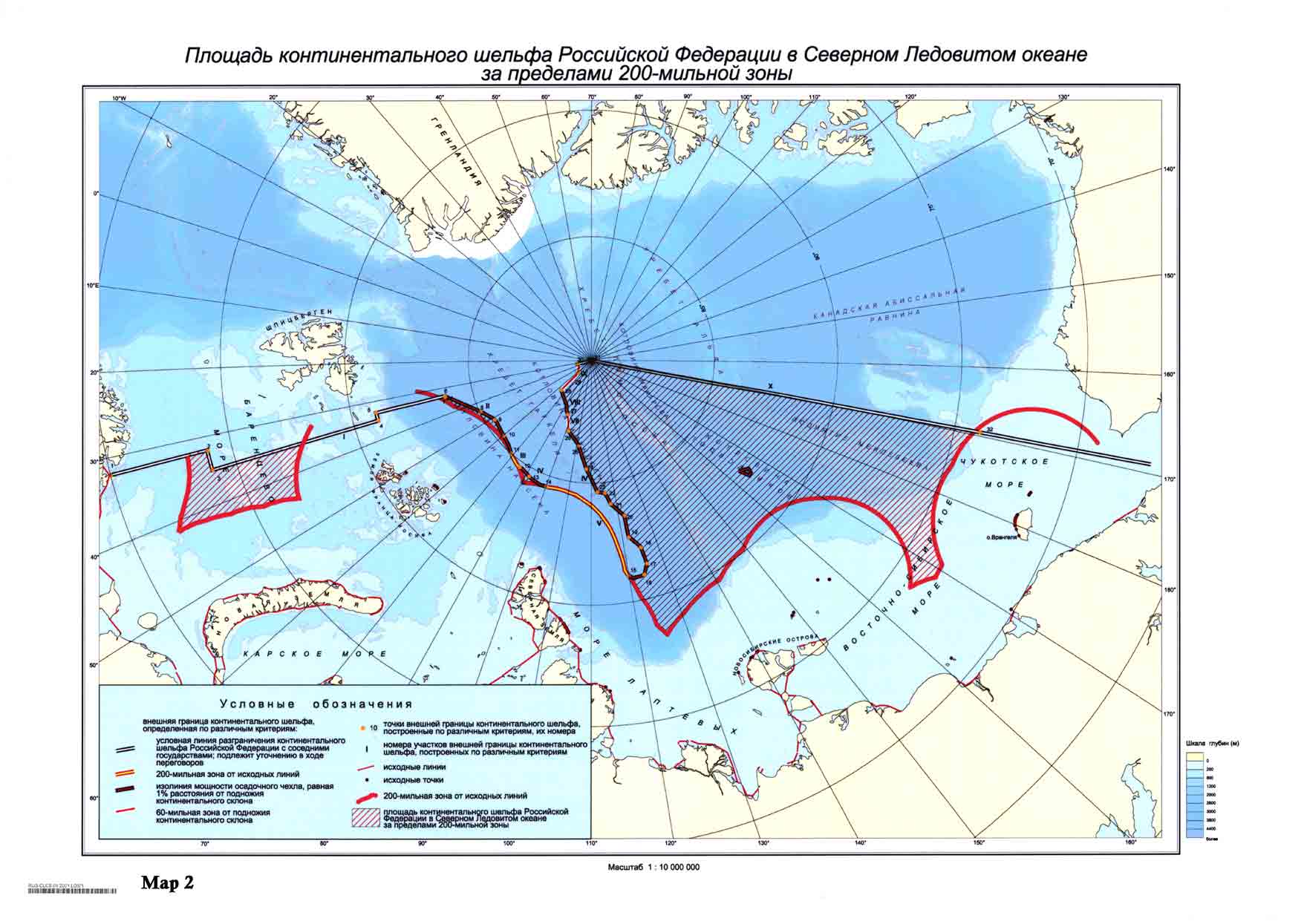
On 20 December 2001, Russia made an official submission into the UN Commission on the Limits of the Continental Shelf in accordance with the United Nations Convention on the Law of the Sea (article 76, paragraph 8). In the document it is proposed to establish new outer limits of the continental shelf of Russia beyond the previous 200 nautical mile zone (370 km), but within the Russian Arctic sector. [2] The territory claimed by Russia in the submission is a large portion of the Arctic within Russia's sector and extending to the North Pole. [3] One of the arguments was a statement that eastern portion of the Lomonosov Ridge, an underwater mountain ridge extending across the polar basin, and the Mendeleev Ridge are extensions of the Eurasian continent. In 2002, the UN Commission requested that Russia submit additional scientific evidence in support of its claim.

Additional research

Additional research for the Russian claim was planned over 20072008 as part of the Russian program for the International Polar Year. The program investigated the structure and evolution of the Earth's crust in the Arctic regions neighbouring Eurasia, such as the regions of Mendeleev Ridge, Alpha Ridge, and Lomonosov Ridge, to discover whether they were linked with the Siberian shelf. Major means of research during the expedition were the Akademik Fedorov research ship, the Russia nuclear icebreaker with two helicopters and geological probe devices, and Il-18 aircraft with gravimetric devices. [4] [5]

In June 2007, a group of 50 Russian scientists returned from a six-week expedition on the Russia with the news that the Lomonosov Ridge was linked to Russian Federation territory, supporting Russia's claim over the oil-and-gas rich triangle. [6] The territory contained 10 billion tonnes of gas and oil deposits, the scientists said. [7] Russian President Vladimir Putin then used this information to restate the 2001 Russian claim.[ citation needed ]

On 2 August 2007, Russian explorers in a submersible planted the national flag on the seabed below the North Pole in symbolic support of the 2001 claim. A mechanical arm dropped a specially made rust-proof titanium flag onto the Arctic seabed at a depth of 4,261 metres (13,980 ft). [8]

International reaction

In response to Russia's planting the national flag on the seabed at the North Pole, Canadian Foreign Minister Peter MacKay said, "This isn't the 15th century. You can't go around the world and just plant flags and say 'We're claiming this territory'". In response to these words the Foreign Minister of the Russian Federation Sergey Lavrov stated: "I was amazed by my Canadian counterpart's statement that we are planting flags around. We’re not throwing flags around. We just do what other discoverers did. The purpose of the expedition is not to stake whatever rights of Russia, but to prove that our shelf extends to the North Pole and beyond". [9]

Research results

In mid-September 2007, Russia's Natural Resources Ministry issued a statement:

Preliminary results of an analysis of the earth crust model examined by the Arktika 2007 expedition, obtained on 20 September, have confirmed that the crust structure of the Lomonosov Ridge corresponds to the world analogues of the continental crust, and it is therefore part of the Russian Federation's adjacent continental shelf. [10]

On 4 August 2015, Russia submitted additional data in support of its bid, containing new arguments based on "ample scientific data collected in years of Arctic research", for territories in the Arctic to the United Nations. Through this bid, Russia is claiming 1.2 million square kilometers (over 463,000 square miles) of Arctic sea shelf extending more than 350 nautical miles (about 650 kilometers) from the shore. [11]

On 9 February 2016, Russia formally submitted to the United Nations a revised application with substantiated evidence of shelf claims to the Arctic Ocean seabed, including an area under the North Pole. [12]

The evidential base of this application includes geology and geophysics evidence from nine Russian scientific expeditions. They were launched by Ministry of natural resources and environmental protection in cooperation with the Ministry of Defence and Russian Academy of Sciences. It is important to note that the expeditions were performed by scientific icebreakers and submarines. Moreover, a geological office has conducted acquisitions of bathymetric multibeam sounder, integrated seismic exploration, airborne geophysical measurements and geological sampling of the main Amerasian and Eurasian basins' structures. During the work researchers used a unique technology, specially designed for difficult ice conditions. The icebreaking research vessel Akademik Fedorov was refitted specifically for seismic operations in ice thickness up to three meters. [13]

The justification of Russian claim is confirmed by the continuity of the sedimentary magnitude, elements of basal complex, as well as the overall continuity and consistency of the deep layers of the earth's crust and the absence of strike-slip transverse faults at the junction of the Lomonosov Ridge and the Eurasian continent. [14]

All collected data show the continental character of the Lomonosov Ridge, the Mendeleev-Alfa High, the Chukotka Plateau, as well as the continuous extension of these elements from the shallow Eurasian shelf. [15]

On August 9, 2016, all of this evidence were presented in New York at the 41st session of the UN Commission on the Limits of the Continental Shelf (CLCS).

See also

Related Research Articles

<span class="mw-page-title-main">North Pole</span> Northern point where the Earths axis of rotation intersects its surface

The North Pole, also known as the Geographic North Pole or Terrestrial North Pole, is the point in the Northern Hemisphere where the Earth's axis of rotation meets its surface. It is called the True North Pole to distinguish from the Magnetic North Pole.

<span class="mw-page-title-main">Arctic</span> Polar region of the Earths northern hemisphere

The Arctic is a polar region located at the northernmost part of Earth. The Arctic consists of the Arctic Ocean, adjacent seas, and parts of Canada, Danish Realm (Greenland), northern Finland (Lapland), Iceland, northern Norway, Russia, northernmost Sweden and the United States (Alaska). Land within the Arctic region has seasonally varying snow and ice cover, with predominantly treeless permafrost containing tundra. Arctic seas contain seasonal sea ice in many places.

<span class="mw-page-title-main">Barents Sea</span> Marginal sea of the Arctic Ocean, off the northern coasts of Norway and Russia

The Barents Sea is a marginal sea of the Arctic Ocean, located off the northern coasts of Norway and Russia and divided between Norwegian and Russian territorial waters. It was known among Russians in the Middle Ages as the Murman Sea ; the current name of the sea is after the historical Dutch navigator Willem Barentsz.

<span class="mw-page-title-main">Chukchi Sea</span> Marginal sea of the Arctic Ocean north of the Bering Strait

Chukchi Sea, sometimes referred to as the Chuuk Sea, Chukotsk Sea or the Sea of Chukotsk, is a marginal sea of the Arctic Ocean. It is bounded on the west by the Long Strait, off Wrangel Island, and in the east by Point Barrow, Alaska, beyond which lies the Beaufort Sea. The Bering Strait forms its southernmost limit and connects it to the Bering Sea and the Pacific Ocean. The principal port on the Chukchi Sea is Uelen in Russia. The International Date Line crosses the Chukchi Sea from northwest to southeast. It is displaced eastwards to avoid Wrangel Island as well as the Chukotka Autonomous Okrug on the Russian mainland.

Arctica or Arctida was an ancient continent which formed approximately 2.565 billion years ago in the Neoarchean era. It was made of Archaean cratons, including the Siberian Craton, with its Anabar/Aldan shields in Siberia, and the Slave, Wyoming, Superior, and North Atlantic cratons in North America. Arctica was named by Rogers 1996 because the Arctic Ocean formed by the separation of the North American and Siberian cratons. Russian geologists writing in English call the continent "Arctida" since it was given that name in 1987, alternatively the Hyperborean craton, in reference to the hyperboreans in Greek mythology.

<span class="mw-page-title-main">Lomonosov Ridge</span> Underwater ridge of continental crust in the Arctic Ocean

The Lomonosov Ridge is an unusual underwater ridge of continental crust in the Arctic Ocean. It spans 1,800 kilometres (1,100 mi) between the New Siberian Islands over the central part of the ocean to Ellesmere Island of the Canadian Arctic Archipelago. The ridge divides the Arctic Basin into the Eurasian Basin and the Amerasian Basin. The width of the Lomonosov Ridge varies from 60 to 200 kilometres. It rises 3,300 to 3,700 metres above the 4,200-metre (13,800 ft) deep seabed. The minimum depth of the ocean above the ridge is less than 400 metres (1,300 ft). Slopes of the ridge are relatively steep, broken up by canyons, and covered with layers of silt. It is an aseismic ridge.

<span class="mw-page-title-main">Herald Island (Arctic)</span>

Herald Island is a small, isolated Russian island in the Chukchi Sea, 60 kilometres east of Waring Point, Wrangel Island. It rises in sheer cliffs, making it quite inaccessible, either by ship or by plane. The only bit of accessible shoreline is at its northwestern point, where the cliffs have crumbled into piles of loose rocks and gravel. Its area is 11.3 km2 and the maximum height above sea level is 364 m (1,194 ft). The island is unglaciated and uninhabited.

<span class="mw-page-title-main">Petroleum exploration in the Arctic</span> Industry in the Arctic

The exploration of the Arctic for petroleum is considered to be quite technically challenging. However, recent technological developments, the melting of Arctic permafrost, as well as relatively high oil prices, have allowed for exploration. As a result, the region has received significant interest from the petroleum industry.

<span class="mw-page-title-main">Territorial claims in the Arctic</span>

The Arctic consists of land, internal waters, territorial seas, exclusive economic zones (EEZs) and international waters above the Arctic Circle. All land, internal waters, territorial seas and EEZs in the Arctic are under the jurisdiction of one of the eight Arctic coastal states: Canada, Denmark, Finland, Iceland, Norway, Russia, Sweden and the United States. International law regulates this area as with other portions of Earth.

<span class="mw-page-title-main">Mendeleev Ridge</span> Broad ridge in the Arctic Ocean from the Siberian Shelf to the central areas of the ocean

The Mendeleev Ridge is a broad ridge in the Arctic Ocean from the East Siberian Sea area of the Siberian Shelf to the central areas of the ocean. It is attached to the Alpha Ridge of the Amerasian Basin. It is named after Dmitri Mendeleyev.The Ridge was discovered in 1948 by Soviet high latitude expeditions. The name was approved by the Sub-Committee on Geographical Names and Nomenclature of Ocean Bottom Features in April 1987.

<span class="mw-page-title-main">Siberian Shelf</span>

The Siberian Shelf is a coastal shelf in the Arctic Ocean and is the largest continental shelf of the Earth, a part of the continental shelf of Russia. It extends from the continent of Eurasia in the general area of North Siberia into the Arctic Ocean. It stretches to 1,500 kilometers (930 mi) offshore. It is relatively shallow, with average depth of 100 m. A number of islands are within the shelf, including the Wrangel Island, Novaya Zemlya, and the New Siberian Islands.

<span class="mw-page-title-main">Arktika 2007</span> Russian expedition involving a crewed descent to the ocean bottom at the North Pole

Arktika 2007 was a 2007 expedition in which Russia performed the first ever crewed descent to the ocean bottom at the North Pole, as part of research related to the 2001 Russian territorial claim, one of many territorial claims in the Arctic, made possible, in part, because of Arctic shrinkage. As well as dropping a titanium tube containing the Russian flag, the submersibles collected specimens of Arctic flora and fauna and apparently recorded video of the dives. The "North Pole-35" manned drifting ice station was established.

<i>Akademik Fedorov</i>

RV Akademik Fedorov is a Russian scientific diesel-electric research vessel, the flagship of the Russian polar research fleet. It was built in Rauma, Finland for the Soviet Union and completed on 8 September 1987. It started operations on 24 October 1987, in the USSR. The ship was named after a Soviet polar explorer, academician of the USSR Academy of Sciences Evgeny Fyodorov, who worked on the first Soviet manned drifting ice station North Pole-1.

<span class="mw-page-title-main">Eurasian Basin</span>

The Eurasian Basin, or Eurasia Basin, is one of the two major basins into which the Arctic Basin of the Arctic Ocean is split by the Lomonosov Ridge. The Eurasia Basin may be seen as an extension of the North Atlantic Basin through Fram Strait. It is further split by the mid-ocean Gakkel Ridge into the Nansen Basin and the Amundsen Basin. The latter basin is the deepest one of the Arctic Ocean and the geographic North Pole is located there.

<span class="mw-page-title-main">Amerasia Basin</span> Basin

The Amerasia Basin, or Amerasian Basin, is one of the two major basins from which the Arctic Ocean can be subdivided. The triangular-shaped Amerasia Basin broadly extends from the Canadian Arctic Islands to the East Siberian Sea, and from Alaska to the Lomonosov Ridge. The basin can be further subdivided based on bathymetric features; these include the Canada Basin, the Makarov Basin, the Podvodnikov Basin, the Alpha-Mendeleev Ridge, and the Chukchi Plateau.

<span class="mw-page-title-main">Arctic Ocean</span> Ocean in the north polar region

The Arctic Ocean is the smallest and shallowest of the world's five major oceans. It spans an area of approximately 14,060,000 km2 (5,430,000 sq mi) and is known as the coldest of all the oceans. The International Hydrographic Organization (IHO) recognizes it as an ocean, although some oceanographers call it the Arctic Mediterranean Sea. It has been described approximately as an estuary of the Atlantic Ocean. It is also seen as the northernmost part of the all-encompassing World Ocean.

<span class="mw-page-title-main">Arctic cooperation and politics</span> Between the eight Arctic nations

Arctic cooperation and politics are partially coordinated via the Arctic Council, composed of the eight Arctic nations: the United States, Canada, Iceland, Norway, Sweden, Finland, Russia, and Denmark with Greenland and the Faroe Islands. The dominant governmental power in Arctic policy resides within the executive offices, legislative bodies, and implementing agencies of the eight Arctic nations, and to a lesser extent other nations, such as United Kingdom, Germany, European Union and China. NGOs and academia play a large part in Arctic policy. Also important are intergovernmental bodies such as the United Nations and NATO.

<span class="mw-page-title-main">Arctic policy of Russia</span> Russia and the Arctic

The Arctic policy of Russia is the domestic and foreign policy of the Russian Federation with respect to the Russian region of the Arctic. The Russian region of the Arctic is defined in the "Russian Arctic Policy" as all Russian possessions located north of the Arctic Circle. Approximately one-fifth of Russia's landmass is north of the Arctic Circle. Russia is one of five littoral states bordering the Arctic Ocean. As of 2010, out of 4 million inhabitants of the Arctic, roughly 2 million lived in arctic Russia, making it the largest arctic country by population. However, in recent years Russia's Arctic population has been declining.

<span class="mw-page-title-main">Chukchi Plateau</span> A large subsea formation extending north from the Alaskan margin into the Arctic Ocean

The Chukchi Plateau or Chukchi Cap is a large subsea formation extending north from the Alaskan margin into the Arctic Ocean. The ridge is normally covered by ice year-round, and reaches an approximate bathymetric prominence of 3,400 m with its highest point at 246 m below sea level. As a subsea ridge extending from the continental shelf of the United States north of Alaska, the Chukchi Plateau is an important feature in maritime law of the Arctic Ocean and has been the subject of significant geographic research. The ridge has been extensively mapped by the USCGC Healy, and by the Canadian icebreaker CCGS Louis S. St-Laurent in 2011 and RV Marcus Langseth, a National Science Foundation vessel operated by the Lamont–Doherty Earth Observatory of Columbia University.

<span class="mw-page-title-main">Geopolitics of the Arctic</span>

Arctic geopolitics is the area study of geopolitics on the Arctic region. The study of geopolitics deals with the "inalienable relationship between geography and politics", as it investigates the effects of the Earth's geography on politics and international relations. Arctic geopolitics focuses on the inter-state relations in the Arctic, which is the northernmost polar region. It is composed of the Arctic Ocean and its adjacent seas, and is home to around four million people. The states in or bordering the Arctic are commonly referred to as the Arctic Eight, and are the United States, Canada, Russia, Finland, the Kingdom of Denmark (Greenland), Norway, Iceland and Sweden.

References

  1. The Battle for the Next Energy Frontier: The Russian Polar Expedition and the Future of Arctic Hydrocarbons, by Shamil Midkhatovich Yenikeyeff and Timothy Fenton Krysiek, Oxford Institute for Energy Studies, August 2007
  2. "Continental Shelf - submission to the Commission by the Russian Federation" . Retrieved 27 April 2016.
  3. Area of the continental shelf of the Russian Federation in the Arctic Ocean beyond 200-nautical-mile zone - borders of the 200 nautical mile (370 km) zone are marked in red, territory claimed by Russia is shaded
  4. (in Russian) Applications table at the website of the Russian International Polar Year program
  5. LPP IPY Activities - Russian plans for Arctic Ocean Activities in summer 2007 at AARI
  6. "Russia Claims the North Pole", Time , 12 July 2007.
  7. Luke Harding (28 June 2007). "Kremlin lays claim to huge chunk of oil-rich North Pole". The Guardian. Retrieved 27 April 2016.
  8. Russian sub plants flag under North Pole, Reuters , published 2007-08-02, accessed 2 August 2007
  9. "Cold War Goes North - Kommersant Moscow". Archived from the original on 31 May 2016. Retrieved 27 April 2016.
  10. "Lomonosov Ridge, Mendeleyev elevation part of Russia's shelf - report". Interfax Moscow. 20 September 2007. Archived from the original on 25 May 2011. Retrieved 21 September 2007.
  11. "Russia to UN: We are claiming 463,000 square miles of the Arctic". Retrieved 2015-08-05.
  12. "Russia Presents Revised Claim of Arctic Territory to the United Nations". The New York Times. Published 2016-08-09.
  13. "The shelf and plume". "Russian Newspaper" Published 2016-08-09.
  14. "Dialogue on the Russian application is productive". The Ministry of Natural Resources and Environment of the Russian Federation. Published 2016-08-10.
  15. "This Arctic shelf is ours". "The Independent Barents Observer" Published 2016-08-10.