
Karoonda is in the middle of the Murray Mallee region of South Australia. Karoonda takes its name from the Aboriginal word for "winter camp". The current boundaries include the former town of Lowaldie, which was the next stop on the railway line away from Adelaide.

The District Council of Karoonda East Murray is a local government area in the Murray Mallee area of South Australia. The main council offices are in Karoonda.
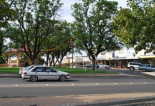
Loxton is a town on the south bank of the River Murray in the Riverland region of South Australia. At the 2016 census, Loxton had a population of 4,568. It is a service town for the surrounding districts. The area near Loxton is a significant citrus fruit and summer fruit growing area. Loxton is also the main town for the northern part of the Murray Mallee which is a dryland farming and grain cropping area.

Parilla is a town and a locality in the Australian state of South Australia located in the state's Murray Mallee region about 192 kilometres (119 mi) east of the state capital of Adelaide, about 32 kilometres (20 mi) west of the municipal seat of Pinnaroo and about 14 kilometres (8.7 mi) east of the town of Lameroo.
Jabuk is a locality in the Australian state of South Australia located about 142 kilometres (88 mi) south-east of the state capital of Adelaide and respectively about 78 kilometres (48 mi) west and 58 kilometres (36 mi) east of the municipal seats of Pinnaroo and Tailem Bend.
Mindarie is a small town in the Murray Mallee of South Australia between Karoonda and Loxton. The town was gazetted in 1912. The name Mindarie is believed to originate from the Dieri Aboriginal language, and possibly means "festival to invoke peace".
Marama is a town and a locality in the Australian state of South Australia located in the state's south-east about 146 kilometres (91 mi) east of the state capital of Adelaide and about 28 kilometres (17 mi) east of the municipal seat of Karoonda.
Wynarka is a very small town in South Australia 120 kilometres (75 mi) southeast of Adelaide on the Karoonda Highway (B55) and Loxton railway line in the Murray Mallee. Wynarka lies within the District Council of Karoonda East Murray.

Yumali is a very small country town in South Australia 162 km southeast of Adelaide on the Dukes Highway (A8). Yumali belongs to The Coorong District Council and is in the State electorate of Hammond and the Federal electorate of Barker. Yumali is in the County of Buccleuch.
Borrika is a town and locality in South Australia. It is on the Karoonda Highway 16 kilometres (9.9 mi) east of Karoonda, and was on the Barmera railway line, later known as the Loxton railway line when the end of the main line closed but the Loxton branch remained open until 2015 and has now also closed.
Galga is a settlement in the northern Murray Mallee region of South Australia. The town of Galga was surveyed in 1915 after the Waikerie railway line from Karoonda to Waikerie was opened in 1914. The line was shortened to Galga in 1990, and closed completely in 1994. There is a small bulk grain silo at Galga, but it is no longer regularly used. Galga has an active Country Fire Service brigade with one fire truck.
Halidon is a town and locality in the Australian state of South Australia located about 144 kilometres (89 mi) east of the state capital of Adelaide.
Perponda is a town and locality in the Australian state of South Australia located about 111 kilometres (69 mi) east of the state capital of Adelaide.
Sandalwood is a town and locality in the Australian state of South Australia located about 139 kilometres (86 mi) east of the state capital of Adelaide.
Wanbi is a town and locality in the Australian state of South Australia located about 157 kilometres (98 mi) east of the state capital of Adelaide and about 56 kilometres (35 mi) north-east of the municipal seat of Karoonda.
Bowhill is a locality in South Australia. A settlement is located inside a bend on the left (eastern/southern) bank of the Murray River between Mannum and Swan Reach. It is predominantly shacks built facing the river bank. The settlement is in the Mid Murray Council area, but most of the locality is located away from the river and within in the District Council of Karoonda East Murray, including the Lowan Conservation Park.
Mantung is a town and a locality in the Australian state of South Australia located in the state's south-east about 140 kilometres (87 mi) east of the state capital of Adelaide, and about 58 kilometres (36 mi) north-east and about 48 kilometres (30 mi) south-west respectively of the municipal seats of Karoonda and Loxton.

Burdett is a locality in South Australia located on the eastern side of the Murray River about 3.5 kilometres to the east of the city of Murray Bridge and about 74 kilometres east south-east of the Adelaide city centre. Its name is derived from the Hundred of Burdett.
Bakara is a rural locality in the District Council of Karoonda East Murray of the Murray and Mallee region of South Australia which was established on 11 November 1999.
Mercunda is a town and a locality in the Australian state of South Australia located in the state's south-east about 134 kilometres (83 mi) east of the state capital of Adelaide, and about 52 kilometres (32 mi) north-east and about 53 kilometres (33 mi) south-west respectively of the municipal seats of Karoonda and Loxton.
