
The Rhône is a major river in France and Switzerland, arising in the Alps and flowing west and south through Lake Geneva and southeastern France before discharging into the Mediterranean Sea. At Arles, near its mouth, the river divides into the Great Rhône and the Little Rhône. The resulting delta forms the Camargue region.

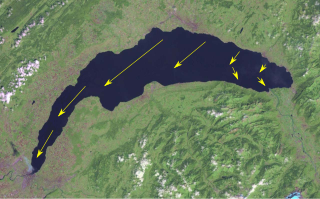
Lake Geneva is a deep lake on the north side of the Alps, shared between Switzerland and France. It is one of the largest lakes in Western Europe and the largest on the course of the Rhône. Sixty per cent of the lake belongs to Switzerland and forty per cent to France.

Valais, or Wallis, more formally the Canton of Valais, is one of the 26 cantons forming the Swiss Confederation. It is composed of thirteen districts and its capital and largest city is Sion. The flag of the canton is made of thirteen stars representing the districts, on a white-red background.

Les Portes du Soleil is a major skisports destination in the Alps, encompassing thirteen resorts between Mont Blanc in France and Lake Geneva in Switzerland. With more than 650 km of marked pistes and about 200 lifts in total, spread over 14 valleys and about 1,036 square kilometres (400 sq mi), Portes du Soleil ranks among the two largest ski areas in the world. Almost all of the pistes are connected by lifts – a few marginal towns can be reached only by the free bus services in the area. The highest altitude accessible on skis is 2260m and the lowest is 930m. As with many other Alpine ski resorts, the lower slopes of the Portes du Soleil have snow-making facilities to extend the ski season by keeping the lower slopes open during the warmer months.
The Bise is a cold, dry wind in Switzerland which blows through the Swiss Plateau from the northeast to the southwest.

Pas de Morgins is a high mountain pass in the Alps between the canton of Valais in Switzerland and France. It is located at the top of the Val de Morgins, which turns off the Val d'Illiez at Troistorrents.

The Rochers de Naye is a mountain of the Swiss Alps, overlooking Lake Geneva near Montreux and Villeneuve, in the canton of Vaud. They lie on the range separating the basin of Lake Geneva from the valley of the Sarine, on the watershed between the Rhone and the Rhine. The mountain is partially located in the canton of Fribourg, the border between the two cantons culminating on a lower summit named Grande Chaux de Naye.

The Dammastock is the highest mountain in the Urner Alps in Switzerland and is part of the Winterberg massif. Its summit ridge forms the border between the cantons of Uri and the Valais. It is the highest summit in the canton of Uri. The tripoint between the cantons of Berne, Valais and Uri lies near the Eggstock, north of the Dammastock. Politically, the Dammastcok is split between the municipalities of Göschenen (Uri) and Obergoms (Valais).

Lac de Morgins is a lake in Valais, Switzerland. It is located at Morgins, near the Pas de Morgins, the pass into France.

The Wildhorn is a mountain of the Alps, straddling the border between the Swiss cantons of Bern and Valais. At 3,248 metres (10,656 ft) above sea level, it is the highest summit of the Bernese Alps west of the Gemmi Pass. It forms a large glaciated massif, about 10 km wide, extending between the Sanetsch Pass and the Rawil Pass. Along with the Muverans, the Diablerets and the Wildstrubel, the Wildhorn is one of the four distinct mountain massifs of the Bernese Alps that lie west of the Gemmi Pass. The massif of the Wildhorn is at the centre between the valleys of the Saane, Simme and the Rhone (Valais). It comprises several distinct summits, including the Arpelistock, Le Sérac, the Geltenhorn, the Sex Noir, the Sex Rouge, the Schnidehorn and the Six des Eaux Froides. The main crest is between the glaciers named Tungelgletscher and Glacier du Wildhorn. South of the main summit is the almost equally high summit of Mont Pucel. The Wildhorn is surrounded by several large mountain lakes: the Lac de Sénin, the Lauenensee, the Iffigsee, the Lac de Tseuzier and the Lac des Audannes. The Tungelgletscher, on the north-east face, was measured as 1.9 km in length in 1973.

La Chapelle-d'Abondance is a commune in the Haute-Savoie department in the Auvergne-Rhône-Alpes region in south-eastern France.

The Dent de Morcles is a 2,969 metres high mountain located at western end of the Bernese Alps, overlooking the Rhone between Martigny and St. Maurice. It is the westernmost summit of the Muverans massif, which in turn is the westernmost of the four distinct mountain massifs of the Bernese Alps that lie west of the Gemmi Pass. Its position at the end of this chain of mountains and the abrupt drop to the wide valley of the Rhone river below make the Dent de Morcles prominently visible from many points in Lausanne and other populated areas on the north and northeastern shores of Lake Geneva.

Mont Fort is a mountain of the Pennine Alps, located near Verbier in the Swiss canton of Valais. It lies on the range between the valleys of Bagnes and Nendaz, north of the Rosablanche. With a height of 3,328 metres (10,919 ft) above sea level, Mont Fort is the highest summit north of the Col de Louvie.
The Grand Muveran is a mountain of the Bernese Alps, located on the border between the cantons of Vaud and Valais. At 3,051 metres, it is the highest summit of the group lying between the Rhone knee and the Pas de Cheville and the westernmost three-thousander of the Bernese Alps. The closest localities are Les Plans-sur-Bex and Ovronnaz (Valais). It is accompanied by the smaller peak of Petit Muveran.
The Haut de Cry is a mountain of the Bernese Alps, overlooking the Rhône Valley in the canton of Valais. It is composed of several summits, of which the highest has an elevation of 2,969 metres above sea level. The entire mountain lies within the basin of the Rhône, which flows approximately seven kilometres to the south.

Mont Tendre is a mountain of the Jura, located between the valley of Joux and the basin of Lake Geneva in the canton of Vaud. With an elevation of 1,679 metres above sea level, it is the highest summit of the Swiss portion of the Jura Mountains and, therefore, the highest summit of Switzerland outside the Alps. It is also the most isolated mountain of the canton. It is found in the community of Montricher.

Morgins is a village in the municipality of Troistorrents in the district of Monthey in the canton of Valais in southern Switzerland.

The Dent d'Oche is a mountain in the Haute-Savoie region of France, in the Chablais massif, near the Swiss-French border, that rises to 2,221 m (7,287 ft) in altitude. It towers above Évian, Thonon, and Lake Geneva. It offers a view of the French and Swiss Alps and the Swiss prealps.
The France–Switzerland border is 572 km (355 mi) long. Its current path is mostly the product of the Congress of Vienna of 1815, with the accession of Geneva, Neuchâtel and Valais to the Swiss Confederation, but it has since been modified in detail, the last time being in 2002. Although most of the border, marked with border stones, is unguarded, several checkpoints remain staffed, most notably on busy roads.
The Col de Cou is a high mountain pass of the Alps, located on the border between Switzerland and France. It connects Champéry in the Swiss canton of Valais to Morzine in the French department of Haute-Savoie. It is the lowest border crossing between the Pas de Morgins and the Dents du Midi.


