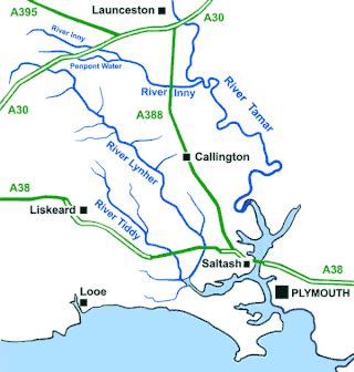
The River Lynher flows through east Cornwall, England, and enters the River Tamar at the Hamoaze, which in turn flows into Plymouth Sound.

Carn Marth is the name of a hill in Cornwall, England, United Kingdom, near Redruth. It is 235 m (771 ft) high, and is well known for the granite quarried from it in the past. The name of the hill comes from the Cornish language words karn (cairn) and margh, meaning 'horse'.
St Just, known as St Just in Penwith, is a town and civil parish in the Penwith district of Cornwall, England, United Kingdom. It lies along the B3306 road which connects St Ives to the A30 road. The parish encompasses the town of St Just and the nearby settlements of Trewellard, Pendeen and Kelynack: it is bounded by the parishes of Morvah to the north-east, Sancreed and Madron to the east, St Buryan and Sennen to the south and by the sea in the west. The parish consists of 7,622 acres (3,085 ha) of land, 12 acres (4.9 ha) of water and 117 acres (47.3 ha) of foreshore. The town of St Just is the most westerly town in mainland Britain and is situated approximately 8 miles (13 km) west of Penzance along the A3071. St Just parish, which includes Pendeen and the surrounding area, has a population of 4,637. An electoral ward of the same name also exists: the population of this ward at the same census was 4,812.

The Roseland Peninsula, or just Roseland, is a district of west Cornwall, England. Roseland is located in the south of the county and contains the town of St Mawes and villages such as St Just and Gerrans. It is a peninsula, separated from the remainder of Cornwall by the River Fal.

The Truro River is a river in the city of Truro in Cornwall, England, UK. It is the product of the convergence of the two rivers named Kenwyn and Allen which run under the city: the Truro River flows into the River Fal, estuarial waters where wildlife is abundant, and then out into the Carrick Roads. The river is navigable up to Truro.

The Helford River is a ria in Cornwall, England, fed by small streams into its many creeks. There are seven creeks on the Helford; from west to east these are Ponsontuel Creek, Mawgan Creek, Polpenwith Creek, Polwheveral Creek, Frenchman's Creek, Port Navas Creek, and Gillan Creek. The best known of these is Frenchman's Creek, made famous by Daphne du Maurier in her novel of the same name. A little further up river is Tremayne Quay, built for a visit by Queen Victoria in the 1840s which she then declined to make, allegedly because it was raining.

Porth Nanven is a beach in the far west of Cornwall, England, United Kingdom. It is located half-a-mile west of the town of St Just.

Carrick Roads is the estuary of the River Fal on the south coast of Cornwall in England. It joins the English Channel at its southern end near Falmouth.
Penberth is a valley, coastal village and cove on the Penwith peninsula in Cornwall, England. It is approximately 7 miles (11 km) southwest of Penzance. Most of the village is within the parish of St Buryan and the boundary with St Levan follows the Penberth river.

The Gover Stream is an approximately 3 kilometres (1.9 mi) long stream located in mid south Cornwall, England, United Kingdom.

Nanjizal, also known as Mill Bay, is a beach and cove in the civil parish of St Levan, Cornwall, on the south-western coast of Great Britain. Situated one mile to the south-east of Land's End, Nanjizal has no direct access via road, and is usually reached via the South West Coast Path from Land's End in the north, or from Porthgwarra to the south. Nanjizal is also a noted bird watching location.

The River Hayle is a small river in West Cornwall, England, United Kingdom which issues into St Ives Bay at Hayle on Cornwall's Atlantic coast.

The Par River, also known as the Luxulyan River is a river draining the area north of St Blazey in Cornwall, in the United Kingdom.
Cornwall is the county that forms the tip of the southwestern peninsula of England; this area has a mild and warm climate regulated by the Gulf Stream. The mild climate allows rich plant cover, such as palm trees in the far south and west of the county and in the Isles of Scilly, due to sub-tropical conditions in the summer.

The River Menalhyl is a river in Cornwall, England, that flows through the civil parishes of St Columb Major and Mawgan-in-Pydar. Its length is about 12 miles and it flows in a generally north-west direction. The name comes from the Cornish words melyn meaning mill and heyl meaning estuary - estuary mills. The name was recorded as Mellynheyl in the 19th century, but it had been known as Glyvion.

St Ives Bay is a bay on the Atlantic coast of north-west Cornwall, England, United Kingdom. It is in the form of a shallow crescent, some 4 miles or 6 km across, between St Ives in the west and Godrevy Head in the east.

The River Allen in north Cornwall is one of two rivers in Cornwall which share this name. In this case the name is the result of a mistake made in 1888 by Ordnance Survey, replacing the name Layne with Allen which is the old name for the lower reaches of the Camel. The other River Allen runs through Truro.

The River Ottery is a small river in northeast Cornwall, England, United Kingdom. The river is about twenty miles (32 km) long from its source southeast of Otterham to its confluence with the River Tamar at Nether Bridge, two miles (3.2 km) northeast of Launceston.

The St Austell River properly known as the River Vinnick, but historically called The White River, is a 12 kilometres (7.5 mi) long river located in south Cornwall, England, United Kingdom. 50.337°N 4.793°W. The river has also been known as the "red river" due to tin streaming and mining activity upstream.
