
Shropshire is a ceremonial county in the West Midlands of England, on the border with Wales. It is bordered by Cheshire to the north-east, Staffordshire to the east, Worcestershire to the south-east, Herefordshire to the south, and the Welsh principal areas of Powys and Wrexham to the west and north-west respectively. The largest settlement is Telford, while Shrewsbury is the county town.

The Severn Valley Railway is a standard gauge heritage railway in Shropshire and Worcestershire, England, named after the company that originally built the railway over which it now operates. The 16-mile (26 km) heritage line runs from Bridgnorth to Kidderminster, following the course of the River Severn along the Severn Valley for much of its route, and crossing the river on the historic Victoria Bridge.

The Shropshire Union Canal, sometimes nicknamed the "Shroppie", is a navigable canal in England. The Llangollen and Montgomery canals are the modern names of branches of the Shropshire Union (SU) system and lie partially in Wales.
Sundorne is a suburb of the town of Shrewsbury, county town of Shropshire. It is located 2 km north of the town centre. The B5062 road begins at Heathgates Roundabout and is called Sundorne Road in the Sundorne area, before crossing the Shrewsbury by-pass at Sundorne Roundabout and heading east towards Newport. Population : 5123, reducing to 3,957 at the 2011 census.

The English county of Shropshire has a fairly large railway network, with 19 National Rail stations on various national lines; there are also a small number of heritage and freight lines, including the famous heritage Severn Valley Railway running along its eastern border with Worcestershire.
The town of Shrewsbury in Shropshire, England, has a history that extends back at least as far as the year 901, but it could have been first settled earlier. During the early Middle Ages, the town was a centre of the wool trade, and this was a peak in its importance. During the Industrial Revolution, comparatively little development took place in the town, although it did serve as a significant railway town after the development of rail transport in the area. The town today retains much of its historic architecture.

Kidderminster railway station is the main station serving the large town of Kidderminster, Worcestershire, England and the wider Wyre Forest district. The station is operated by West Midlands Trains, and is on the Birmingham to Worcester via Kidderminster Line. Regular commuter services run to Birmingham and Worcester. It shares its station approach with the adjacent Severn Valley Railway station.

Ludlow railway station in Ludlow, Shropshire, England, lies on the Welsh Marches Line between Shrewsbury 27 miles 42 chains (44.3 km) to the north and Hereford. The station is on Station Drive, 1⁄2 mile (0.80 km) to the northeast of Ludlow town centre.

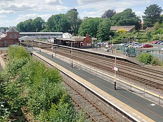
Shrewsbury railway station serves the town of Shrewsbury, in Shropshire, England. Built in 1848, it was designated a grade II listed building in 1969. Many services starting at or passing through the station are bound for Wales, and it is a key hub for its operator, Transport for Wales; services are also provided by West Midlands Railway.

Shelton is a suburb located in the west of the town of Shrewsbury in Shropshire, England, described by the Pevsner Architectural Guides as "Shrewsbury's principal interwar suburb."
Wellington railway station serves the town of Wellington, Shropshire, England. It is situated on the former Great Western Railway's London Paddington to Birkenhead via Birmingham Snow Hill line. Trains are operated by West Midlands Railway, and Transport for Wales.
The Bagley Brook is a small watercourse that flows into the River Severn at Shrewsbury in Shropshire, England.
Bagley is an area of Shrewsbury, county town of Shropshire. It is part urban, part rural and extends out from the town centre in a northwest direction. Though not clearly defined, it is often regarded as including Coton Hill, Greenfields and Gravelhill. The Shropshire Agricultural Showground is located between Coton Hill and Gravelhill.
The Shropshire County Show, formerly and to now often called the West Mid Show, is an annual agricultural show held on the outskirts of Shrewsbury, England, established in 1875.

Shrewsbury is a parliamentary constituency in England, centred on the town of Shrewsbury in Shropshire. It has been represented in the House of Commons of the Parliament of the United Kingdom since 2024 by Julia Buckley.
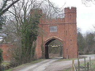
The Coton Hill rail crash was a train crash which occurred on 11 January 1965, at Coton Hill, near Shrewsbury in Shropshire, England.
Shrewsbury Town Council is the town council of Shrewsbury in Shropshire, established in April 2009 as part of structural changes to local government in England that abolished Shrewsbury and Atcham Borough Council and created in its place the unitary Shropshire Council. Shrewsbury was previously unparished, with the Mayor of Shrewsbury and Atcham acting as the town's mayor. With a population of over 76,000, Shrewsbury is the fourth-most populous parish in England.

Shrewsbury is a market town and civil parish in Shropshire, England. It is sited on the River Severn, 33 miles (53 km) northwest of Wolverhampton, 15 miles (24 km) west of Telford, 31 miles (50 km) southeast of Wrexham and 53 miles (85 km) north of Hereford. At the 2021 census, the parish had a population of 76,782. It is the county town of the ceremonial county of Shropshire.

The Coalport branch line was a standard gauge London and North Western Railway branch line in Shropshire, England, which ran between Hadley Junction near Oakengates on the Stafford to Shrewsbury line and a terminus at Coalport East railway station on the north bank of the River Severn at Coalport.
The town of Shrewsbury in Shropshire, England has historically been affected by flooding of the River Severn. The Frankwell area, has been particularly affected, but flood defence measures have largely been effective in the area.

