Billings Township is a civil township of Gladwin County in the U.S. state of Michigan. As of the 2010 census, the township population was 2,416.

The Pennines, also known as the Pennine Chain or Pennine Hills, are a range of uplands mainly located in Northern England. Commonly described as the "backbone of England" because of its length and position, the range runs from the north Midlands to North East England, near the Anglo-Scottish border. The Peak District is the southern end of the range, rising northwards from its foothills near the Trent Valley in northern Staffordshire, and further north into eastern Cheshire and southern Derbyshire. Beyond this are the South Pennines, Yorkshire Dales, and North Pennines, ending at the Tyne Gap. Beyond the gap are the Border Moors and Cheviot Hills, which are included in some definitions of the range.

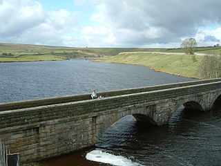
The Yorkshire Dales are an upland area of the Pennines in England. Most of the area is in the county of North Yorkshire, but it extends into Cumbria and a small part of Lancashire. It was historically entirely within Yorkshire. The majority of the Dales are part of the Yorkshire Dales National Park, created in 1954. The exception is the area around Nidderdale, which forms the separate Nidderdale Area of Outstanding Natural Beauty.

The Pennine Way is a National Trail in England, with a small section in Scotland. The trail stretches for 268 miles (431 km) from Edale, in the northern Derbyshire Peak District, north through the Yorkshire Dales and Northumberland National Park and ends at Kirk Yetholm, just inside the Scottish border. The path runs along the Pennine hills, sometimes described as the "backbone of England". Although not the United Kingdom's longest National Trail, it is according to The Ramblers, "one of Britain's best known and toughest".

The Dales Way is an 78.5-mile (126.3 km) long-distance footpath in Northern England, from Ilkley, West Yorkshire, to Bowness-on-Windermere, Cumbria. This walk was initially devised by the West Riding Ramblers' Association with the 'leading lights' being Colin Speakman and Tom Wilcock. The route was announced to the public in 1968 and the first recorded crossing was by a group of Bradford Grammar School Venture Scouts in 1969.
Littleborough is a village in the Metropolitan Borough of Rochdale, Greater Manchester, England, in the upper Roch Valley by the foothills of the South Pennines, 3 miles (4.8 km) northeast of Rochdale and 13 miles (20.9 km) northeast of Manchester; Milnrow and the M62 motorway are to the south, and the rural uplands of Blackstone Edge to the east. According to the 2001 census, Littleborough, and its suburbs of Calderbrook, Shore and Smithy Bridge, had a population of 13,807.

The North Pennines is the northernmost section of the Pennine range of hills which runs north–south through northern England. It lies between Carlisle to the west and Darlington to the east. It is bounded to the north by the Tyne Valley and to the south by the Stainmore Gap.

Cornriggs is a hamlet in County Durham, England. It is situated on the north side of Weardale in the North Pennines, which is designated as both an Area of Outstanding Natural Beauty and a UNESCO Global Geopark.

Hardraw Force is a waterfall on Hardraw Beck in Hardraw Scar, a wooded ravine just outside the hamlet of Hardraw, 0.9 miles (1.5 km) north of the town of Hawes, Wensleydale, in the Yorkshire Dales. The Pennine Way long distance footpath passes close by.

East Gill Force is a waterfall in Swaledale, 330 yards (300 m) east of the hamlet of Keld, in the Yorkshire Dales National Park, North Yorkshire, England. The falls are located on East Gill at grid reference NY896012, just before its confluence with the River Swale at the point where the Pennine Way and the Coast to Coast Walk intersect. The falls are a popular spot for visitors, not just long-distance walkers but also families and picnickers because of the proximity of the road. East Gill Force has two main torrents: the upper falls have an impressive 15-foot (4.5 m) drop whilst the lower section is a series of stepped cascades that fall 9.8 feet (3 m) as East Gill enters the River Swale.


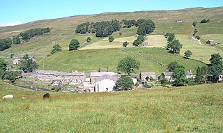
Cray is a hamlet on the B6160 road on a steep hill above Wharfedale in the Yorkshire Dales, North Yorkshire, England. It is near Buckden and the River Wharfe. It is a very popular walking area and is renowned for several waterfalls known collectively as Cray Waterfalls. The name of the settlement derives from the same name for the nearby beck ; Old Welsh Crei, meaning fresh. The settlement was not mentioned in the Domesday Book, first being recorded in 1202 when a meadow was granted as a fine to William de Arches at Creigate.
Oughtershaw is a hamlet in the Yorkshire Dales, North Yorkshire, England. It lies on a road it shares with other small villages; Deepdale, Yockenthwaite and Hubberholme, which traverses the watershed between Upper Wharfedale\Langstrothdale and Wensleydale over Fleet Moss into Gayle. The hamlet lies at 1,180 feet (360 m) above sea level. The name is first recorded in 1241 as Huctredsdale, and stems from Uhtred's copse, a personal name. It has had many spellings down the years, being known variously as Ughtershaw, Ughtirshey, Owghtershawe, and Outershaw in the 19th century.
The River Greta is a river in County Durham, England. It is a tributary of the River Tees and flows through the northern part of the old North Riding of Yorkshire. The name "Greta" derives from the Old Norse "Griótá", meaning "stony stream".

The Craven Fault System is the name applied by geologists to the group of crustal faults in the Pennines that form the southern edge of the Askrigg Block and which partly bounds the Craven Basin. Sections of the system's component faults which include the North, Middle and South Craven faults and the Feizor Fault are evident at the surface in the form of degraded faults scarps where Carboniferous Limestone abuts millstone grit. The fault system is approximately coincident with the southwestern edge of the Yorkshire Dales National Park and the northeastern edge of the Bowland Fells.
Ottumwa is an unincorporated hamlet in Haakon County, in the U.S. state of South Dakota. Only three homes and a farm are located there; no businesses or services.

Hainworth is a hamlet 1 mile (2 km) south of Keighley in West Yorkshire, England. The hamlet faces north across the lower end of the Worth Valley with a steep wooded incline towards Keighley.

Jacob's Ladder is a bridleway between Kinder Scout plateau and the hamlet of Upper Booth in the Vale of Edale, in the Derbyshire Peak District of England.