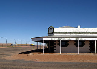
Birdsville is a rural town and locality in the Shire of Diamantina, Queensland, Australia. The locality is on the Queensland border with both the Northern Territory and South Australia. The town is situated 10 kilometres (6 mi) north of the South Australian border. In the 2021 census, the locality of Birdsville had a population of 110 people.

The Diamantina River is a major river in Central West Queensland and the far north of South Australia.

The Channel Country is a region of outback Australia mostly in the state of Queensland but also in parts of South Australia, Northern Territory and New South Wales. The name comes from the numerous intertwined rivulets that cross the region, which cover 150,000 km². The Channel Country is over the Cooper and Eromanga geological basins and the Lake Eyre Basin drainage basin. Further to the east is the less arid Maranoa district.

Innamincka Station, often called simply Innamincka, is a pastoral lease in the Australian state of South Australia. It operates as a cattle station. It is located about 4 kilometres north-east of the small township of the same name. 23 km (14 mi) west of the Queensland border, and 246 km (153 mi) south-east of Birdsville. As of 2012 the station – the second largest in South Australia after Anna Creek station – occupied an area of 13,552 square kilometres and was owned by the pastoral company, S. Kidman & Co.
Diamantina Lakes Station, most commonly known as Diamantina Lakes, was a pastoral lease that once operated as a cattle station in central west Queensland, and is now Diamantina National Park, a national park.

Glengyle Station is a pastoral lease that operates as a cattle station in central west Queensland.
Annandale Station, most commonly known as Annandale, is a pastoral lease that operates as a cattle station in central west Queensland. It is located on the tribal lands of the Wongkamala.
Alton Downs Station, most commonly known simply as Alton Downs, is a pastoral lease that operates as a cattle station in north east South Australia.

Mundowdna Station, most commonly known as Mundowdna, is a pastoral lease that operates as a cattle station in north east South Australia.
Pandie Pandie Station, most commonly known as Pandie Pandie, also often spelled as Pandi Pandi or Pandy Pandy, is a pastoral lease that operates as a cattle station in north east South Australia. It lies on the eastern edge of Karanguru territory.

Durrie Station is a pastoral lease that operates as a cattle station in Queensland, Australia.

Carandotta Station, most commonly referred to as Carandotta but often spelled as Carrandotta, is a pastoral lease that operates as a cattle station in Queensland, Australia. It is within the localities of Carrandotta and Piturie in the Shire of Boulia.
Morney Plains Station, most commonly referred to as Morney Plains, is a pastoral lease that operates as a cattle station in south west Queensland.
Mulka Station is a pastoral lease that operates as a cattle station in the far north of South Australia. The land occupying the extent of the Mulka Station pastoral lease was gazetted as a locality by the Government of South Australia on 26 April 2013 under the name "Mulka".

Clifton Hills Station is a pastoral lease that operates as a cattle station in the far north of South Australia.
Adria Downs Station is a pastoral lease that operates as a cattle station in the outback of Queensland.

Dulkaninna Station is a pastoral lease that once operated as a sheep station but now operates as a cattle station in outback South Australia.

Myrtle Springs Station is a pastoral lease that operates as a sheep station in outback South Australia.
Merty Merty is both a pastoral lease that once operated as a cattle station in north east South Australia and a locality. In April 2013, the land occupying the appropriate extent of the pastoral lease was gazetted by the Government of South Australia as a locality under the name Merty Merty.
Kidman's Tree of Knowledge is a heritage-listed tree at Glengyle Station, Bedourie, Shire of Diamantina, Queensland, Australia. It is also known as Tree of Knowledge. It was added to the Queensland Heritage Register on 21 October 1992.