Pandie Pandie Station

Last updated

Australia South Australia location map.svg
Red pog.svg
Pandie Pandie Station
Location in South Australia

Pandie Pandie Station, most commonly known as Pandie Pandie, also often spelled as Pandi Pandi or Pandy Pandy, is a pastoral lease that operates as a cattle station in north east South Australia. It lies on the eastern edge of Karanguru territory.

Contents

It is situated about 26 kilometres (16 mi) south of Birdsville and 222 kilometres (138 mi) north west of Innamincka along the banks of the Diamantina River in the channel country of South Australia. It is also situated toward the northern end of the Birdsville Track. [1]

History

The station was established in 1876 by Robert Frew [2] along with other properties in the area including Annandale, Alton Downs and Planet Downs. [3] Nearby Haddon Downs station was also taken up by Frew in 1877. [4]

Frew still owned the property in 1881 when he renamed the town of Diamantina Crossing to its present name of Birdsville after being amazed at the amount of birdlife found around the area. [3] [4]

By 1903 Sidney Kidman owned the property, and at this time it was completely destocked after suffering the effects of drought and the death of many cattle. [5]

In 1938, the station was acquired by the Morton family, who held it for 70 years until 2008. [6]

In 2008, the property was put up for auction for A$7–8 million as part of a package of three blocks – Pandie Pandie, Beckwith and Dickinna – with a total area of 6,625 square kilometres (2,558 sq mi). [7] It was sold for A$7.5 million to Viv Oldfield with 7800 head of cattle. [6]

Viv Oldfield, along with the Costello family, runs 50,000 cattle across seven stations with a total area of 40,000 square kilometres (15,444 sq mi) in the Northern Territory and South Australia. The manager of Pandie Pandie is Peter Morton (Pandie Pete). The station runs Brahman cattle. [8]

The land occupying the extent of the Pandie Pandie pastoral lease was gazetted as a locality in April 2013 under the name 'Pandie Pandie'. [9]

See also

Related Research Articles

<span class="mw-page-title-main">Bedourie, Queensland</span> Town in Queensland, Australia

Bedourie is a town and a locality in the Shire of Diamantina, Queensland, Australia. In the 2016 census, Bedourie had a population of 122 people.

<span class="mw-page-title-main">Birdsville</span> Town in Queensland, Australia

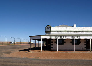
Birdsville is a rural town and locality in the Shire of Diamantina, Queensland, Australia. It is situated 10 kilometres (6 mi) north of the border of South Australia and Queensland. In the 2021 census, the locality of Birdsville had a population of 110 people. It is a popular tourist destination with many people using it as a starting point across the Simpson Desert.

<span class="mw-page-title-main">Diamantina River</span> River in South Australia, Australia

The Diamantina River is a major river in Central West Queensland and the far north of South Australia.

<span class="mw-page-title-main">Channel Country</span> Bioegion in Australia

The Channel Country is a region of outback Australia mostly in the state of Queensland but also in parts of South Australia, Northern Territory and New South Wales. The name comes from the numerous intertwined rivulets that cross the region, which cover 150,000 km². The Channel Country is over the Cooper and Eromanga geological basins and the Lake Eyre Basin drainage basin. Further to the east is the less arid Maranoa district.

<span class="mw-page-title-main">Shire of Diamantina</span> Local government area in Queensland, Australia

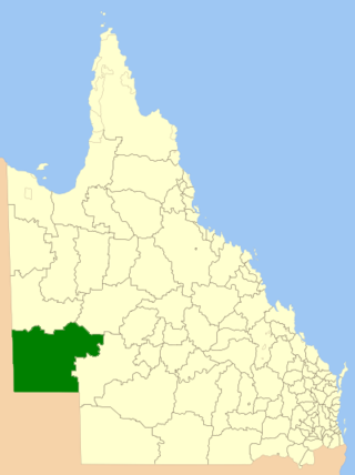
The Shire of Diamantina is a local government area in Central West Queensland, bordering South Australia and the Northern Territory. Its administrative centre is in the town of Bedourie.

<span class="mw-page-title-main">Davenport Downs Station</span> Pastoral lease in Queensland

<span class="mw-page-title-main">Coorabulka</span> Rural Australian cattle station

Coorabulka Station most commonly known as Coorabulka is a pastoral lease that operates as a cattle station in Queensland, Australia.

Marion Downs Station, often just referred to as Marion Downs, is a pastoral lease that operates as a cattle station in Queensland, Australia.

<span class="mw-page-title-main">Glengyle Station</span> Pastoral lease in central west Queensland

Glengyle Station is a pastoral lease that operates as a cattle station in central west Queensland.

Annandale Station, most commonly known as Annandale, is a pastoral lease that operates as a cattle station in central west Queensland. It is located on the tribal lands of the Wongkamala.

Cowarie Station most commonly known as Cowarie is a pastoral lease that operates as a cattle station in north east South Australia.

Alton Downs Station, most commonly known simply as Alton Downs, is a pastoral lease that operates as a cattle station in north east South Australia.

<span class="mw-page-title-main">Durrie Station</span> Pastoral lease and cattle station in Queensland

Durrie Station is a pastoral lease that operates as a cattle station in Queensland, Australia.

<span class="mw-page-title-main">Carandotta Station</span> Pastoral lease in Queensland, Australia

Carandotta Station, most commonly referred to as Carandotta but often spelled as Carrandotta, is a pastoral lease that operates as a cattle station in Queensland, Australia. It is within the localities of Carrandotta and Piturie in the Shire of Boulia.

Morney Plains Station, most commonly referred to as Morney Plains, is a pastoral lease that operates as a cattle station in south west Queensland.

<span class="mw-page-title-main">Clifton Hills Station</span> Pastoral lease in South Australia

<span class="mw-page-title-main">Royal Hotel, Birdsville</span> Historic site in Queensland, Australia

Royal Hotel is a heritage-listed former hotel, former hospital and now ruin at Adelaide Street, Birdsville, Shire of Diamantina, Queensland, Australia. It was built c. 1883. It was later known as Australian Inland Mission Hospital, AIM Hostel, and Birdsville Nursing Home. It was added to the Queensland Heritage Register on 21 October 1992.

<span class="mw-page-title-main">Birdsville Courthouse</span> Historic site in Queensland, Australia

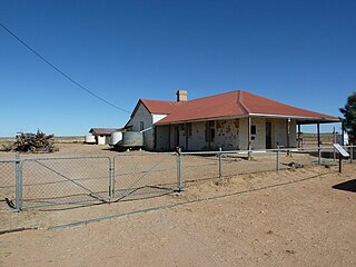
Birdsville Courthouse is a heritage-listed courthouse at Adelaide Street, Birdsville, Shire of Diamantina, Queensland, Australia. It was designed by the Queensland Department of Works and built from 1888 to 1890 by J Wookey and Henry Walton. It was added to the Queensland Heritage Register on 21 October 1992.

<span class="mw-page-title-main">Kidman's Tree of Knowledge</span> Historic site in Queensland, Australia

Kidman's Tree of Knowledge is a heritage-listed tree at Glengyle Station, Bedourie, Shire of Diamantina, Queensland, Australia. It is also known as Tree of Knowledge. It was added to the Queensland Heritage Register on 21 October 1992.

<span class="mw-page-title-main">Amaroo, Queensland</span> Suburb of Shire of Boulia, Queensland, Australia

Amaroo is an outback locality split between the Shire of Boulia and the Shire of Diamantina, both in Central Western Queensland, Australia. In the 2016 census, Amaroo had a population of 22 people.

References

  1. "The Birdsville Track". Flinders Range Research. 2012. Retrieved 9 June 2013.
  2. "Diamantine Shire History". Diamantina Shire. 2012. Archived from the original on 3 May 2013. Retrieved 9 June 2013.
  3. 1 2 "Birdsville". The Sydney Morning Herald . 8 February 2004. Retrieved 9 June 2013.
  4. 1 2 S. E. Pearson (1937). "The South West corner of Queensland" (PDF). University of Queensland. Retrieved 9 June 2013.
  5. "A pastoral trip". South Australian Register . Adelaide. 13 July 1903. p. 6. Retrieved 9 June 2013 via National Library of Australia.
  6. 1 2 "Pandie Pandie sells for $7.5m". Queensland Country Life . 13 October 2008. Archived from the original on 14 February 2015. Retrieved 9 June 2013.
  7. ""Pandie Pandie" Station via Birdsville Auction". Realestate.com.au. 2008. Retrieved 9 June 2013.
  8. "Viv Oldfield: A true cattleman". Weekly Times. 15 June 2011. Retrieved 9 June 2013.
  9. "Search result for " Pandie Pandie (LOCB)" (Record no SA0067165) with the following layers selected – "Suburbs and Localities" and " Place names (gazetteer)"". Property Location Browser. Government of South Australia. Archived from the original on 12 October 2016. Retrieved 22 May 2016.

26°08′S139°23′E / 26.13°S 139.39°E / -26.13; 139.39