The Australian Institute of Aboriginal and Torres Strait Islander Studies (AIATSIS), established as the Australian Institute of Aboriginal Studies (AIAS) in 1964, is an independent Australian Government statutory authority. It is a collecting, publishing and research institute and is considered to be Australia's premier resource for information about the cultures and societies of Aboriginal and Torres Strait Islander peoples. The Institute is a leader in ethical research and the handling of culturally sensitive material and holds in its collections many unique and irreplaceable items of cultural, historical and spiritual significance. The collection at AIATSIS has been built through over 50 years of research and engagement with Aboriginal and Torres Strait Islander communities and is now a source of language and culture revitalisation, native title research and family and community history. AIATSIS is located on Acton Peninsula in Canberra, Australian Capital Territory.
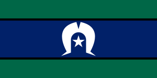
The Torres Strait Islander Flag is an official flag of Australia, and is the flag that represents Torres Strait Islander people. It was designed in 1992 by Bernard Namok. It won a local competition held by the Islands Coordinating Council, and was recognised by the Aboriginal and Torres Strait Islander Commission in June 1992.

The Adnyamathanha are a contemporary Indigenous Australian people from the Flinders Ranges, South Australia, formed as an aggregate of several distinct peoples. Strictly speaking the ethnonym Adnyamathanha was an alternative name for the Wailpi. Adnyamathanha is also often used as the name of their traditional language, although the language is more commonly called "yura ngarwala" by Adnyamathanha people themselves.

Doomadgee is a town and a locality in the Aboriginal Shire of Doomadgee, Queensland, Australia. In the 2016 census, Doomadgee had a population of 1405 people.
The Encyclopaedia of Aboriginal Australia: Aboriginal and Torres Strait Islander history, society and culture, edited by David Horton, is an encyclopaedia published by the Aboriginal Studies Press at the Australian Institute of Aboriginal and Torres Strait Islander Studies (AIATSIS) in 1994 and available in two volumes or on CD-ROM covering all aspects of Indigenous Australians lives and world. There are 2000 entries and 1000 photographs, with the CD-ROM having 250 sound items and 40 videos.
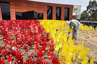
Indigenous Australians are people with familial heritage to groups that lived in Australia before British colonisation. They include the Aboriginal and Torres Strait Islander peoples of Australia. The term Aboriginal and Torres Strait Islander people, or the person's specific cultural group, is often preferred, though the terms First Nations of Australia, First Peoples of Australia and First Australians are also increasingly common.

Kanyaka Station was a cattle and sheep station in the Flinders Ranges of South Australia located at Kanyaka, approximately 40 km north-north-east of Quorn, South Australia. along Hawker-Stirling North Road (B83)
Natascha Duschene McNamara is an Ngarrindjeri Australian academic, activist, and researcher. She co-founded the Aboriginal Training and Cultural Institute in Balmain, New South Wales and served as President of the Aboriginal Children's Advancement Society Ltd. Her affiliations include: Fellowship, Centre of Indigenous Development Education and Research, University of Wollongong ; member, Australian Press Council; and Member, Australian Institute of Aboriginal and Torres Strait Islander Studies Council.

The Darling language, or Paakantyi (Baagandji), is a nearly extinct Australian Aboriginal language spoken along the Darling River in New South Wales from present-day Bourke to Wentworth and including much of the back country around the Paroo River and Broken Hill. The people's and language name refers to the Paaka with the suffix -ntyi meaning 'belonging to',
Madhi-Madhi, also known as Muthimuthi or Madi Madi, is an Indigenous Australian language spoken by the Muthi Muthi Aboriginal people of New South Wales.

Yarrah is a rural locality in the Far North region of South Australia. The eastern section of Yarrah lies within the Flinders Ranges Council, while the western section lies in the Pastoral Unincorporated Area.
Barndioota is a locality and former town in the southern Flinders Ranges west of Hawker. The bounded locality of Barndioota which corresponds to the cadastral Hundred of Barndioota, also includes the former town of Hookina and the site of the ceased Government Town of Barndioota which was surveyed in 1883 and declared ceased to exist in 1929.
Wilkatana Station is a sheep and cattle station in the Australian state of South Australia located north of the regional city of Port Augusta and south of Lake Torrens. It covers an area of 458 square kilometres (177 sq mi) which is located within the gazetted localities of Wilkatana Station in the west and Yarrah in the east.
Wallerberdina is a locality in the Australian state of South Australia located about 345 kilometres (214 mi) north of the state capital of Adelaide and about 40 kilometres (25 mi) west of the town of Hawker.
The Nangatadjara are an indigenous Australian people of Western Australia.
The Doolboong, also known as Duulngari, were an indigenous Australian people of the Northern Territory and northeast Western Australia.
Wallerberdina Station, most commonly known simply as Wallerberdina, is a pastoral lease that operates as a cattle station in South Australia.
Tangorin is a town and a locality in the Shire of Flinders, Queensland, Australia.
David Robert Horton is an Australian writer who has been described as a polymath, with qualifications and careers in science and the arts. He is known for his compilation of the work The Encyclopaedia of Aboriginal Australia: Aboriginal and Torres Strait Islander history, society and culture in 1994, and its accompanying map of Aboriginal groupings across Australia.
