Muloorina

Last updated

Australia South Australia location map.svg
Red pog.svg
Muloorina
Location in South Australia

Muloorina is both a pastoral lease that operates as a cattle station and a formal bounded locality in South Australia. The name and boundaries of the locality were created on 26 April 2013 after the long-established local name. [1]

The property is situated approximately 48 kilometres (30 mi) north of Marree and 156 kilometres (97 mi) east of William Creek. It is located on the edge of Lake Eyre, and Frome Creek runs through a portion of the station. [2]

The station currently occupies an area of 4,000 square kilometres (1,544 sq mi) and runs both sheep and cattle. [3]

The property was established some time prior to 1880 [4] on Tirari tribal land. By 1938 it was owned by Stan and Elliot Price and was under the management of Ellery Talbot. [5] The property was flooded in 1938 when Frome Creek broke its banks. [6]

In 1964, Donald Campbell and his 500 strong entourage stayed at the 800-square-kilometre (309 sq mi) property when he set the land speed record on the dry Lake Eyre in his car, Bluebird. [7]

The historic Lake Harry Date Plantation Site is located at Muloorina and listed on the South Australian Heritage Register. [8]

See also

Related Research Articles

<span class="mw-page-title-main">Lake Frome</span>

Lake Frome / Munda is a large endorheic lake in the Australian state of South Australia to the east of the Northern Flinders Ranges. It is a large, shallow, unvegetated salt pan, 100 kilometres (62 mi) long and 40 kilometres (25 mi) wide, lying mostly below sea level and having a total surface area of 259,615 hectares. It only rarely fills with brackish water flowing down usually dry creeks in the Northern Flinders Ranges from the west, or exceptional flows down the Strzelecki Creek from the north.

Lake Frome National Park, formerly Lake Frome Regional Reserve, is a protected area located in the Australian state of South Australia about 750 kilometres (470 mi) north-east of the state capital of Adelaide, in the Northern Flinders Ranges. It covers the full extent of Lake Frome, an endorheic and ephemeral salt lake. It has an area of 2,582.40 square kilometres (997.07 sq mi).

<span class="mw-page-title-main">Tirari Desert</span> Desert in South Australia

The Tirari Desert is a 15,250 square kilometres (5,888 sq mi) desert in the eastern part of the Far North region of South Australia. It stretches 212 km from north to south and 153 km from east to west.

Arcoona or Arcoona Station is a pastoral lease that operates as a sheep station.

<span class="mw-page-title-main">Cordillo Downs</span>

Cordillo Downs or Cordillo Downs Station is both a pastoral lease currently operating as a cattle station and a formal bounded locality in South Australia. It is located about 116 kilometres (72 mi) north of Innamincka and 155 kilometres (96 mi) south east of Birdsville. The name and boundaries of the locality were created on 26 April 2013 for the long established local name.

<span class="mw-page-title-main">Lake Nash Station</span> Cattle station in Northern Territory

<span class="mw-page-title-main">Glengyle Station</span> Pastoral lease in central west Queensland

Glengyle Station is a pastoral lease that operates as a cattle station in central west Queensland.

<span class="mw-page-title-main">Mundowdna Station</span> Pastoral lease in South Australia

Mundowdna Station, most commonly known as Mundowdna, is a pastoral lease that operates as a cattle station in north east South Australia.

Moolawatana Station mostly referred to as Moolawatana is a pastoral lease operating as a cattle station in South Australia.

<span class="mw-page-title-main">Clifton Hills Station</span> Pastoral lease in South Australia

Eringa Station is a pastoral lease that operates as a cattle station in the outback of South Australia, once owned by Sir Sidney Kidman. Its land is gazetted as a locality called Eringa in 2013.

<span class="mw-page-title-main">Todmorden Station (pastoral lease)</span> Pastoral lease in South Australia

<span class="mw-page-title-main">Dalhousie Station (South Australia)</span> Former pastoral lease in South Australia

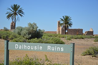
Dalhousie Station, most commonly known as Dalhousie Springs Station, was a pastoral lease that once operated as a cattle station in South Australia. Dalhousie and other surrounding leases were acquired by the Australian Government in 1985 to make up Witjira National Park.

<span class="mw-page-title-main">Arckaringa Station</span> Pastoral lease in South Australia

<span class="mw-page-title-main">Dulkaninna</span> Pastoral lease in South Australia

<span class="mw-page-title-main">Andamooka Station</span>

<span class="mw-page-title-main">Stuart Creek Station</span> Pastoral lease in South Australia

<span class="mw-page-title-main">Myrtle Springs Station</span> Pastoral lease in South Australia

References

  1. "Muloorina". Property Location Browser. Government of South Australia. Archived from the original on 12 October 2016. Retrieved 17 February 2016.
  2. "Muloorina Station". Outback Lakes SA. Archived from the original on 10 April 2013. Retrieved 9 September 2014.
  3. "Muloorina Station". Indigenous Studies Program, The University of Melbourne. 30 August 2012. Retrieved 11 September 2014.
  4. "Advertising". South Australian Register . Adelaide: National Library of Australia. 4 October 1880. p. 3. Retrieved 12 September 2014.
  5. "Reports from rural Centres". The Advertiser . Adelaide: National Library of Australia. 3 June 1938. p. 27. Retrieved 12 September 2014.
  6. "Queensland Fatality: Flooded North: Docks Busy:". The Chronicle . Adelaide: National Library of Australia. 23 February 1939. p. 36. Retrieved 12 September 2014.
  7. Alison Painter. "17 July 1964 Donald Campbell, Bluebird and Muloorina Station". Professional Historians Association (SA). Retrieved 9 September 2014.
  8. "Lake Harry Date Plantation Site". South Australian Heritage Register. Department of Environment, Water and Natural Resources. Archived from the original on 5 March 2016. Retrieved 12 February 2016.

29°14′22″S137°54′20″E / 29.23943°S 137.90548°E / -29.23943; 137.90548