Commonwealth Hill Station

Last updated

Australia South Australia location map.svg
Red pog.svg
Commonwealth Hill  Station
Location in South Australia

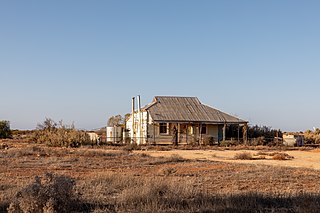
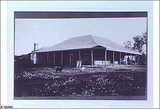
Commonwealth Hill Station more commonly known as Commonwealth Hill is a pastoral lease currently operating as a sheep station.

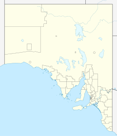
Commonwealth Hill is located about 96 kilometres (60 mi) north north west of Tarcoola and 120 kilometres (75 mi) south west of Coober Pedy in the state of South Australia.

The property occupies an area of approximately 10,000 square kilometres (3,861 sq mi) or one million hectares, [1] making it the second largest sheep station in Australia, after Rawlinna Station. It is currently owned by the Jumbuck Pastoral Company.

The land on which the station is situated is described as a flat sandy plain on the north western margin of the Gawler Craton covered with sand sheets and dunefields. Low mulga woodlands and tall myall shrublands over perennial grasses dominate with occasional salt lakes and lunette systems. [2]

In 1947 the station was enjoying an excellent season after good rains produced an abundance of fresh green feed for stock during the summer. The area was also rife with rumours that the Woomera Test Range was to be expanded and that stations including Commonwealth Hill, Bulgunnia, Roxby Downs and Andamooka would lose some of land which in turn would reduce their wool clip. [3] The rumours were true and the station lies within the Woomera Test Range Area. [4] Byron MacLachlan, the leaseholder of Commonwealth Hill in 1947, along with a consortium of pastoralists and lawyers established a working agreement to ensure the continuation of pastoral activity that would not interfere with the long range weapons project.

In 1956 before the trials of the Black Knight Rocket commenced at Woomera safety risks to pastoralists were identified as a key concern. In 1957 the minister of Supply, Howard Beale spoke with the graziers who could be affected by the trials and announced that the Commonwealth government would pay for the installation of blast-proof shelters. [5]

An iron ore exploration company, Apollo Minerals, was given permission in 2011 by the Defence Department to start work on its prospect in the area following a Federal Government review on mining in the former missile testing area. [4]

In 2013, the land occupied by the pastoral lease was declared by the Government of South Australia under the Geographical Names Act 1991 as a locality with the name “Commonwealth Hill.” [6] [7]

See also

Related Research Articles

<span class="mw-page-title-main">Station (Australian agriculture)</span> Large landholding used for livestock production

In Australia, a station is a large landholding used for producing livestock, predominantly cattle or sheep, that needs an extensive range of grazing land. The owner of a station is called a pastoralist or a grazier, corresponding to the North American term "rancher".

<span class="mw-page-title-main">Woomera, South Australia</span> Town in South Australia

Woomera, unofficially Woomera village, refers to the domestic area of RAAF Base Woomera. Woomera village has always been a Defence-owned and operated facility. The village is located on the traditional lands of the Kokatha people in the Far North region of South Australia, but is on Commonwealth-owned land and within the area designated as the 'Woomera Prohibited Area' (WPA). The village is approximately 446 kilometres (277 mi) north of Adelaide. In common usage, "Woomera" refers to the wider RAAF Woomera Range Complex (WRC), a large Australian Defence Force aerospace and systems testing range covering an area of approximately 122,000 square kilometres (47,000 sq mi) and is operated by the Royal Australian Air Force.

<span class="mw-page-title-main">Rawlinna, Western Australia</span> Town in Western Australia

Rawlinna is an isolated locality on the Trans-Australian Railway in Western Australia, about 900 kilometres east of Perth and 350 kilometres west of the Western Australia / South Australia border. It is on the Nullarbor Plain, about 50 kilometres from its western fringe; the topography is flat and well grassed, with saltbush and bluebush, with small belts of myall and myoporum trees. Annual rainfall is 288 millimetres. Maximum daytime temperatures are typically 38 °C (100 °F) through summer and 19 °C (66 °F) during winter. In 2016, the population in the area was recorded as 30 people.

<span class="mw-page-title-main">Bulgunnia Station</span>

Bulgunnia Station is a 3,200 square kilometres (1,236 sq mi) sheep station in north-western South Australia.

Arcoona or Arcoona Station is a pastoral lease that operates as a sheep station.

Mount Victor Station is a pastoral lease currently operating as a sheep station located about 115 kilometres (71 mi) east of Hawker and 175 kilometres (109 mi) west of Broken Hill in the state of South Australia,

<span class="mw-page-title-main">Rawlinna Station</span> Pastoral lease in Western Australia

Rawlinna Station is a pastoral lease and sheep station located about 339 kilometres (211 mi) east of Kambalda in the Goldfields-Esperance region of Western Australia. The locality of Rawlinna and the Trans-Australian Railway are situated along the boundary of the station. It is the largest sheep station in Australia.

<span class="mw-page-title-main">Madura Station</span> Pastoral lease in Western Australia

Madura Station also known as Madura Plains is a pastoral lease and sheep station located about 700 kilometres (435 mi) east south east of Kalgoorlie in the Goldfields-Esperance region of Western Australia. It is within the locality of Madura and the Eyre Highway runs along the boundary of the station.

Wilgena Station, commonly known as simply Wilgena, is a pastoral lease that operates as a sheep station in outback South Australia.

Canowie or Canowie Station was a former pastoral lease located about 18 kilometres (11 mi) north west of Hallett and 23 kilometres (14 mi) south west of Terowie in the state of South Australia.

<span class="mw-page-title-main">RAAF Woomera Range Complex</span> Aerospace facility in South Australia

The RAAF Woomera Range Complex (WRC) is a major Australian military and civil aerospace facility and operation located in South Australia, approximately 450 km (280 mi) north-west of Adelaide. The WRC is operated by the Royal Australian Air Force (RAAF), a division of the Australian Defence Force (ADF). The complex has a land area of 122,188 km2 (47,177 sq mi) or roughly the size of North Korea or Pennsylvania. The airspace above the area is restricted and controlled by the RAAF for safety and security. The WRC is a highly specialised ADF test and evaluation capability operated by the RAAF for the purposes of testing defence materiel.

Moolawatana Station mostly referred to as Moolawatana is a pastoral lease operating as a cattle station in South Australia.

Jumbuck Pastoral Company is an Australian company that operates numerous cattle stations and sheep stations in Western Australia, South Australia and the Northern Territory

<span class="mw-page-title-main">Murnpeowie</span> Pastoral lease in South Australia

<span class="mw-page-title-main">Mount Eba Station</span> Pastoral lease in South Australia

Billa Kalina Station is a pastoral lease that once operated as a sheep station but now operates as a cattle station in outback South Australia.

References

  1. "Commonwealth Hill". Jumbuck Pastoral Company. 2012. Archived from the original on 9 April 2013. Retrieved 28 January 2013.
  2. "South Australian Arid Lands Biodiversity Strategy" (PDF). Jumbuck Pastoral Company. 2009. Archived from the original on 13 November 2012. Retrieved 28 January 2013.{{cite web}}: CS1 maint: bot: original URL status unknown (link)
  3. "Rocket site anxiety". The Advertiser . Adelaide, South Australia: National Library of Australia. 4 December 1947. p. 3. Retrieved 30 January 2013.
  4. 1 2 "Apollo gets permit for Woomera exploration". Australian Broadcasting Corporation. 26 October 2011. Retrieved 28 January 2013.
  5. "Pastoral History". National Library of Australia. 2012. Archived from the original on 21 December 2009. Retrieved 30 January 2013.
  6. Proposed Locality Boundaries for Pastoral Areas (PDF) (Map). Department for Planning, Transport and Infrastructure, Government of South Australia. 31 October 2012. Rack Plan 951. Archived from the original (PDF) on 23 September 2015. Retrieved 5 September 2015.
  7. "Search result for "Commonweath Hill (LOCB)" (Record no SA0067039)". Department of Planning Transport and Infrastructure. Archived from the original on 12 October 2016. Retrieved 12 September 2015.

29°56′35″S134°9′8″E / 29.94306°S 134.15222°E / -29.94306; 134.15222