
A mangrove is a shrub or small tree that grows in coastal saline or brackish water. The term is also used for tropical coastal vegetation consisting of such species. Mangroves occur worldwide in the tropics and subtropics, mainly between latitudes 25° N and 25° S. The total mangrove forest area of the world in 2000 was 137,800 square kilometres (53,200 sq mi), spanning 118 countries and territories.

An estuary is a partially enclosed coastal body of brackish water with one or more rivers or streams flowing into it, and with a free connection to the open sea.

A lagoon is a shallow body of water separated from a larger body of water by barrier islands or reefs. Lagoons are commonly divided into coastal lagoons and atoll lagoons. They have also been identified as occurring on mixed-sand and gravel coastlines. There is an overlap between bodies of water classified as coastal lagoons and bodies of water classified as estuaries. Lagoons are common coastal features around many parts of the world.

The Wash is a rectangular bay and estuary at the north-west corner of East Anglia on the East coast of England, where Norfolk meets Lincolnshire, and both border the North Sea. One of the broadest estuaries in the United Kingdom, it is fed by the rivers Witham, Welland, Nene and Great Ouse. It is a 62,046-hectare (153,320-acre) biological Site of Special Scientific Interest. It is also a Nature Conservation Review site, Grade I, a National Nature Reserve, a Ramsar site, a Special Area of Conservation and a Special Protection Area. It is in the Norfolk Coast Area of Outstanding Natural Beauty and part of it is the Snettisham Royal Society for the Protection of Birds nature reserve.

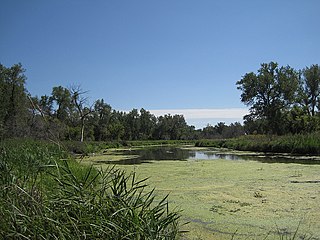
A wetland is a distinct ecosystem that is flooded by water, either permanently or seasonally, where oxygen-free processes prevail. The primary factor that distinguishes wetlands from other land forms or water bodies is the characteristic vegetation of aquatic plants, adapted to the unique hydric soil. Wetlands play a number of functions, including water purification, water storage, processing of carbon and other nutrients, stabilization of shorelines, and support of plants and animals. Wetlands are also considered the most biologically diverse of all ecosystems, serving as home to a wide range of plant and animal life. Whether any individual wetland performs these functions, and the degree to which it performs them, depends on characteristics of that wetland and the lands and waters near it. Methods for rapidly assessing these functions, wetland ecological health, and general wetland condition have been developed in many regions and have contributed to wetland conservation partly by raising public awareness of the functions and the ecosystem services some wetlands provide.
A river delta is a landform created by deposition of sediment that is carried by a river as the flow leaves its mouth and enters slower-moving or stagnant water. This occurs where a river enters an ocean, sea, estuary, lake, reservoir, or another river that cannot carry away the supplied sediment. The size and shape of a delta is controlled by the balance between watershed processes that supply sediment, and receiving basin processes that redistribute, sequester, and export that sediment. The size, geometry, and location of the receiving basin also plays an important role in delta evolution. River deltas are important in human civilization, as they are major agricultural production centers and population centers. They can provide coastline defense and can impact drinking water supply. They are also ecologically important, with different species' assemblages depending on their landscape position.

A marsh is a wetland that is dominated by herbaceous rather than woody plant species. Marshes can often be found at the edges of lakes and streams, where they form a transition between the aquatic and terrestrial ecosystems. They are often dominated by grasses, rushes or reeds. If woody plants are present they tend to be low-growing shrubs, and then sometimes called carrs. This form of vegetation is what differentiates marshes from other types of wetland such as swamps, which are dominated by trees, and mires, which are wetlands that have accumulated deposits of acidic peat.

A salt marsh or saltmarsh, also known as a coastal salt marsh or a tidal marsh, is a coastal ecosystem in the upper coastal intertidal zone between land and open saltwater or brackish water that is regularly flooded by the tides. It is dominated by dense stands of salt-tolerant plants such as herbs, grasses, or low shrubs. These plants are terrestrial in origin and are essential to the stability of the salt marsh in trapping and binding sediments. Salt marshes play a large role in the aquatic food web and the delivery of nutrients to coastal waters. They also support terrestrial animals and provide coastal protection.

Mudflats or mud flats, also known as tidal flats, are coastal wetlands that form in intertidal areas where sediments have been deposited by tides or rivers. A recent global analysis suggested they are as extensive globally as mangroves. They are found in sheltered areas such as bays, bayous, lagoons, and estuaries. Mudflats may be viewed geologically as exposed layers of bay mud, resulting from deposition of estuarine silts, clays and marine animal detritus. Most of the sediment within a mudflat is within the intertidal zone, and thus the flat is submerged and exposed approximately twice daily.

A body of water or waterbody is any significant accumulation of water, generally on a planet's surface. The term most often refers to oceans, seas, and lakes, but it includes smaller pools of water such as ponds, wetlands, or more rarely, puddles. A body of water does not have to be still or contained; rivers, streams, canals, and other geographical features where water moves from one place to another are also considered bodies of water.
A Ramsar site is a wetland site designated to be of international importance under the Ramsar Convention.

A tidal marsh is a marsh found along rivers, coasts and estuaries which floods and drains by the tidal movement of the adjacent estuary, sea or ocean. Tidal marshes experience many overlapping persistent cycles, including diurnal and semi-diurnal tides, day-night temperature fluctuations, spring-neap tides, seasonal vegetation growth and decay, upland runoff, decadal climate variations, and centennial to millennial trends in sea level and climate. They are also impacted by transient disturbances such as hurricanes, floods, storms, and upland fires.
An aquatic ecosystem is an ecosystem in a body of water. Communities of organisms that are dependent on each other and on their environment live in aquatic ecosystems. The two main types of aquatic ecosystems are marine ecosystems and freshwater ecosystems.

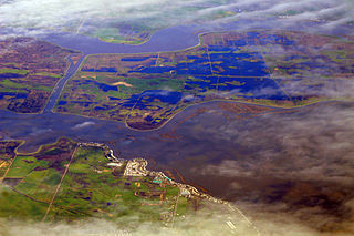
The wetlands of Louisiana are water-saturated coastal and swamp regions of southern Louisiana.
A mangrove swamp is a distinct saline woodland or shrubland habitat formed by mangrove trees in brackish tidal water. They are characterized by depositional coastal environments, where fine sediments collect in areas protected from high-energy wave action. The saline conditions tolerated by various mangrove species range from brackish water, through pure seawater, to water concentrated by evaporation to over twice the salinity of ocean seawater.

Located in northern California the Suisun Marsh is the largest brackish water marsh on west coast of the United States of America. The marsh land is part of the San Francisco Bay tidal estuary, and subject to tidal ebb and flood. The marsh is home to many species of birds and other wildlife, and is formed by the confluence of the Sacramento and San Joaquin rivers between Martinez and Suisun City, California and several other smaller, local watersheds. Adjacent to Suisun Bay, the marsh is immediately west of the legally defined Sacramento-San Joaquin Delta as well as part of the San Francisco Bay estuary.

In ecology, a halosere is a succession in a saline environment. An example of a halosere is a salt marsh.
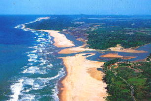
Ennore creek is a backwater located in Ennore, Chennai along the Coromandel Coast of the Bay of Bengal. It is located in the zone comprising lagoons with salt marshes and backwaters, submerged under water during high tide and forming an arm of the sea with the opening to the Bay of Bengal at the creek. The zone is spread over an area of 4 km2, and the creek covers an area of 2.25 km2. It is located 20 km north of the city centre and 2.6 km south of the Ennore Port, and the creek area stretches 3 km into the sea and 5 km along the coast. The creek is nearly 400 m wide, elongated in northeast–southwest direction and merging with the backwater bodies. Once a flourishing mangrove swamp, the creek has been degraded to patches in the fringes mainly due to human activities in the region. The depth of the creek varies from 1 to 2 m and is shallow near the mouth. The north–south trending channels of the creek connect it with the Pulicat Lake to the north and to the distributaries of the Kosasthalaiyar River in the south. The northwestern part of the creek merges with the tidal flats. The soil in the region is of loamy and alluvial types. Most of the area consists of tracts of alluvial soil and the eastern region comprises beach dunes, tidal flats and creek. The creek is oriented from west to east and opens into the Bay of Bengal to the east at Ennore. The creek acts as an outlet for the excess water from the Poondi Reservoir. The creek separates the town of Ennore from the Ennore Port located in the north and the Kattupalli Shipyard located further north. The North Chennai Thermal Power Station is located at the north of the creek and the Ennore Thermal Power Station is located to the south. The creek is part of the Pulicat water system, including the Pulicat lagoon and the Buckingham Canal. As per the 1991 Coastal Regulation Zone notification, the entire Pulicat water system is designated CRZ I. The creek is experiencing siltation due to emergence of the Ennore Port.
A slough is a wetland, usually a swamp or shallow lake, often a backwater to a larger body of water. Water tends to be stagnant or may flow slowly on a seasonal basis.
Coastal Erosion in Louisiana is the process of steady depletion of wetlands along the state's coastline in marshes, swamps, and barrier islands, particularly affecting the alluvial basin surrounding the mouth of the Mississippi River at the foot of the Gulf of Mexico on the Eastern half of the state's coast. In the last century, Southeast Louisiana has lost a large portion of its wetlands and is expected to lose more in the coming years, with some estimates claiming wetland losses equivalent to up to 1 football field per hour. One consequence of coastal erosion is an increased vulnerability to hurricane storm surges, which affects the New Orleans metropolitan area and other communities in the region. The state has outlined a comprehensive master plan for coastal restoration and has begun to implement various restoration projects such as fresh water diversions, but certain zones will have to be prioritized and targeted for restoration efforts, as it is unlikely that all depleted wetlands can be rehabilitated.

