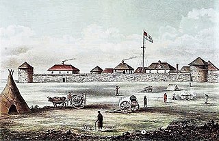
Fort Garry, also known as Upper Fort Garry, was a Hudson's Bay Company trading post at the confluence of the Red and Assiniboine rivers in what is now downtown Winnipeg.

Winnipeg South Centre is a federal electoral district in Manitoba, Canada, that has been represented in the House of Commons of Canada from 1925 to 1979 and since 1988.

Charleswood is a residential community and neighbourhood in Winnipeg, Manitoba, Canada. It is located in the South-West of the city and is bordered by the neighbourhoods Tuxedo to the East, Fort Whyte to the South, and the Rural Municipality of Headingley on the West. It's boundaries are Roblin and the Assiniboine River to the north, Shaftesbury Boulevard on the East, Wilkes Avenue to the South and the Perimeter Highway to the West.

Tuxedo is a residential suburb of Winnipeg, Manitoba. It is located about 7 kilometres southwest of downtown Winnipeg and borders the Assiniboine River and Assiniboine Park on the north, Shaftesbury Boulevard on the west, Route 90 to the East and McGillvary Boulevard to the South. Prior to 1972, the community was incorporated as the Town of Tuxedo.
Wolseley is a neighbourhood located within the West End of Winnipeg, Manitoba. It is named for field marshal Sir Garnet Wolseley, a British Army officer who came to Manitoba in 1870 to suppress the Red River Rebellion.
Academy Road is a street in Winnipeg, Manitoba, Canada. It runs from the Maryland Bridge to Wellington Crescent, just west of Route 90, and actually intersects with Wellington at both its east and west ends. Academy Road is located in the residential neighbourhood of River Heights and has many retail stores along it.
River Heights is a suburb and community area in Winnipeg, Manitoba. It is bordered by Route 90 to the west, the Assiniboine River to the north, Cambridge Street to the east, and Taylor Avenue to the south.

Fort Rouge is a district of Winnipeg, Manitoba, in Canada. Located in the south-central part of the city, it is bounded on the north by the Assiniboine River, on the east and south by the Red River, and on the west by Stafford Street and Pembina Highway.
Fort Garry is a community area and neighbourhood of Winnipeg, Manitoba, Canada, located in the southwestern part of the city, south of the district of Fort Rouge and east of the Tuxedo area. It comprises parts of the city wards of River Heights - Fort Garry, Fort Rouge - East Fort Garry, Waverley West, and St. Norbert - Seine River.

Osborne Village is a neighbourhood of Winnipeg, Manitoba. The area is bordered by the Assiniboine River on the north and west, Harkness Station on the east, and the Osborne Underpass on the south.

St. James-Assiniboia is a major community area in Winnipeg, Manitoba, Canada. As it encapsulates most of the city ward of St. James, which includes the major St. James Street, the area itself is often simply referred to "St. James."

Downtown Winnipeg is an area of Winnipeg located near the confluence of the Red and Assiniboine rivers. It is the oldest urban area in Winnipeg, and is home to the city's commercial core, city hall, the seat of Manitoba's provincial government, and a number of major attractions and institutions.

Route 105 is a major east-west arterial route in the city of Winnipeg. It runs through the suburbs of Fort Rouge, River Heights, Tuxedo, and Charleswood. It is the eastern extension of Provincial Road 241, which runs westward to the communities of Headingley and Lido Plage. Within the city boundaries it connects the residential and light industrial areas west-southwest of downtown with the Pembina Highway and downtown.

The history of Winnipeg comprises its initial population of Aboriginal peoples through its settlement by Europeans to the present day. The first forts were built on the future site of Winnipeg in the 1700s, followed by the Selkirk Settlement in 1812. Winnipeg was incorporated as a city in 1873 and experienced dramatic growth in the late 19th and early 20th centuries. Following the end of World War I, the city's importance as a commercial centre in Western Canada began to wane. Winnipeg and its suburbs experienced significant population growth after 1945, and the current City of Winnipeg was created by the unicity amalgamation in 1972.

Armstrong's Point is a neighbourhood in Winnipeg, Manitoba. It is located in the West End of the city and in a large bend in the Assiniboine River. The land was developed in the late 19th and early 20th centuries as a residential district.
Rockwood is a neighbourhood in the River Heights area of south-central Winnipeg, Manitoba.

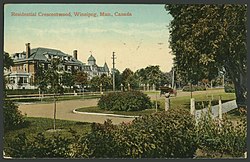
Wellington Crescent is an affluent neighbourhood in Winnipeg, Manitoba, Canada. It is known for its stately homes and for a small commercial area along Academy Road.
Broadway is a street in the city of Winnipeg, Manitoba, Canada. It is one of the city's oldest and most historic routes and forms the Trans-Canada Highway route through the city's downtown.
Old Tuxedo is an affluent residential suburban neighbourhood in Tuxedo, Winnipeg. It is bounded by the Assiniboine River to the North, Park Boulevard N to the west, Tuxedo Avenue and Roblin Boulevard to the south and Route 90 to the east.