Winnipeg is the capital and largest city of the province of Manitoba in Canada. It is centred on the confluence of the Red and Assiniboine rivers, near the longitudinal centre of North America. As of 2021, Winnipeg had a city population of 749,607 and a metropolitan population of 834,678, making it Canada's sixth-largest city and eighth-largest metropolitan area.

Brandon is the second-largest city in the province of Manitoba, Canada. It is located in the southwestern corner of the province on the banks of the Assiniboine River, approximately 214 km (133 mi) west of the provincial capital, Winnipeg, and 120 km (75 mi) east of the Saskatchewan border. Brandon covers an area of 77.41 km2 (29.89 sq mi) with a population of 51,313, and a census metropolitan area population of 54,268. It is the primary hub of trade and commerce for the Westman Region as well as parts of southeastern Saskatchewan and northern North Dakota, an area with a population of over 190,000 people.

Charleswood is a semi-rural residential community and neighbourhood in Winnipeg, Manitoba, Canada. It is located in the South-West of the city and is bordered by the neighbourhoods Tuxedo to the East, Fort Whyte to the South, and the Rural Municipality of Headingley on the West. It's boundaries are Roblin and the Assiniboine River to the north, Shaftesbury Boulevard on the East, Wilkes Avenue to the South and the Perimeter Highway to the West.
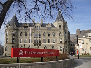
River Heights is a provincial electoral division in the Canadian province of Manitoba. It was created by redistribution in 1957, and formally came into existence in the 1958 provincial election. The riding is located in the south-central region of the City of Winnipeg.

Winkler is a city in Manitoba, Canada with a population of 13,745, making it the 4th largest city in Manitoba, as of the 2021 Canadian census. It is located in southern Manitoba, surrounded by the Rural Municipality of Stanley, about one hundred kilometres southwest of Winnipeg and thirteen kilometres east of its "twin city" Morden. As the largest city in the Pembina Valley, it serves as a regional hub for commerce, agriculture and industry. Winkler is the third-fastest growing city in the province after Morden and Steinbach.

Morden is a city located in the Pembina Valley region of southern Manitoba, Canada near the United States border. It is about 11 km (6.8 mi) west of the neighbouring city of Winkler; together Morden and Winkler are often referred to as Manitoba's Twin Cities. Morden, which is surrounded by the Rural Municipality of Stanley, is the eighth largest and fastest-growing city in Manitoba. According to Statistics Canada, the city had a population of 9,929 in 2021, an increase of 14.5% from 2016, making it Manitoba's fastest growing city.
Emerson is an unincorporated community recognized as a local urban district in south central Manitoba, Canada, located within the Municipality of Emerson – Franklin. It has a population of 678 as of the 2016 Canada census.

Carman is a small agricultural town of about 3,000 people in the Pembina Valley Region of southern Manitoba, Canada. Carman is at the junction of Highways 3 and 13, 40 minutes southwest of Winnipeg. It is surrounded by the Rural Municipality of Dufferin, in the heart of a rich prairie agricultural belt, 60 km (37 mi) north of the American state of North Dakota. The Boyne River does pass through Carman.

Morris is a small town in the Pembina Valley region of Manitoba, Canada, located 51 km south of Winnipeg and 42 km north of Emerson. Morris is home to 1,885 people (2016). Named after Alexander Morris, the second Lieutenant Governor of Manitoba.

Fort Rouge is a district of Winnipeg, Manitoba, in Canada. Located in the south-central part of the city, it is bounded on the north by the Assiniboine River, on the east and south by the Red River, and on the west by Stafford Street and Pembina Highway.
Fort Garry is a community area and neighbourhood of Winnipeg, Manitoba, Canada, located in the southwestern part of the city, south of the district of Fort Rouge and east of the Tuxedo area. It comprises parts of the city wards of River Heights - Fort Garry, Fort Rouge - East Fort Garry, Waverley West, and St. Norbert - Seine River.

St. Adolphe, or Saint Adolphe, originally called Pointe-Coupée, is a community in the Rural Municipality of Ritchot, Manitoba, Canada. It is located along the east bank of the Red River, approximately 12 kilometres south of Winnipeg.
Pembina Trails School Division is a school division serving the southwest communities of Winnipeg, Manitoba, with 36 schools.
Waverley West is a city ward and suburb in southwest Winnipeg, Manitoba.
Grant Park is a neighbourhood in the River Heights area of southern Winnipeg, Manitoba. Its general boundaries are Grant Avenue to the north, Stafford Street to the east, the CNR Mainline to the south, and Cambridge Street to the west.
Laurier Heights is a residential neighbourhood in west Edmonton, Alberta, Canada overlooking the North Saskatchewan River valley. A portion of the neighbourhood along Buena Vista Road is located in the river valley, and this portion is sometimes called Buena Vista.

Linden Woods is a neighbourhood in the Fort Garry area of southwest Winnipeg, Manitoba, Canada.
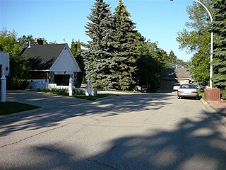
Richmond West is a suburb in the Waverley West area of southwest Winnipeg, Manitoba.

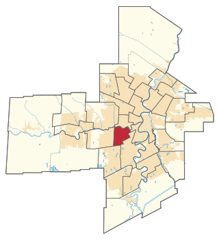
Waverley is a provincial electoral district (riding) in the Canadian province of Manitoba that came into effect at the 2019 Manitoba general election. It elects one member to the Legislative Assembly of Manitoba.
