West Kildonan, Winnipeg

Last updated
West Kildonan
Suburb
Winnipeg.jpg
Red pog.svg
West Kildonan
Coordinates: 49°55′59″N97°07′01″W / 49.933°N 97.117°W / 49.933; -97.117
Established1876
Rural Municipality1880
Incorporated as Town1921
Incorporated as a CityApril 1961
Area
  Suburb14.1 km2 (5.4 sq mi)
  Metro
5,306.79 km2 (2,048.96 sq mi)
Elevation
[1]
231 m (758 ft)
Population
 (2016)
  Suburb38,555
  Density2,700/km2 (7,100/sq mi)
   Metro
778,489
Time zone UTC-6 (CST)
  Summer (DST) UTC-5 (CDT)
Forward Sortation Area
R2V
Area code(s) Area codes 204 and 431

West Kildonan is a residential suburb within the Old Kildonan and Mynarski city wards of Winnipeg, Manitoba, lying on the west side of the Red River of the North, and immediately north of the old City of Winnipeg in the north-central part of the city.

Contents

It is bounded by the Red River on the east; the north limit of Kildonan Golf Course, Main Street, Seaforth Avenue, the Canadian Pacific Railway Winnipeg Beach Subdivision, and Templeton Avenue on the north; McPhillips Street on the west; and Carruthers Avenue, McGregor Street, and the lane between McAdam and Smithfield Avenues on the south.

It is notably home to Kildonan Park, West Kildonan Collegiate, and the former West Kildonan North Stars.

History

The Battle of Seven Oaks was fought in what is now West Kildonan in 1816. The area was part of the original Municipality of Kildonan, which was established in 1876. Kildonan was divided in eastern and western halves in 1914 and the more heavily developed areas of West Kildonan separated from areas which remained primarily rural (Old Kildonan) to assume the current boundaries in 1921. West Kildonan is one of Winnipeg's earliest residential suburbs.

The areas east of the CPR Winnipeg Beach tracks and south of Hartford Avenue were substantially developed by the 1910s and 1920s. West of the tracks, the Garden City neighbourhood was developed in the 1950s and 1960s, as was the area north of Hartford Avenue east of the tracks. The Garden Park community located north of Leila Avenue and west of the CPR tracks was developed beginning in the late 1950s.

The R.M.'s municipal hall was located at 1760 Main Street.

In January 1961 the Rural Municipality of West Kildonan asked the Province to designate it as a City. At the time the R.M. had a total tax assessment of C$15 million with a population of 19,000 citizens. [2] Final approval by the Manitoba Legislature was given in April 1961 for the R.M. of West Kildonan and the Town of Transcona to formally become cities via minor amendments to their respective municipal and provincial Acts. [3] The first council meeting operating as the City of West Kildonan took place on April 25, 1961. [4] Prior to 1972, it was the independent City of West Kildonan. Today, it is a popular suburb of the City of Winnipeg. [5]

Demographics

Early on, West Kildonan attracted many people from Winnipeg's working class North End who became more affluent beginning after World War I, but who wished to remain close to their roots. To this day, the area has a large Eastern European population.

This area, along with nearby Garden City are home to large portions of Winnipeg's Jewish population. Historically, the West Kildonan and Garden City areas have been two of Canada's largest Jewish neighbourhoods. Synagogues, Hebrew educational programming, Kosher supermarkets and Jewish cemeteries are common throughout the area. In recent years condominiums catering to the Jewish community have become increasingly popular.

See also

Related Research Articles

<span class="mw-page-title-main">Charleswood, Winnipeg</span> Suburb of Winnipeg

Charleswood is a residential community and neighbourhood in Winnipeg, Manitoba, Canada. It is located in the South-West of the city and is bordered by the neighbourhoods Tuxedo to the East, Fort Whyte to the South, and the Rural Municipality of Headingley on the West. Its boundaries are Roblin and the Assiniboine River to the north, Shaftesbury Boulevard on the East, Wilkes Avenue to the South and the Perimeter Highway to the West.

<span class="mw-page-title-main">East Kildonan, Winnipeg</span> Suburban community in southeast Manitoba.

East Kildonan is a primarily residential community in northeast Winnipeg, Manitoba, Canada. Commonly known by its initials EK, the suburb has a population of approximately 35,800 as of the 2016 Census.

<span class="mw-page-title-main">Transcona, Winnipeg</span> Suburb of Winnipeg

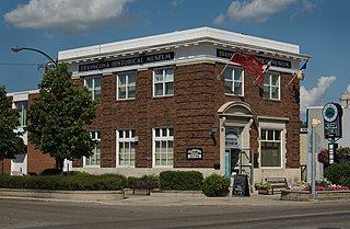
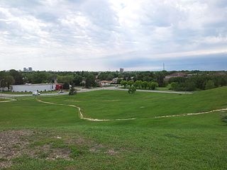
Transcona is a ward and suburb of Winnipeg, Manitoba, located about 10 kilometres (6.2 mi) east of the downtown area.

<span class="mw-page-title-main">Tuxedo, Winnipeg</span> Suburb of Winnipeg, Canada

Tuxedo is a residential suburb of Winnipeg, Manitoba. It is located about 7 kilometres southwest of downtown Winnipeg and borders the Assiniboine River and Assiniboine Park on the north, Shaftesbury Boulevard on the west, Route 90 to the East and McGillvary Boulevard to the South. Prior to 1972, the community was incorporated as the Town of Tuxedo.

<span class="mw-page-title-main">Wolseley, Winnipeg</span> Place in Manitoba, Canada

Wolseley is a neighbourhood located within the West End of Winnipeg, Manitoba. It is named for field marshal Sir Garnet Wolseley, a British Army officer who came to Manitoba in 1870 to suppress the Red River Rebellion. It is affectionately known as "The Granola Belt" of Winnipeg.

Old Kildonan is the northernmost city ward of Winnipeg, Manitoba. Before the City of Winnipeg Act of 1972, it was an independent unincorporated municipality called the Municipality of Old Kildonan; prior to that, from 1914, it was a subdivision of the Rural Municipality of Kildonan.

St. Vital is a ward and neighbourhood of Winnipeg, Manitoba, Canada.

North Kildonan is a city ward in northern Winnipeg, and a former municipality in Manitoba, Canada. Its population as of 2016 was 44,664.

<span class="mw-page-title-main">Osborne Village</span> Neighbourhood in Winnipeg, Manitoba, Canada

Osborne Village is a neighbourhood of Winnipeg, Manitoba. The area is bordered by the Assiniboine River on the north and west, Harkness Station on the east, and the Osborne Underpass on the south.

<span class="mw-page-title-main">St. James-Assiniboia, Winnipeg</span> Suburb in Winnipeg, Manitoba, Canada

St. James-Assiniboia is a major community area in Winnipeg, Manitoba, Canada. As it encapsulates most of the city ward of St. James, which includes the major St. James Street, the area itself is often simply referred to "St. James."

<span class="mw-page-title-main">West End, Winnipeg</span> Urban area in Manitoba, Canada

The West End is a mostly residential area of Downtown Winnipeg, Manitoba, Canada. It includes the neighbourhoods of Armstrong's Point, Colony, Daniel McIntyre, Minto, Sargent Park, Spence, St. Matthews, West Broadway, and Wolseley.

<span class="mw-page-title-main">North End, Winnipeg</span> Neighbourhood in Winnipeg, Manitoba, Canada

Winnipeg's North End is a large urban area located to the north and northwest of Downtown Winnipeg. It is bordered by the Red River on the east, the Canadian Pacific Railway (CPR) mainline on the south, the City of Winnipeg boundary on the west and Jefferson Avenue, Keewatin Street, Carruthers Avenue, McGregor Street and the lane between McAdam and Smithfield Avenues on the north. It is the northern section of the City of Winnipeg as it existed prior to the 1972 municipal amalgamation. Winnipeg's northern suburbs such as West Kildonan and Old Kildonan are not considered part of the North End. The CPR mainline and its Winnipeg yards, which are one of the largest railway yards in the world, act as a physical barrier between the North End and the rest of Winnipeg to the south. This has resulted in the North End remaining a very distinct and unique part of Winnipeg.

The municipal government of Winnipeg is represented by 15 city councillors and a mayor elected every four years.

<span class="mw-page-title-main">Elmwood, Winnipeg</span>

Elmwood is a primarily working-class residential area of Winnipeg, Manitoba. It is the only part of the historic city of Winnipeg located east of the Red River. It includes the areas of Glenelm, which is more affluent and lies west of Henderson Highway, most of Chalmers, Talbot-Grey, and East Elmwood, which was developed primarily in the 1950s. Elmwood is mostly composed of single family residential homes, though there are numerous low-rise apartment blocks, townhouses, and two high rise apartment complexes, which are both social housing projects.

Grant Park is a neighbourhood in the River Heights area of southern Winnipeg, Manitoba. Its general boundaries are Grant Avenue to the north, Stafford Street to the east, the CNR Mainline to the south, and Cambridge Street to the west.

Garden City is a suburban neighbourhood in Winnipeg, Manitoba.

<span class="mw-page-title-main">Winnipeg Route 62</span>

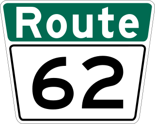
Route 62 is a major north–south arterial route in Winnipeg, Manitoba that has eight different street names.

Winnipeg, Manitoba, is subdivided in different ways for different purposes. The suburbs and neighbourhoods of Winnipeg take their names from former administrative districts, parishes, and geographic features.

References

  1. "Elevation at West Kildonan". earthtools.org.
  2. "W. K. To Seek City Status". Winnipeg Free Press. January 26, 1961. p. 30.
  3. "Final Approval Given 23 Bills by Legislature". Winnipeg Tribune. April 14, 1961. p. 32.
  4. "Pathways - West Kidonan". winnipeg.ca. Archived from the original on June 3, 2012.
  5. O'Shaughnessy, Michael (December 31, 1971). "West Kildonan, Scotland Linked With 1,300 Year-Old Name". Winnipeg Free Press. p. 20.