Main Street Queen Elizabeth Way St. Mary's Road | ||||
Route information | ||||
Maintained by City of Winnipeg | ||||
Length | 21.2 km [1] (13.2 mi) | |||
Existed | 1966–present | |||
Known for | Junction of Portage and Main | |||
Component highways | PTH 1 (Trans-Canada Highway) | |||
Major junctions | ||||
North end | PTH 9 north / Winnipeg city limits | |||
| ||||
South end | PTH 100 (TCH) (Perimeter Hwy) / PR 200 south (St. Mary's Rd) | |||
Location | ||||
Country | Canada | |||
Province | Manitoba | |||
Highway system | ||||
|
Route 52 is a major north-south arterial route in Winnipeg, Manitoba, Canada. It comprises all of Main Street, Queen Elizabeth Way, and St. Mary's Road.
Beginning at the northern city limits, the route runs south as Main Street along the west bank of the Red River. After passing through downtown, it becomes the Queen Elizabeth Way from the Main Street Bridge to the Norwood Bridge, over the Assiniboine and Red Rivers. South of the Norwood Bridge, it continues along the east side of the river as St. Mary's Road to the south Perimeter Highway. At the northern city limits, Route 52 becomes Manitoba Highway 9; at the south Perimeter Highway, it continues as Manitoba Provincial Road 200.
Route 52 passes through the suburbs of West Kildonan, the North End, Downtown, Fort Rouge, St. Boniface, and St. Vital. The section between Broadway and St. Anne's Road is part of Manitoba Highway 1, the Trans-Canada Highway.
Many of Winnipeg's most prominent buildings and institutions are located along Main Street, including City Hall, the Centennial Concert Hall, the Manitoba Museum, Union Station, the Richardson Building, and 360 Main (formerly the Commodities Exchange tower).
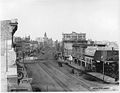
Main Street is one of the oldest routes in the Winnipeg region. It originated as the trail between Lower Fort Garry and the various settlements huddled around the confluence of the Red and Assiniboine Rivers. Its intersection with the Portage Trail near Upper Fort Garry (now downtown Winnipeg) spawned the Portage and Main corner, which is today the heart of the city. Upper Fort Garry was eventually demolished by the city in order to straighten the southern portion of Main Street and realign it to its current configuration. The north gate, the sole surviving piece of Upper Fort Garry, stands near the corner of Broadway and Main. [2]
St. Mary's Road is named after St. Mary's Parish (Ste. Marie Paroisse in French), a Roman Catholic parish located in the northernmost section of St. Vital. [3] It was originally a trail that led from the parish south to the United States border at Emerson along the east side of the Red River. In rural Manitoba, St. Mary's Road is now incorporated into Provincial Roads 200 and 246.
A short section of Main Street was renamed Queen Elizabeth Way to commemorate the 2002 Royal Visit of Queen Elizabeth II to the city. [4]
From north to south: [5]
Street Name | Location | km [1] | mi | Destinations | Notes |
---|---|---|---|---|---|
R.M. West St. Paul | −1.1 | −0.68 | PTH 9 north (Main Street) – Selkirk PTH 101 (Perimeter Highway) | Interchange; PTH 101 exit 71 | |
Main Street | West Kildonan | 0.0 | 0.0 | Winnipeg city limits | Continues as PTH 9 |
2.0 | 1.2 | Chief Peguis Trail (Route 17) | |||
3.3 | 2.1 | Leila Avenue (Route 23 west) | One-way westbound east of Main Street | ||
3.4 | 2.1 | Partridge Avenue (Route 23 east) | One-way eastbound (no access, T-intersection) | ||
5.1 | 3.2 | Inkster Boulevard | |||
6.4 | 4.0 | Redwood Avenue (Route 37) | |||
Downtown | 7.8 | 4.8 | Higgens Avenue | ||
8.1 | 5.0 | Logan Avenue (Route 47) to Route 42 east | |||
8.2 | 5.1 | Disraeli Freeway / Alexander Avenue (Route 42) | No southbound to eastbound exit; Alexander Avenue is one-way, westbound; north end of Route 42 east concurrency | ||
8.4 | 5.2 | James Avenue (Route 42 east) | One-way eastbound (no access, T-intersection); south end of Route 42 east concurrency | ||
8.6 | 5.3 | Bannatyne Avenue | One-way, westbound | ||
8.7 | 5.4 | McDermot Avenue | One-way, eastbound | ||
8.9 | 5.5 | Portage Avenue (Route 57) / Route 85 west to PTH 1 (TCH) | See Portage and Main Eastern terminus of Yellowhead Highway | ||
9.0 | 5.6 | Pioneer Avenue | One-way, westbound (no access, T-intersection) | ||
9.1 | 5.7 | To Route 57 east / William Stephenson Way – The Forks | One-way, eastbound | ||
9.2 | 5.7 | Graham Avenue | |||
9.3 | 5.8 | St. Mary Avenue | One-way, westbound | ||
9.5 | 5.9 | York Avenue – The Forks | One-way eastbound west of Main Street | ||
9.7 | 6.0 | Broadway (PTH 1 (TCH) west) – Union Station, Manitoba Legislative Building | North end of PTH 1 concurrency | ||
Assiniboine River | 10.1– 10.2 | 6.3– 6.3 | Main Street Bridge Main Street south end • Queen Elizabeth Way north end | ||
Queen Elizabeth Way | Fort Rouge | 10.2 | 6.3 | Mayfair Avenue | One-way eastbound (no access, T-intersection); northbound entrance from Stradbrook Avenue |
10.3 | 6.4 | River Avenue (via Stradbrook Avenue) | No northbound entrance; Stradbrook Avenue alignment, signed as River Avenue | ||
Red River | 10.4– 10.6 | 6.5– 6.6 | Norwood Bridge Queen Elizabeth Way south end • St. Mary's Road north end | ||
St. Mary's Road | St. Boniface | 10.7 | 6.6 | Marion Street (Route 115 east) | No northbound access |
11.3 | 7.0 | Tache Avenue / Enfield Cresecent | Northbound access to Route 115 east | ||
St. Vital | 13.1 | 8.1 | PTH 1 (TCH) east / St. Anne's Road (Route 150 south) | South end of PTH 1 concurrency | |
14.4 | 8.9 | Fermor Avenue (Route 135) to PTH 1 (TCH) east | |||
16.3 | 10.1 | Dunkirk Drive / Dakota Street (Route 62) | |||
16.9 | 10.5 | Abinojii Mikanah (Route 165) | |||
17.6 | 10.9 | Meadowood Drive – St. Vital Centre | |||
21.2 | 13.2 | Perimeter Highway (PTH 100 (TCH)) PR 200 south (St. Mary's Road) – St. Adolphe | Continues as PR 200 | ||
1.000 mi = 1.609 km; 1.000 km = 0.621 mi
|
Fort Garry, also known as Upper Fort Garry, was a Hudson's Bay Company trading post at the confluence of the Red and Assiniboine rivers in what is now downtown Winnipeg.
Provincial Trunk Highway 1 is Manitoba's section of the Trans-Canada Highway. It is a heavily used, 4-lane divided highway, with the exception of a short 18 km section in the southeastern corner of the province. It is the main link between southern Manitoba's largest cities, and also serves as the province's main transportation link to the neighbouring provinces of Saskatchewan and Ontario. The highway is the only major east-west divided highway in Manitoba, and carries a large majority of east-west traffic within and through the province. It has full freeway status sections at Portage la Prairie and Winnipeg. The total distance of the Trans-Canada Highway in Manitoba is approximately 490 km (300 mi).
Provincial Trunk Highway 9 is a provincial primary highway located in the Canadian province of Manitoba. It runs from Winnipeg north to Gimli.
Route 165, also known as Abinojii Mikanah is a highway in Winnipeg, Manitoba. It was formerly known as Bishop Grandin Boulevard, but was renamed in March 2023.
Route 150, locally known as St. Anne's Road, is a major arterial route in Winnipeg, Manitoba, Canada.
Route 30 is a city route in Winnipeg, Manitoba. It runs from Highway 1/Route 135 to Route 37.
Route 70 is a city route in Winnipeg, Manitoba, Canada. It runs from Route 57 to Route 42.
Fort Rouge is a district of Winnipeg, Manitoba, in Canada. Located in the south-central part of the city, it is bounded on the north by the Assiniboine River, on the east and south by the Red River, and on the west by Stafford Street and Pembina Highway.
Route 85, also known as Portage Avenue, is a major arterial route in the city of Winnipeg, Manitoba, Canada. It is one of the city's oldest and most important roads and is part of both the Trans-Canada and Yellowhead Highways.
Route 80, locally known as Waverley Street, is a major arterial road in the southwest portion of Winnipeg, Manitoba, Canada. It runs from Kenaston Boulevard to Grant Avenue.
Downtown Winnipeg is an area of Winnipeg located near the confluence of the Red and Assiniboine rivers. It is the oldest urban area in Winnipeg, and is home to the city's commercial core, city hall, the seat of Manitoba's provincial government, and a number of major attractions and institutions.
Route 95 is a city route located in Winnipeg, Manitoba. It runs in the southwest part of the city from Route 105 east to Route 42, near the Confusion Corner intersection. It is named Roblin Boulevard west of Assiniboine Park, where it then becomes Corydon Avenue for the remainder of its route.
Route 115 is a major east-west arterial route in the Winnipeg suburbs of St. Boniface and Transcona. It is the western extension of Manitoba Highway 15, which runs eastward to the communities of Dugald and Elma, Manitoba. Within the city boundaries it connects the largely industrial areas of south Transcona and east St. Boniface with Old St. Boniface and downtown.
Route 90 is a major north-south arterial route in Winnipeg, Manitoba, Canada. It begins at the South Perimeter Highway and ends at the city's northwest limit, where it continues north as PTH 7. Route 90 is designated as the city's airport route, as it passes by Winnipeg James Armstrong Richardson International Airport.
Route 42 is a major arterial road located in Winnipeg, Manitoba.
Route 62 is a major north–south arterial route in Winnipeg, Manitoba that has eight different street names.
Route 37 is a major east-west arterial route in Winnipeg, Manitoba which connects the suburbs of Transcona and Elmwood with the downtown core.
Route 105 is a major east-west arterial route in the city of Winnipeg. It runs through the suburbs of Fort Rouge, River Heights, Tuxedo, and Charleswood. It is the eastern extension of Provincial Road 241, which runs westward to the communities of Headingley and Lido Plage. Within the city boundaries it connects the residential and light industrial areas west-southwest of downtown with the Pembina Highway and downtown.
Broadway is a street in the city of Winnipeg, Manitoba, Canada. It is one of the city's oldest and most historic routes and forms the Trans-Canada Highway route through the city's downtown.
Route map: