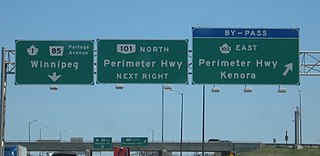
Provincial Trunk Highways (PTH) 100 and 101, collectively known as the Perimeter Highway, form a beltway around the Canadian city of Winnipeg, Manitoba. The Perimeter Highway is approximately 90 kilometres (56 mi) in length and serves as a ring road around Winnipeg for through traffic. It is often considered by local residents to be the city's unofficial boundary, although approximately three-quarters of the Perimeter Highway actually lies in the other municipalities within the Winnipeg Metropolitan Region.
Provincial Trunk Highway 59 is a major provincial highway in the Canadian province of Manitoba. It runs from the Lancaster-Tolstoi Border Crossing, through the city of Winnipeg, north to 8th Avenue in Victoria Beach on Lake Winnipeg.
Provincial Trunk Highway 75 is a major highway in the Canadian province of Manitoba. It is the main link between the city of Winnipeg and the United States border, where it connects with Interstate 29/U.S. Route 81.
Provincial Trunk Highway 6 is a provincial primary highway located in the Canadian province of Manitoba. It runs from the Perimeter Highway of Winnipeg to the Thompson south city limits. It is also the main highway connecting Winnipeg to northern Manitoba. The speed limit is 100 km/h. The route is also used to deliver nickel from the Thompson mine to the Royal Canadian Mint in Winnipeg. The section of highway between its southern terminus near Winnipeg and the second junction with PTH 68 near Eriksdale is part of the Northern Woods and Water Route. The portion of the highway between Ponton and Thompson was known as Highway 391 prior to 1986.
Provincial Trunk Highway 9 is a provincial primary highway located in the Canadian province of Manitoba. It runs from Winnipeg north to Gimli.
Provincial Trunk Highway 8 is a provincial primary highway located in the Canadian province of Manitoba. It runs from the north limit of the City of Winnipeg, where it meets with Route 180, north to Hecla-Grindstone Provincial Park. The highway between Winnipeg and PR 230 is known as McPhillips Street. At PR 230, McPhillips Street becomes McPhillips Road and continues along PR 230 to PTH 9. The route is a major road connecting Winnipeg with the communities of Winnipeg Beach and Gimli. The speed limit is 100 km/h (60 mph).

Provincial Trunk Highway 2 is a 315-kilometre (196-mile) highway in the Canadian province of Manitoba. It runs from Highway 13 at the Manitoba-Saskatchewan border to Winnipeg's Perimeter Highway near Oak Bluff.

Provincial Trunk Highway 3 (PTH 3) is a major provincial highway located in the Canadian province of Manitoba. It runs from the Saskatchewan boundary to the southwest city limits of Winnipeg, where it continues as Winnipeg Route 155. Prior before to the implementation of Winnipeg's City Route System, it extended to Pembina Highway.
Provincial Trunk Highway 39 is a provincial highway in the Canadian province of Manitoba. It runs from PTH 6 to PTH 10.

Provincial Trunk Highway 10 is a provincial primary highway located in the Canadian province of Manitoba.
Provincial Trunk Highway 23 is a major east-west provincial highway in the southern portion of the Canadian province of Manitoba. It runs from PTH 21 just south of Hartney to PTH 59 in La Rochelle. Along its route, PTH 23 passes through the communities of Elgin, Ninette, Baldur, Miami, Lowe Farm, and Morris.
Provincial Trunk Highway 44 is an east-west provincial highway in the Eastman Region of the Canadian province of Manitoba.

Provincial Road 200 is a provincial road in Manitoba. It runs from the Perimeter Highway at Winnipeg to the border town of Emerson, ending at Manitoba Highway (PTH) 75 at Emerson, near the Canada–United States border.
Provincial Trunk Highway 24 is a provincial highway in the Canadian province of Manitoba. It is an east–west route that runs from PTH 83 near Miniota, east through Oak River and Rapid City to the junction of PTH 10 and PR 262 between Brandon and Minnedosa.
Provincial Trunk Highway 22 is a short north-south provincial highway in the Canadian province of Manitoba. It runs from PTH 23 near Elgin to PTH 2 and PR 250 in Souris. This highway is the main access road to the renowned Souris Swinging Bridge.

Provincial Road 210 is a 117.2-kilometre-long (72.8 mi) provincial road in the Eastman Region of southeastern Manitoba, Canada. It serves to connect the towns and communities of Woodridge, Marchand, La Broquerie, Ste. Anne, Landmark, Linden, Île-des-Chênes, and St, Adolphe with PTH 12, PTH 59, and PTH 75.

Provincial Road 201 is an east–west provincial road in southern Manitoba, Canada. The road runs parallel to Manitoba's border with the United States for a distance of 218 kilometres (135 mi), nearly half the province's length.

Provincial Road 205 is a 84.7-kilometre-long (52.6 mi) provincial road in the Canadian province of Manitoba. Spanning the Pembina Valley and Eastman regions in the south, it connects the communities of Sperling, Rosenort, Aubigny, St. Pierre-Jolys, and Grunthal with PTH 75, while also spanning the Red River.

Provincial Road 243 is an east-west provincial road in the Pembina Valley Region of the Canadian province of Manitoba. It runs from PTH 75 near Emerson to PTH 32 near Friedensfeld West. Along the route, it passes north of Gretna using a small concurrence with PTH 30.

Provincial Road 247 is a 68.2-kilometre-long (42.4 mi) east-west highway in the Central Plains and Eastman regions of Manitoba, Canada. It serves to connect the hamlets of Elm Creek, Sanford, La Salle, and Howden, including two crossings of the La Salle River. The majority of the highway is gravel.


