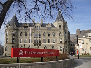
Winnipeg is the capital and largest city of the province of Manitoba in Canada. It is centred on the confluence of the Red and Assiniboine rivers, near the longitudinal centre of North America. As of 2021, Winnipeg had a city population of 749,607 and a metropolitan population of 834,678, making it Canada's sixth-largest city and eighth-largest metropolitan area.

Winnipeg South Centre is a federal electoral district in Manitoba, Canada, that has been represented in the House of Commons of Canada from 1925 to 1979 and since 1988.
Howard Beach is a neighborhood in the southwestern portion of the New York City borough of Queens. It is bordered to the north by the Belt Parkway and Conduit Avenue in Ozone Park, to the south by Jamaica Bay in Broad Channel, to the east by 102nd–104th Streets in South Ozone Park, and to the west by 75th Street in East New York, Brooklyn. The area consists mostly of low-rise single-family houses.

Charleswood is a semi-rural residential community and neighbourhood in Winnipeg, Manitoba, Canada. It is located in the South-West of the city and is bordered by the neighbourhoods Tuxedo to the East, Fort Whyte to the South, and the Rural Municipality of Headingley on the West. It's boundaries are Roblin and the Assiniboine River to the north, Shaftesbury Boulevard on the East, Wilkes Avenue to the South and the Perimeter Highway to the West.

Tuxedo is a residential suburb of Winnipeg, Manitoba. It is located about 7 kilometres southwest of downtown Winnipeg and borders the Assiniboine River and Assiniboine Park on the north, Shaftesbury Boulevard on the west, Route 90 to the East and McGillvary Boulevard to the South. Prior to 1972, the community was incorporated as the Town of Tuxedo.
River Heights is a suburb and community area in Winnipeg, Manitoba. It is bordered by Route 90 to the west, the Assiniboine River to the north, Cambridge Street to the east, and Taylor Avenue to the south.

Fort Rouge is a district of Winnipeg, Manitoba, in Canada. Located in the south-central part of the city, it is bounded on the north by the Assiniboine River, on the east and south by the Red River, and on the west by Stafford Street and Pembina Highway.

Osborne Village is a neighbourhood of Winnipeg, Manitoba. The area is bordered by the Assiniboine River on the north and west, Harkness Station on the east, and the Osborne Underpass on the south.

The West End is a mostly residential area of Downtown Winnipeg, Manitoba, Canada. It includes the neighbourhoods of Armstrong's Point, Colony, Daniel McIntyre, Minto, Sargent Park, Spence, St. Matthews, West Broadway, and Wolseley.

Winnipeg's North End is a large urban area located to the north and northwest of Downtown Winnipeg. It is bordered by the Red River on the east, the Canadian Pacific Railway (CPR) mainline on the south, the City of Winnipeg boundary on the west and Jefferson Avenue, Keewatin Street, Carruthers Avenue, McGregor Street and the lane between McAdam and Smithfield Avenues on the north. It is the northern section of the City of Winnipeg as it existed prior to the 1972 municipal amalgamation. Winnipeg's northern suburbs such as West Kildonan and Old Kildonan are not considered part of the North End. The CPR mainline and its Winnipeg yards, which are one of the largest railway yards in the world, act as a physical barrier between the North End and the rest of Winnipeg to the south. This has resulted in the North End remaining a very distinct and unique part of Winnipeg.

South Ozone Park is a neighborhood in the southwestern section of the New York City borough of Queens. It is just north of John F. Kennedy International Airport, between Aqueduct Racetrack to the west and the Van Wyck Expressway to the east. Adjacent neighborhoods include Ozone Park to the west; Richmond Hill to the north; Jamaica, South Jamaica, and Springfield Gardens to the east; and Howard Beach and Old Howard Beach to the southwest.
The municipal government of Winnipeg is represented by 15 city councillors and a mayor elected every four years.

Elmwood is a primarily working-class residential area of Winnipeg, Manitoba. It is the only part of the historic city of Winnipeg located east of the Red River. It includes the areas of Glenelm, which is more affluent and lies west of Henderson Highway, most of Chalmers, Talbot-Grey, and East Elmwood, which was developed primarily in the 1950s. Elmwood is mostly composed of single family residential homes, though there are numerous low-rise apartment blocks, townhouses, and two high rise apartment complexes, which are both social housing projects.
Varsity View is one of the original neighbourhoods of the Charleswood community in Winnipeg, Manitoba, Canada, and also a part of the Assiniboine South neighbourhood cluster.
North Point Douglas is a small neighbourhood located in the city of Winnipeg, Manitoba, Canada.

Central Park is a large urban park located in downtown Winnipeg, and forms the heart of the neighbourhood of the same name.
Whyte Ridge is a residential area in the Waverley West ward in the southwest corner of Winnipeg, Manitoba, Canada.
Windsor Park is a neighborhood in the southeastern part of St. Boniface, a neighbourhood of Winnipeg, Manitoba, Canada. It is bordered by Marion Street on the north, Archibald Street on the west, Lagimodière Boulevard on the east, and Fermor Avenue on the south. Its main thoroughfares include Autumnwood Drive, Drake Boulevard, Cottonwood Road, and Maginot Street.

Centennial is an inner-city neighbourhood located Winnipeg, Manitoba, Canada, in the Downtown East Neighbourhood Cluster. The boundaries of Centennial are Sherbrook Street on the west, Logan Avenue on the north, William Avenue on the south and Stanley, Paulin and Adelaide streets on the east.

Wellington Crescent is an affluent neighbourhood in Winnipeg, Manitoba, Canada. It is known for its stately homes and for a small commercial area along Academy Road.
