Whyte Ridge, Winnipeg

Last updated
Whyte Ridge
Neighbourhood
Winnipeg.jpg
Red pog.svg
Coordinates: 49°48′47″N97°12′25″W / 49.813°N 97.207°W / 49.813; -97.207
Country Flag of Canada (Pantone).svg  Canada
Province Flag of Manitoba.svg  Manitoba
City Winnipeg
Named for William Whyte
Government
  CouncillorJanice Lukes (Waverley West)
Area
  Neighbourhood2.8 km2 (1.1 sq mi)
  Metro
5,306.79 km2 (2,048.96 sq mi)
Elevation
[1]
232 m (761 ft)
Population
 (2016)
  Neighbourhood7,690
  Density2,700/km2 (7,100/sq mi)
   Metro
778,489
Time zone UTC-6 (Central Standard Time)
  Summer (DST) UTC-5 (Central Daylight Time)
Forward sortation area
R3Y
Area code(s) Area codes 204 and 431

Whyte Ridge is a residential area in the Waverley West ward in the southwest corner of Winnipeg, Manitoba, Canada.

Contents

The subdivision was built on former farmland, just south of a small townsite that was historically known as Fort Whyte. The first homes in the subdivision were constructed in 1986. The final homes in the subdivision were constructed in 2007, making a total of approximately 1,500 homes.[ when? ]

History

The name of Whyte Ridge was derived from William Whyte, who led a "bloodless battle" over railway rights in 1888 on land that is adjacent to the current-day neighbourhood. [2]

Subsequent to the battle of Fort Whyte, a small townsite called Fort Whyte appeared, which included a few dozen homes and a grain elevator. (The grain elevator burned to the ground in March 2000, but the original homes of the townsite are still found in Whyte Ridge along McGillivray Boulevard, just to the north of the newer subdivision.)

Effective October 2018, Whyte Ridge became part of the Waverley West city ward.

Demographics

According to the 2016 Census, there are 7,690 people living in Whyte Ridge. [3] Whyte Ridge is one of Winnipeg's wealthier neighbourhoods, the average household income is $86,534, which is about 1.7 times greater than the average income across the whole city.

Racial groups in Whyte Ridge, Winnipeg [4]
Population groupPopulation (2006) % of total population (2006)
White 5,925
Visible minority group South Asian 445
East Asian 565
Black 90
Latin American 20
Arab & West Asian 50
Southeast Asian 255
Other10
Multiracial 50
Total visible minority population1,485
Aboriginal group First Nations 75
Métis 70
Inuit 10
Aboriginal, n.i.e.0
Multiple Aboriginal identities0
Total Aboriginal population155
Total population7,565100%

Community and amenities

Two large man-made lakes—simply named East Lake and West Lake—were excavated for the development and a ridge was created from the earth that was removed. While no fish have been stocked in either lake, because they drain out to the Red River through underground pipes, fish have made their way into the lakes. Brown bullhead, carp and northern pike are some of the species of fish that have been identified in the lakes. The lakes are also a popular place for Canada geese, pelicans, mallard ducks, coots, and other assorted fowl, many of which come to Whyte Ridge from the nearby FortWhyte Alive Wildlife Centre.

The neighbourhood contains an elementary school (kindergarten to grade 4) called Whyte Ridge School, [5] and a middle school (grades 5–9) called Henry G. Izatt ("HGI") School. [6] Both schools are found on Scurfield Boulevard, and have full-sized soccer fields and basketball hoops which are used by the community. In addition, HGI sports a softball diamond on its grounds.

Whyte Ridge Community Center, [7] located on Fleetwood Road, currently contains a clubhouse, toboggan slide, full sized soccer field, tyke sized soccer field, outdoor basketball court and outdoor hockey rink, along with two parking lots. Further development of the community centre site is in the planning stages.[ when? ]

The neighbourhood has five playgrounds: one is found adjacent to the community centre on Cloverwood Road, one is found near HGI School adjacent to the softball diamond, two are found at Whyte Ridge Elementary School, and one is found to the south of the East Lake, on Columbia Drive.

The neighbourhood currently has one church, namely the Whyte Ridge Baptist Church [8] on Scurfield Boulevard at Apple Hill Road. The church congregation has bought land north of Whyte Ridge on McGillivray Boulevard, where a larger church was planned.[ when? ] In addition, St. Gianna Beretta Molla Roman Catholic Parish [9] was completed on vacant land that borders McGillivray Boulevard, Columbia Drive and Scurfield Boulevard. Lastly, a Presbityrian church was planned next door to St. Gianna's, also on McGillivray. There is no estimated time of construction for any of these churches.

Whyte Ridge residents of note include World Champion curler Cathy Overton-Clapham.

Crime

All rates per 100,000

Whyte Ridge is one of Winnipeg's safest neighbourhoods. Crime rates are very low.

Whyte Ridge, Winnipeg - Crime Rates [10]
Year Homicide Sexual Assault Shooting Robbery - CommercialRobbery - Non-CommercialBreak and Enter - CommercialBreak and Enter - ResidentialBreak and Enter - OtherMotor Theft - AttemptMotor Theft - Actual
2012000026.4052.9119.0052.9

See also

Related Research Articles

<span class="mw-page-title-main">Lake in the Hills, Illinois</span> Village in Illinois, United States

Lake in the Hills is a village in McHenry County, Illinois, United States. As of the 2020 census, the population was 28,982.

Riverview is a neighbourhood in Ottawa, Ontario, Canada. It is southeast of the downtown adjacent to the Rideau River, its location on which is its namesake. The 2021 Census population of Riverview is 13,113.

<span class="mw-page-title-main">Charleswood, Winnipeg</span> Suburb of Winnipeg

Charleswood is a semi-rural residential community and neighbourhood in Winnipeg, Manitoba, Canada. It is located in the South-West of the city and is bordered by the neighbourhoods Tuxedo to the East, Fort Whyte to the South, and the Rural Municipality of Headingley on the West. It's boundaries are Roblin and the Assiniboine River to the north, Shaftesbury Boulevard on the East, Wilkes Avenue to the South and the Perimeter Highway to the West.

<span class="mw-page-title-main">Winnipegosis</span> Unincorporated urban community in Manitoba, Canada

Winnipegosis is an unincorporated urban community in the Rural Municipality of Mossey River, Manitoba, Canada. It lies at the mouth of the Mossey River on Lake Winnipegosis in west-central Manitoba.

<span class="mw-page-title-main">Transcona, Winnipeg</span> Suburb of Winnipeg

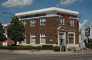
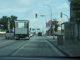
Transcona is a ward and suburb of Winnipeg, Manitoba, located about 10 kilometres (6.2 mi) east of the downtown area.

Old Kildonan is the northernmost city ward of Winnipeg, Manitoba. Before the City of Winnipeg Act of 1972, it was an independent unincorporated municipality called the Municipality of Old Kildonan; prior to that, from 1914, it was a subdivision of the Rural Municipality of Kildonan.

<span class="mw-page-title-main">Fort Garry, Winnipeg</span> Suburb of Winnipeg, Canada

Fort Garry is a community area and neighbourhood of Winnipeg, Manitoba, Canada, located in the southwestern part of the city, south of the district of Fort Rouge and east of the Tuxedo area. It comprises parts of the city wards of River Heights - Fort Garry, Fort Rouge - East Fort Garry, Waverley West, and St. Norbert - Seine River.

<span class="mw-page-title-main">The Queensway–Humber Bay</span> Neighbourhood in Toronto, Ontario, Canada

The Queensway–Humber Bay, known officially as Stonegate–Queensway, is a neighbourhood in the southwest of Toronto, Ontario, Canada. It is located in the southeast area of the former City of Etobicoke.

Waverley West is a city ward and suburb in southwest Winnipeg, Manitoba.

Midnapore is a community within the City of Calgary in the province of Alberta, Canada. It is bounded to the north and east by Fish Creek Provincial Park, to the south by Sun Valley Boulevard and to the west by Macleod Trail.

Scenic Acres is a residential neighbourhood in the northwest quadrant of Calgary, Alberta. It is bounded to the north by Crowchild Trail, to the east by Nose Hill Drive, to the west by Stoney Trail and to the south by Nose Hill Drive.

Parkview is a residential neighbourhood in west Edmonton, Alberta, Canada. Parkview is one of the larger residential neighbourhoods in the city, and is located adjacent to the North Saskatchewan River Valley in the west portion of the City. The neighbourhood has good access to Whitemud Drive and Stony Plain Road, and the interior street layout is based on a modified grid network.

The city of Sault Ste. Marie, Ontario, Canada contains a significant number of named residential neighbourhoods, including Bayview, Broadview Gardens, Brookfield, Buckley, Carpin Beach, Cedar Heights, East Korah, Eastside, Fort Creek, Grandview Gardens, Korah, Manitou Park, McQueen, Meadow Park, Nokomis Beach, Odena, The P Patch, Pointe aux Pins, Pointe des Chênes, Pointe Louise and Steelton.

Kings Park is a 92 acres (37.4 ha) park and residential subdivision in Fort Richmond, a suburb of Fort Garry in southern Winnipeg, located on the western side of the Red River. Its grounds include Chinese pagoda gardens in the centre of the park, a soccer field, two baseball diamonds, an off leash dog park area and marshland, home of waterfowl and wildlife.

<span class="mw-page-title-main">Linden Woods, Winnipeg</span> Neighbourhood in Winnipeg, Manitoba, Canada

Linden Woods is a neighbourhood in the Fort Garry area of southwest Winnipeg, Manitoba, Canada.

<span class="mw-page-title-main">Riverstone, Texas</span> Master-Planned Community in Sugar Land and Missouri City, Texas

Riverstone is a 3,700-acre (15 km2) upscale master-planned residential community in Fort Bend County, Texas. About 18,000 residents ultimately will live in 6000 homes. The development is largely located in the unincorporated areas of Sugar Land and Missouri City, with a portion being in Missouri City proper.

Winnipeg, Manitoba, is subdivided in different ways for different purposes. The suburbs and neighbourhoods of Winnipeg take their names from former administrative districts, parishes, and geographic features.

Rockwood is a neighbourhood in the River Heights area of south-central Winnipeg, Manitoba.

Richmond West is a suburb in the Waverley West area of southwest Winnipeg, Manitoba.

References

  1. "Elevation at Whyte Ridge". earthtools.org.
  2. Siamandas, George (October 19, 2015). "Fort Whyte". Siamandas.com. Retrieved October 29, 2019.
  3. "2016 Census Data - Whyte Ridge" (PDF). Winnipeg.ca. July 24, 2019. Retrieved October 29, 2019.
  4. "2006 Census Data - Whyte Ridge" (PDF). Retrieved 2023-10-18.
  5. Whyte Ridge Elementary
  6. Henry G Izatt Middle School
  7. Whyte Ridge Community Center
  8. Whyte Ridge Baptist Church
  9. St. Gianna Roman Catholic Church
  10. "CrimeMaps".