
Broward County is a county in the southeastern part of Florida, located in the Miami metropolitan area. It is Florida's second-most populous county after Miami-Dade County and the 17th-most populous in the United States, with 1,944,375 residents as of the 2020 census. Its county seat and most populous city is Fort Lauderdale, which had a population of 182,760 as of 2020.

Fort Lauderdale is a coastal city located in the U.S. state of Florida, 30 miles (48 km) north of Miami along the Atlantic Ocean. It is the county seat of and most populous city in Broward County with a population of 182,760 at the 2020 census, making it the tenth-most populous city in Florida. After Miami and Hialeah, Fort Lauderdale is the third-most populous city in the Miami metropolitan area, which had a population of 6,166,488 in 2019.
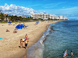
Lauderdale-by-the-Sea is a town in Broward County, Florida, United States, situated 33 miles north of Miami. The town is part of the South Florida metropolitan area. As of the 2020 census, the population was 6,198.

Hillsboro Inlet Lighthouse is a lighthouse located on the north side of Hillsboro Inlet, midway between Fort Lauderdale and Boca Raton, in Hillsboro Beach, Florida. The light marks the northern limit of the Florida Reef, an underwater coral formation on the lower east coast of the state.

The Davie School is a historic school in Davie, Florida, USA. It is located at 6650 Griffin Road. It was designed by August Geiger. It opened its doors in 1918 to 90 students, and was in continuous use as a school until 1978. On March 29, 1988, it was added to the U.S. National Register of Historic Places. It is the oldest extant school building in Broward County.
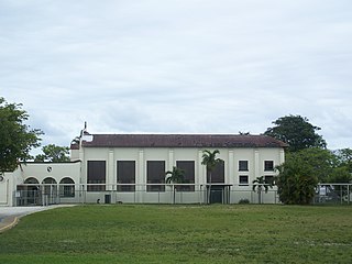
The Oakland Park Elementary School is a historic school in Oakland Park, Florida, United States. The school, part of Broward County Public Schools, is located at 936 Northeast 33rd Street. On June 9, 1988, it was added to the U.S. National Register of Historic Places. As of 2016 the principle of the school is Michelle Garcia. The mascot of the school is an eagle. Grades are Pre-K, K, 1st, 2nd, 3rd, 4th, and 5th. There are English for Speakers of Other Languages students in this school who typically natively speak Spanish or Creole.
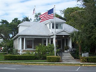
The Nyberg-Swanson House is a historic home in Dania Beach, Florida. It is located at 102 West Dania Beach Boulevard. On May 28, 1999, it was added to the U.S. National Register of Historic Places.

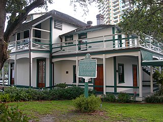
The Bonnet House is a historic home in Fort Lauderdale, Florida, United States. It is located at 900 Birch Road. On July 5, 1984, it was added to the U.S. National Register of Historic Places. It is named after the Bonnet Lily.
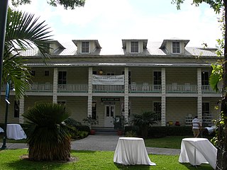
Stranahan House is the home of Fort Lauderdale pioneers Frank and Ivy Stranahan. Built in 1901 as a trading post and converted into a residence for the Stranahans in 1906, the house is the oldest surviving structure in Broward County. It was placed on the National Register of Historic Places in 1973 and today operates as a historic house museum. The House is open for guided tours at 1, 2, or 3 p.m. most Tuesdays through Fridays, and hosts special events throughout the year. Check their website for availability.

The Bryan Building, which has also been known as the Shepherd Building and as the DeSoto Hotel, is a historic site in Fort Lauderdale, Florida. It is located at 220-230 Brickell Avenue. In 1997 it was added to the U.S. National Register of Historic Places.
The New River Inn is a historic site in Fort Lauderdale, Florida located at 231 Southwest 2nd Avenue.

The Deerfield Beach Elementary School is a historic school in Deerfield Beach, Florida. It is located at 651 Northeast 1st Street and is in the Broward County Public Schools school district. On April 16, 1990, it was added to the United States National Register of Historic Places.

St. Anthony Catholic School is a historic school in Fort Lauderdale, Florida. It is located at 820 Northeast 3rd Street. Saint Anthony Catholic School is the parochial Catholic school of St. Anthony Catholic Church in Broward County. On September 26, 1997, it was added to the U.S. National Register of Historic Places. The school building was built in 1926 by John Olsson. The architect was Francis Abreu.
The Sam Gilliam House is a historic home in Fort Lauderdale, Florida. It is located at 11 Southwest 15th Street. On March 29, 2001, it was added to the U.S. National Register of Historic Places.
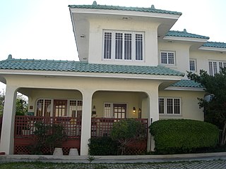
The Dr. Willard Van Orsdel King House is an historic U.S. home in Fort Lauderdale, Florida. It is located at 1336 Seabreeze Boulevard. It was built in 1951 and is an architectural example of the Mid-century modern design movement. On February 21, 2006, it was added to the U.S. National Register of Historic Places.
The history of Fort Lauderdale, Florida began more than 4,000 years ago with the arrival of the first aboriginal natives, and later with the Tequesta Indians, who inhabited the area for more than a thousand years. Though control of the area changed among Spain, England, the United States, and the Confederate States of America, it remained largely undeveloped until the 20th century. The first settlement in the area was the site of a massacre at the beginning of the Second Seminole War, an event which precipitated the abandonment of the settlement and set back development in the area by over 50 years. The first United States stockade named Fort Lauderdale was built in 1838, and subsequently was a site of fighting during the Second Seminole War. The fort was abandoned in 1842, after the end of the war, and the area remained virtually unpopulated until the 1890s.

The New River is a tidal estuary in South Florida, United States. Despite its name, it is not a river, but a channel composed of many tributary canals, The channel is connected to the Everglades through a series of man-made canals. After passing through Fort Lauderdale, the channel connects to the Intracoastal Waterway and Atlantic Ocean at Port Everglades cut. The channel is entirely within Broward County and is composed from the junction of three main canals which originate in the Everglades, splitting off from the Miami Canal. They are the North New River Canal, which flows south from Lake Okeechobee along the east side of U.S. 27 and then east along the north side of State Road 84 / Interstate 595; the South New River Canal, which flows east from the Miami Canal along the north side of Griffin Road and the south side of Orange Drive; and a canal which flows east along the south side of Sunrise Boulevard.
On March 16–17, 1983, a significant severe weather event affected the island of Cuba and the southern Florida peninsula, including the Miami metropolitan area. A total of at least four tornadoes affected these regions; while as many as 17 were reported in South Florida, only two were confirmed in the official National Weather Service records. The strongest tornado produced F2 damage on the Fujita scale and skipped across the Everglades region from the eastern Big Cypress National Preserve through the Everglades and Francis S. Taylor Wildlife Management Area to Lighthouse Point—a path length of nearly 53 mi (85 km). An F1 tornado also affected Naples and Golden Gate. Additionally, unconfirmed tornadoes affected an RV park southeast of East Naples, as well as the Stuart and Jupiter areas, respectively. In addition to tornadoes, severe thunderstorms produced hail to 1 in (2.5 cm) in diameter, as well as rainfall totals of 1 to 2 in in some areas.

The Snow-Reed Swing Bridge is one of the oldest bridges in the Fort Lauderdale area, and one of the few remaining swing bridges in Florida. Located between the 300 and 500 block of Southwest 11th (Palm) Avenue in Fort Lauderdale, Florida, the bridge connects the neighborhoods of Sailboat Bend and Riverside Park. In 1989 it was officially renamed and designated a historic landmark.
The following is a timeline of the history of the city of Fort Lauderdale, Florida, USA.

