Croix-des-Bouquets Arrondissement

Last updated
Croix-des-Bouquets Arrondissement
Kwadèbouke Awondisman
Arrondissement
Country Flag of Haiti.svg  Haiti
Department Ouest
Area [1]
   Arrondissement 1,930.17 km2 (745.24 sq mi)
  Urban 11.24 km2 (4.34 sq mi)
  Rural 1,918.93 km2 (740.90 sq mi)
Population (2015) [1]
   Arrondissement 474,806
  Density 250/km2 (640/sq mi)
   Urban 214,024
   Rural 260,782
Time zone Eastern (UTC-5)
Postal code HT63
Communes 6
Communal Sections 25
IHSI Code 013

Croix-des-Bouquets (Haitian Creole : Kwadèbouke) is an arrondissement in the Ouest Department of Haiti. As of 2015, the population was 474,806 inhabitants. [1] Postal codes in the Croix-des-Bouquets Arrondissement start with the number 63.

Arrondissements of Haiti Wikimedia list article

An arrondissement is a level of administrative division in Haiti.

Ouest (department) Department in Port-au-Prince, Haiti

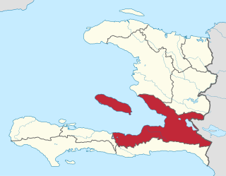
Ouest is one of the ten departments of Haiti. It is the jurisdictional seat of the national capital, the city of Port-au-Prince. It has an area of 4,982.56 square kilometres (1,923.78 sq mi) and a population of 4,029,705. It borders the Dominican Republic to the east.

Haiti country in the Caribbean

Haiti, officially the Republic of Haiti and formerly called Hayti, is a country located on the island of Hispaniola, east of Cuba in the Greater Antilles archipelago of the Caribbean Sea. It occupies the western three-eighths of the island, which it shares with the Dominican Republic. Haiti is 27,750 square kilometres (10,714 sq mi) in size and has an estimated 10.8 million people, making it the most populous country in the Caribbean Community (CARICOM) and the second-most populous country in the Caribbean as a whole.

The arondissement consists of the following communes:

Croix-des-Bouquets, Ouest Town in Ouest, Haiti

Croix-des-Bouquets is a town in the Croix-des-Bouquets commune in the Croix-des-Bouquets Arrondissement, in the Ouest department of Haiti. In 2009, the commune had 227,012 inhabitants, making it the most populous city in Ouest department outside of Port-au-Prince Arrondisement.

Thomazeau Commune in Ouest, Haiti

Thomazeau is a commune in the Croix-des-Bouquets Arrondissement, Ouest department of Haiti. It has 52,017 inhabitants.

Ganthier Commune in Ouest, Haiti

Ganthier is a commune in the Croix-des-Bouquets Arrondissement, in the Ouest department of Haiti. It has 71,261 inhabitants.

Related Research Articles

Anse d'Hainault is an arrondissement of the Grand'Anse Department located in southwestern Haiti. As of 2015, the population was 98,522 inhabitants. Postal codes in the Anse d'Hainault Arrondissement start with the number 72.

Corail is an arrondissement of the Grand'Anse department, located in southwestern Haiti. As of 2015, the population was 131,561 inhabitants. Postal codes in the Anse d'Hainault Arrondissement start with the number 73.

Fonds-Verrettes Commune in Ouest, Haiti

Fonds-Verrettes is a commune in the Croix-des-Bouquets Arrondissement, in the Ouest department of Haiti. It has 40,224 inhabitants.

Acul-du-Nord is an arrondissement of the Nord department of Haiti. As of 2015, the population was 129,155 inhabitants. Postal codes in the Acul-du-Nord Arrondissement start with the number 12.

Arcahaie is an arrondissement in the Ouest of Haiti. As of 2015, the population was 198,551 inhabitants. Postal codes in the Arcahaie Arrondissement start with the number 64.

Bainet is an arrondissement in the Sud-Est department of Haiti. As of 2015, the population was 135,792 inhabitants. Postal codes in the Bainet Arrondissement start with the number 92.

Belle-Anse is an arrondissement in the Sud-Est department of Haiti. As of 2015, the population was 158,081 inhabitants. Postal codes in the Belle-Anse Arrondissement start with the number 93.

Borgne is an arrondissement in the Nord department of Haiti. As of 2015, the population was 116,800 inhabitants. Postal codes in the Borgne Arrondissement start with the number 15.

Cap-Haïtien is an arrondissement in the Nord department of Haiti and is the second important city of the country. Known as the historical and touristic capital of the country. Cap-Haïtien was founded in 1670 by the French settler Bertrand d'Ogeron de La Bouëre. As of 2015, the population was 356,908 inhabitants. The city is governed by three mayors elected by popular vote every 5 years and also represented in the National Assembly of Haiti with one member elected every 4 years. Postal codes in Cap-Haïtien Arrondissement start with the number 11.

Grande-Rivière-du-Nord is an arrondissement in the Nord Department of Haiti. As of 2015, the population was 64,613 inhabitants. Postal codes in the Grande-Rivière-du-Nord Arrondissement start with the number 13.

Hinche is an arrondissement in the Centre department of Haiti. As of 2015, the population was 264,943 inhabitants. Postal codes in the Hinche Arrondissement start with the number 51.

Limbé is an arrondissement in the Nord department of Haiti. As of 2015, the population was 106,201 inhabitants. Postal codes in the Limbé Arrondissement start with the number 16.

Mirebalais is an arrondissement in the Centre department of Haiti. As of 2015, the population was 192,852 inhabitants. Postal codes in the Mirebalais Arrondissement start with the number 52.

Plaisance is an arrondissement in the Nord Department of Haiti. As of 2015, the population was 123,633 inhabitants. Postal codes in the Plaisance Arrondissement start with the number 17.

Port-au-Prince Arrondissement Arrondissement in Ouest, Haiti

Port-au-Prince is an arrondissement in the Ouest department of Haiti. It had 2,109,516 inhabitants at the 2003 Census which was estimated to have risen to 2,759,991 in 2015 in an area of 735.78 sq km. Postal codes in the Port-au-Prince Arrondissement start with the number 61.

Saint-Louis-du-Nord is an arrondissement in the Nord-Ouest department of Haiti. As of 2015, the population was 146,567 inhabitants. Postal codes in the Saint-Louis-du-Nord Arrondissement start with the number 32.

Trou-du-Nord is an arrondissement in the Nord-Est department of Haiti. As of 2015, the population was 115,000 inhabitants. Postal codes in the Trou-du-Nord Arrondissement start with the number 23.

References

  1. 1 2 3 "Population totale, population de 18 ans et plus ménages et densités estimés en 2015" [Total Population, Population of 18 and over, Households and Densities Estimated in 2015](PDF). IHSI (in French). March 2015. Archived from the original (PDF) on 2015-11-06. Retrieved 8 May 2017.

Coordinates: 18°34′34″N72°13′37″W / 18.5761°N 72.2269°W / 18.5761; -72.2269

Geographic coordinate system Coordinate system

A geographic coordinate system is a coordinate system that enables every location on Earth to be specified by a set of numbers, letters or symbols. The coordinates are often chosen such that one of the numbers represents a vertical position and two or three of the numbers represent a horizontal position; alternatively, a geographic position may be expressed in a combined three-dimensional Cartesian vector. A common choice of coordinates is latitude, longitude and elevation. To specify a location on a plane requires a map projection.