Anse d'Hainault is an arrondissement of the Grand'Anse Department located in southwestern Haiti. As of 2015, the population was 98,522 inhabitants. Postal codes in the Anse d'Hainault Arrondissement start with the number 72.
Corail is an arrondissement of the Grand'Anse department, located in southwestern Haiti. As of 2015, the population was 131,561 inhabitants. Postal codes in the Anse d'Hainault Arrondissement start with the number 73.
Jérémie is an arrondissement in the Grand'Anse Department of Haiti. As of 2015, the population was 238,218 inhabitants. Postal codes in the Anse d'Hainault Arrondissement start with the number 71.
Acul-du-Nord is an arrondissement of the Nord department of Haiti. As of 2015, the population was 129,155 inhabitants. Postal codes in the Acul-du-Nord Arrondissement start with the number 12.
Borgne is an arrondissement in the Nord department of Haiti. As of 2015, the population was 116,800 inhabitants. Postal codes in the Borgne Arrondissement start with the number 15.
Cap-Haïtien is an arrondissement in the Nord department of Haiti and is the second important city of the country. Known as the historical and touristic capital of the country. Cap-Haïtien was founded in 1670 by the French settler Bertrand d'Ogeron de La Bouëre. As of 2015, the population was 356,908 inhabitants. The city is governed by three mayors elected by popular vote every 5 years and also represented in the National Assembly of Haiti with one member elected every 4 years. Postal codes in Cap-Haïtien Arrondissement start with the number 11.
Cerca-la-Source is an arrondissement (district) in the Centre department of Haiti. As of 2015, the population was 119,756 inhabitants. Postal codes in the Cerca-la-Source Arrondissement start with the number 54.
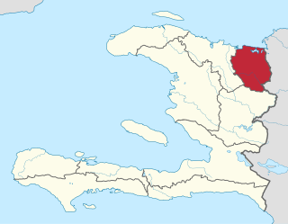
Fort-Liberté is an arrondissement in the Nord-Est department of Haiti. As of 2015, the population was 60,632 inhabitants. Postal codes in the Fort-Liberté Arrondissement start with the number 21.
Grande-Rivière-du-Nord is an arrondissement in the Nord Department of Haiti. As of 2015, the population was 64,613 inhabitants. Postal codes in the Grande-Rivière-du-Nord Arrondissement start with the number 13.
Hinche is an arrondissement in the Centre department of Haiti. As of 2015, the population was 264,943 inhabitants. Postal codes in the Hinche Arrondissement start with the number 51.
Lascahobas is an arrondissement in the Centre department of Haiti. As of 2015, the population was 168,685 inhabitants. Postal codes in the Lascahobas Arrondissement start with the number 53.
Limbé is an arrondissement in the Nord department of Haiti. As of 2015, the population was 106,201 inhabitants. Postal codes in the Limbé Arrondissement start with the number 16.
Môle-Saint-Nicolas is an arrondissement in the Nord-Ouest Department of Haiti. As of 2015, the population was 245,590 inhabitants. Postal codes in the Môle-Saint-Nicolas Arrondissement start with the number 33.
Plaisance is an arrondissement in the Nord Department of Haiti. As of 2015, the population was 123,633 inhabitants. Postal codes in the Plaisance Arrondissement start with the number 17.
Saint-Louis-du-Nord is an arrondissement in the Nord-Ouest department of Haiti. As of 2015, the population was 146,567 inhabitants. Postal codes in the Saint-Louis-du-Nord Arrondissement start with the number 32.
Trou-du-Nord is an arrondissement in the Nord-Est department of Haiti. As of 2015, the population was 115,000 inhabitants. Postal codes in the Trou-du-Nord Arrondissement start with the number 23.
Vallières is an arrondissement in the Nord-Est department of Haiti. As of 2015, the population was 71,851 inhabitants. Postal codes in the Vallières Arrondissement start with the number 24.

Baptiste is a commune in the Lascahobas Arrondissement, in the Centre department of Haiti. The town was made a commune by presidential decree on 22 July 2015 made it a commune.