Crows Nest, New South Wales

Last updated

Crows Nest
Sydney,  New South Wales
Crows Nest Community Centre.JPG
Crows Nest Centre
Crows Nest, New South Wales
Population4,974 (2021 census) [1]
 • Density6,540/km2 (16,950/sq mi)
Postcode(s) 2065
Elevation93 m (305 ft)
Area0.76 km2 (0.3 sq mi)
Location5 km (3 mi) N of Sydney CBD
LGA(s) North Sydney Council
State electorate(s) Willoughby
Federal division(s) North Sydney
Suburbs around Crows Nest:
Willoughby Naremburn Cammeray
St Leonards Crows Nest Cammeray
Wollstonecraft Waverton North Sydney

Crows Nest is a suburb on the lower North Shore of Sydney, New South Wales, Australia. It is also part of the North Sydney region, 5 kilometres north of the Sydney central business district, in the local government area of North Sydney Council.

Contents

History

Crows Nest was originally part of a 524-acre (2.12 km2) land grant made to Edward Wollstonecraft in 1821. [2] The grant extended from the site of the present day Crows Nest to Wollstonecraft. Edward Wollstonecraft built a cottage, the 'Crow's Nest' and, according to his business partner Alexander Berry, chose the name "on account of its elevated and commanding position". [3] Berry later built a more substantial Crow's Nest House on the estate in 1850, taking the name of the earlier cottage. [4] This site is now the site of North Sydney Demonstration School. The gates of Crows Nest House (added in the 1880s) still stand at the Pacific Highway entrance to the school. Berry died at Crows Nest House on 30 November 1873. [5]

Heritage listings

Crows Nest has some heritage-listed sites, including:

St Thomas Rest Park

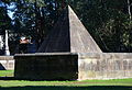
St Thomas Rest Park, located in West Street, was originally the cemetery of St Thomas's Church. It was the first burial ground established on Sydney's north shore. The land for the cemetery was donated to the Anglican Parish of St Leonards in 1845 by the prominent landowner and merchant, Alexander Berry. Notable people buried there include Alexander Berry and George Barney. Alexander Berry was buried there with his wife, in 1873, when he died at the age of 92. They are interred in an unusual, pyramid-shaped tomb with his wife's brother, Edward Wollstonecraft, former owner of Crows Nest Farm, after which the area is named. George Barney (lieutenant colonel) was born in London in 1792, and arrived in Sydney in 1835. He held a number of posts, including Commander of the Royal Engineers, and he designed Victoria Barracks. He was responsible for the completion of Fort Denison, Circular Quay, Cockatoo Dock and Darlinghurst Gaol.

The park includes the original Sexton's Cottage, which is now used as a museum of local history, and is heritage-listed. [7]

Population

At the 2021 census, there were 4,974 residents in Crows Nest. 57.0% of residents were born in Australia. The other most common countries of birth were England 5.6%, New Zealand 3.2%, China 3.1%, India 2.3% and Japan 1.8%. 71.5% of people only spoke English at home. Other languages spoken at home included Mandarin 3.9%, Cantonese 2.9%, Japanese 2.1%, Spanish 1.8% and French 1.3%. The most common responses for religious affiliation were No Religion 49.7% and Catholic 20.7%, Anglican 8.0%, 5.1% of residents did not state their religion, and 2.9% practised Buddhism.

The median age recorded at the 2021 census was 36. 36.0% of people were in the 25-39 year age group, compared to 21.5% nationally. The most common ancestries were English 32.9%, Australian 24.5%, Irish 12.5%, Chinese 10.9% and Scottish 10.4%. [1]

Commercial area

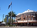
Crows Nest is a significant commercial district which is noted for its variety of shops and restaurants. It is centred on the junction of five main roads about 1 kilometre north by northwest of the original site of Crows Nest House.

Transport

The Warringah Freeway runs along the northern border of Crows Nest and the Pacific Highway is a major road along the western border. Crows Nest railway station is a Sydney Metro station part of the Sydney Metro City & Southwest line, opened 19 August, 2024. [8]

Schools and colleges

Churches

Related Research Articles

<span class="mw-page-title-main">Alexander Berry</span> Australian politician (1781–1873)

Alexander Berry was a Scottish-born surgeon, merchant and explorer who was given in 1822 a land grant of 10,000 acres (40 km2) and 100 convicts to establish the first European settlement on the south coast of New South Wales, Australia.

Berry is a small Australian village in the Shoalhaven region of the New South Wales South Coast, located 143 km (89 mi) south of the state capital, Sydney. It has many historical buildings which are listed on the New South Wales Heritage Register. Berry attracts many tourists who come to enjoy the diversity of landscapes, including coastal beaches, rich dairy farming, and forested mountains. The village hosts a local Produce Market which is held twice each month on the second Saturday and fourth Sunday. Together with Kiama 23 km (14 mi) to the north, Berry acts as a gateway through to other towns and villages along the South Coast of NSW via the Princes Highway and the South Coast railway line. Major highway building projects in and around Berry have now bypassed the village, creating uninterrupted motorway conditions for coastal travel south to Nowra and the South Coast and north to Wollongong and Sydney. This has resulted in the removal of all but local and visitor traffic within the village. Planning is underway to create a pedestrian-friendly precinct in and around Queens Street.

<span class="mw-page-title-main">Gordon, New South Wales</span> Suburb of Sydney, New South Wales, Australia

Gordon is a suburb on the Upper North Shore of Sydney in the state of New South Wales, Australia 14 kilometres (9 mi) north-west of the Sydney Central Business District and is the administrative centre for the local government area of Ku-ring-gai Council. East Gordon is a locality within Gordon, and West Gordon is a locality within West Pymble.

<span class="mw-page-title-main">North Shore (Sydney)</span> Region in New South Wales, Australia

The North Shore is a region within Northern Sydney, in New South Wales, Australia, generally referring to suburbs located on the northern side of Sydney Harbour up to Wahroonga, and suburbs between Middle Harbour and the Lane Cove River.

<span class="mw-page-title-main">St Leonards, New South Wales</span> Suburb of Sydney, New South Wales

St Leonards is a suburb on the lower North Shore of Sydney, Australia. St Leonards is located 5 km (3.1 mi) north-west of the Sydney central business district and lies across the local government areas of Municipality of Lane Cove, North Sydney Council and the City of Willoughby.

<span class="mw-page-title-main">Chatswood, New South Wales</span> Suburb of Sydney, New South Wales, Australia

Chatswood is a suburb in the Lower North Shore of Sydney, in the state of New South Wales, Australia, 10 kilometres north of the Sydney central business district. It is the administrative centre of the local government area of the City of Willoughby.

<span class="mw-page-title-main">North Sydney, New South Wales</span> Suburb of Sydney, New South Wales, Australia

North Sydney is a suburb and major commercial district on the Lower North Shore of Sydney, New South Wales, Australia. It is located three kilometres north of the Sydney central business district and is the administrative centre for the local government area of North Sydney Council.

<span class="mw-page-title-main">Burwood, New South Wales</span> Suburb of Sydney, New South Wales, Australia

Burwood is a suburb in the Inner West of Sydney, in the state of New South Wales, Australia. It is 10 kilometres (6.2 mi) west of the Sydney central business district and is the administrative centre for the local government area of Municipality of Burwood.

<span class="mw-page-title-main">Artarmon, New South Wales</span> Suburb of Sydney, New South Wales

Artarmon is a suburb on the lower North Shore of Sydney, in the state of New South Wales, Australia, 9 kilometres north-west of the Sydney central business district, in the local government area of the City of Willoughby.

Edward Wollstonecraft was a successful businessman in early colonial Australia, settling in what is now Sydney. He was the nephew of the early feminist Mary Wollstonecraft and cousin to Mary Wollstonecraft Shelley, the author of Frankenstein.

<span class="mw-page-title-main">North Sydney Council</span> Local government area in New South Wales, Australia

North Sydney Council is a local government area on the Lower North Shore of Sydney, New South Wales, Australia, established on 29 July 1890 through the amalgamation of three boroughs.

<span class="mw-page-title-main">Willoughby, New South Wales</span> Suburb of Sydney, New South Wales, Australia

Willoughby is a suburb located on the lower North Shore of Sydney, in the state of New South Wales, Australia 8 kilometres north of the Sydney central business district, in the local government area of the City of Willoughby.

<span class="mw-page-title-main">Belmore, New South Wales</span> Suburb of Sydney, New South Wales, Australia

Belmore is a suburb of Sydney, in the state of New South Wales, Australia. Belmore is located 11 kilometres south-west of the Sydney central business district, in the local government area of the City of Canterbury-Bankstown.

<span class="mw-page-title-main">Harris Park, New South Wales</span> Suburb of Greater Western Sydney, New South Wales, Australia

Harris Park is a suburb of Greater Western Sydney, in the state of New South Wales, Australia. Harris Park is located 19 kilometres west of the Sydney central business district in the local government area of the City of Parramatta and is part of the Greater Western Sydney region. Harris Park has a plurality of Indian and Hindu population, both making up the largest ethnic and religious group.

<span class="mw-page-title-main">St Thomas' Anglican Church, North Sydney</span> Church in New South Wales, Australia

St Thomas' Anglican Church, North Sydney is a large Anglican church in Sydney's North Shore. It is located at the corner of Church and McLaren streets, close to the North Sydney central business district. The church is listed on the local government heritage register and is listed on the Register of the National Estate.

<span class="mw-page-title-main">Berry Island, New South Wales</span> Place in New South Wales, Australia

Berry Island is a locality in Wollstonecraft on the lower North Shore of Sydney, New South Wales, Australia. It was originally one of Sydney's Harbour Islands, but it is now connected to the mainland by a constructed isthmus.

<span class="mw-page-title-main">St Thomas Rest Park</span> Cemetery in North Shore, Sydney, Australia

St Thomas Rest Park, located in West Street, Crows Nest, New South Wales is the site of the first cemetery on Sydney's North Shore. It is the largest park in the densely populated Crows Nest area.

<span class="mw-page-title-main">Cammeraygal High School</span> School in Australia

Cammeraygal High School is a government-funded co-educational comprehensive secondary day school, located on the Pacific Highway, Crows Nest, a suburb on the lower north shore of Sydney, New South Wales, Australia.

<i>Don Bank</i> Historic site in New South Wales, Australia

Don Bank is a heritage-listed former residence and now house museum at 6 Napier Street, North Sydney, New South Wales, Australia. It was built from 1853 to 1858 for Edward Wollstonecraft. It is also known as St. Leonard's Cottage. The property is owned by North Sydney Council. It was added to the New South Wales State Heritage Register on 2 April 1999.

The Mater Hospital is a 233-bed private hospital located in North Sydney, New South Wales, Australia. Originally founded in 1906 as a cottage hospital, and operated both as a public hospital and maternity hospital on an adjacent site in Wollstonecraft, New South Wales, between 1940 and 1982, the current hospital opened in 1990 and is now operated by St Vincent's Health.

References

  1. 1 2 Australian Bureau of Statistics (28 June 2022). "Crows Nest". 2021 Census QuickStats. Retrieved 6 February 2024. OOjs UI icon edit-ltr-progressive.svg
  2. State Library of New South Wales (1993), Guide to the papers of the Berry, Wollstonecraft and Hay Families (PDF), retrieved 20 October 2009
  3. Alexander, Berry (1912). Reminiscences. Angus & Robertson, Sydney. p. 172.
  4. Placenames Australia (March 2007). "Placenames from house names in Sydney suburbs" (PDF). Newsletter of the Australian National Placenames Survey: 5. Archived from the original (PDF) on 18 February 2011. Retrieved 27 October 2009.
  5. The Book of Sydney Suburbs, Compiled by Frances Pollen, Angus & Robertson Publishers, 1990, Published in Australia ISBN   0-207-14495-8
  6. "Electricity Power House". New South Wales State Heritage Register . Department of Planning & Environment. H00931. Retrieved 18 May 2018. CC BY icon.svg Text is licensed by State of New South Wales (Department of Planning and Environment) under CC-BY 4.0 licence .
  7. State Heritage Register
  8. "Sydney Metro promises to reshape the city. Here's how it'll affect you". ABC News. 18 August 2024. Retrieved 9 September 2024.
  9. St Michael Greek Orthodox Church Archived 27 August 2015 at the Wayback Machine

33°49′34″S151°12′18″E / 33.82613°S 151.20505°E / -33.82613; 151.20505