
Croydon is a large town in South London, England, 9.3 miles (15.0 km) south of Charing Cross. Part of the London Borough of Croydon, a local government district of Greater London, it is one of the largest commercial districts in Greater London, with an extensive shopping district. The entire town had a population of 192,064 as of 2011, whilst the wider borough had a population of 384,837.

East Croydon is a railway station, tram stop and associated bus station in Croydon, Greater London, England. It is located in Travelcard Zone 5. At 10 miles 28 chains from London Bridge, it is the 20th busiest station in Britain, was the 10th busiest in 2020–21, is the busiest national rail station in London outside of fare zones 1 and 2 and is one of the busiest non-terminal stations in the country. It is one of three railway stations in the London Borough of Croydon with Croydon in their name, the others being West Croydon and South Croydon. A Tramlink tram stop is located immediately outside the main station entrance.
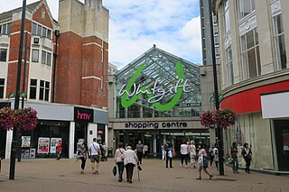
The Whitgift Centre is a large shopping centre in the town centre of Croydon, opening in stages between 1968 and 1970. The centre comprises 1,302,444 sq ft (121,001 m2) of retail space, and was the largest covered shopping development in Greater London until the opening of Westfield London at White City in 2008. The Whitgift Centre has a monthly footfall of 2.08 million. The complex includes an office development.

The documented history of Islam in the Republic of Ireland dates back to the 1950s. The number of Muslims in the Republic of Ireland has increased since the 1990s, mostly through immigration. For the 2022 Irish census, 81,930 were counted.

Islam constitutes the third largest religion in Singapore, with Muslims accounting for approximately 15.6% of the population, as indicated by the 2020 census. Predominantly, Singaporean Muslims are Sunni Muslims adhering to either the Shafi‘i or Hanafi schools of thought. The majority of the Muslim population, about 80%, are ethnic Malays, while 13% are of Indian descent. The remaining fraction comprises local Chinese, Eurasian, and Arab communities, in addition to foreign migrants. Buddhism and Christianity are the two larger religious affiliations in the country.

The Big City Plan is a major development plan for the city centre of Birmingham, England.
The Majlis Ugama Islam Singapura (MUIS), also known as the Islamic Religious Council of Singapore (IRCS), is a statutory board of the Ministry of Culture, Community and Youth of the Government of Singapore. As a majlis, its role is to look after the administration and interests of Singapore's Muslim community. The Majlis is headed by a Council, in which members are appointed by the President of Singapore. Since 2009, the council is headquartered in the Singapore Islamic Hub, along Braddell Road.

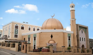
The Baitul Futuh is a mosque complex of the Ahmadiyya Muslim Community, situated in Morden, London. It is one of the largest mosque complexes in Europe. Completed in 2003 at a cost of £15 million, entirely from donations of Ahmadi Muslims, the Mosque can accommodate a total of 13,000 worshippers. The main mosque has a height of 23m above ground, and to maximise capacity the building extends below ground. Baitul Futuh is located in the south-west London suburb London Borough of Merton. It is situated next to Morden South railway station, 0.4 miles from Morden Underground station and one mile from Morden Road tram stop.
Eswatini is a Christian majority country, with adherents of Islam being a minority. Due to the secular nature of Eswatini's constitution, Muslims are free to proselytize and build places of worship in the country.
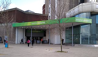
Lewisham Shopping Centre, formerly Riverdale Centre, is a shopping mall located in Lewisham, London, England. The centre is the major shopping centre in the London Borough of Lewisham. Also part of the complex is the Lewisham House office tower, formerly occupied by Citibank. There are proposals to convert this building to flats.

The East London Mosque (ELM) is situated in the London Borough of Tower Hamlets between Whitechapel and Aldgate East. Combined with the adjoining London Muslim Centre and Maryam Centre, it is one of the largest mosques in Western Europe accommodating more than 7,000 worshippers for congregational prayers. The mosque was one of the first in the UK to be allowed to use loudspeakers to broadcast the adhan.
There were 1,318,755 Muslims reported in the 2021 census in the Greater London area. In the 2021 census Office for National Statistics, the proportion of Muslims in London had risen to 15% of the population, making Islam the second largest religion in the city after Christianity.
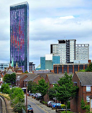
Saffron Square is a town square and high-rise building in Croydon, United Kingdom. The purple and red Saffron Tower is currently the second-tallest building in Croydon.
The En-Naeem Mosque is a mosque located at the junction of Hougang Avenue 3 and Tampines Road, in Hougang, Singapore. It is built under the Mosque Building Fund (MBF) by MUIS Mosque Management.
The Haji Yusoff Mosque is a mosque located in Hillside Drive, off Upper Serangoon Road, Singapore. It is a Wakaf type of mosque.
Blackpool Central Mosque and Islamic Community Centre is a Sunni mosque in Blackpool, Lancashire, England.

The Suleymaniye Mosque is a mosque on Kingsland Road in Haggerston, London, United Kingdom, which serves the entire Muslim community as well as the Turkish speaking community. The mosque was funded by the UK Turkish Islamic Cultural Centre (UKTICC) and the construction began in 1994 and was finally opened to the public in October 1999. With a total floor space of 8,000 square metres, the total capacity of its Ottoman style mosque is 3,000 people.

The Wembley Central Mosque is a mosque in the London Borough of Brent. The principal mosque in North West London, it is located on Ealing Road, Wembley, and serves the United Kingdom’s fifth largest Muslim community, which is predominantly Pakistani and Bangladeshi. Along with the adjacent Muslim Welfare Association, it can hold up to 2200 people.
Wightman Road Masjid is a Sunni mosque and Islamic community centre in Hornsey, London. It is Haringey's first purpose-built Mosque. The masjid regularly hosts interfaith events and school visits. The Mosque was also the first to hold a pop-up vaccine centre in Haringey to encourage those reluctant to be vaccinated to come forward.
