
Tropical cyclones and subtropical cyclones are named by various warning centers to simplify communication between forecasters and the general public regarding forecasts, watches and warnings. The names are intended to reduce confusion in the event of concurrent storms in the same basin. Once storms develop sustained wind speeds of more than 33 knots, names are generally assigned to them from predetermined lists, depending on the basin in which they originate. Some tropical depressions are named in the Western Pacific, while tropical cyclones must contain a significant amount of gale-force winds before they are named in the Southern Hemisphere.

Meteorology, Climatology, and Geophysical Agency is an Indonesian non-departmental government agency for meteorology, climatology, and geophysics.

The 2008–09 Australian region cyclone season was a near average tropical cyclone season. It officially started on 1 November 2008, and officially ended on 30 April 2009. This season was also the first time that the BoM implemented a "tropical cyclone year." The regional tropical cyclone operational plan defines a "tropical cyclone year" separately from a "tropical cyclone season"; the "tropical cyclone year" began on 1 July 2008 and ended on 30 June 2009.
The 2011–12 Australian region cyclone season was a below average tropical cyclone season, with 7 cyclones forming rather than the usual 11. It began on 1 November 2011, and ended on 14 May 2012. The regional tropical cyclone operational plan defines a "tropical cyclone year" separately from a "tropical cyclone season"; the "tropical cyclone year" began on 1 July 2011 and ended on 30 June 2012.
The 2010 Papua earthquake occurred on June 16 at 12:16 local time in Papua province of Indonesia. The magnitude 7.0 mainshock was preceded by an 6.2 foreshock 10 minutes earlier, and was followed 42 minutes later by an Mw 6.6 aftershock.

In late October 2010, Mount Merapi in border of Central Java and Special Region of Yogyakarta, Indonesia began an increasingly violent series of eruptions that continued into November. Seismic activity around the volcano increased from mid-September onwards, culminating in repeated outbursts of lava and volcanic ash. Large eruption columns formed, causing numerous pyroclastic flows down the heavily populated slopes of the volcano. The 2010 eruption of Merapi was the volcano's largest since 1872.
The 2004–05 Australian region cyclone season was a near-average season with eleven tropical cyclones occurring within the Australian region south of the equator and from 90°E to 160°E. The season officially ran from 1 November 2004 to 30 April 2005 with pre-season Tropical Cyclone Phoebe forming on 1 September and an unnamed tropical cyclone dissipating on 15 April. This is the period of the year when most tropical cyclones form within the Australian region.

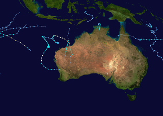
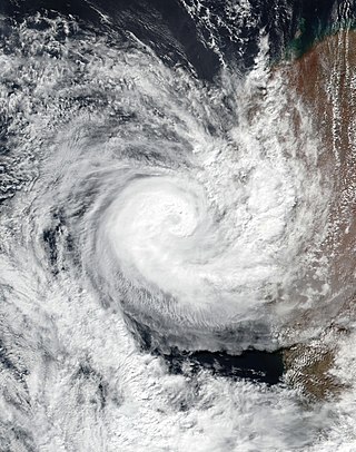
Throughout 2006, 133 tropical cyclones formed in seven bodies of water known as tropical cyclone basins. Of these, 80 have been named, including two tropical cyclones in the South Atlantic Ocean, and a tropical cyclone in the Mediterranean Sea, by various weather agencies when they attained maximum sustained winds of 65 km/h (40 mph). The strongest storms of the year were Typhoon Yagi in the Western Pacific, and Cyclone Glenda of the Australian region. The deadliest and costliest storms of the year were a series of five typhoons that struck the Philippines and China; Chanchu, Bilis, Saomai, Xangsane, and Durian, with most of the damage being caused by Durian of November. So far, 27 Category 3 tropical cyclones formed, including five Category 5 tropical cyclones in the year. The accumulated cyclone energy (ACE) index for the 2006, as calculated by Colorado State University was 761 units.

The 2016–17 Australian region cyclone season, despite a very high number of tropical lows, was a slightly below-average season in terms of activity, with nine tropical cyclones, three of which intensified further into severe tropical cyclones; though it was much more active than the previous season. The season was the first to have a severe tropical cyclone since the 2014–15 season. It was the period of the year when most tropical cyclones form in the Southern Indian Ocean and Pacific Oceans between 90°E and 160°E. The season officially ran from 1 November 2016 to 30 April 2017, however, a tropical cyclone could form at any time between 1 July 2016 and 30 June 2017 and would count towards the season total. The first named storm, Yvette, developed during 21 December, and the final named storm, Greg, left the region on 3 May as a remnant low. This season was also the second-costliest tropical cyclone season on record in the Australian region basin, behind only the 2010–11 season, with a total of AUD$3.7 billion in damages incurred by the various storms, mostly from Cyclone Debbie.

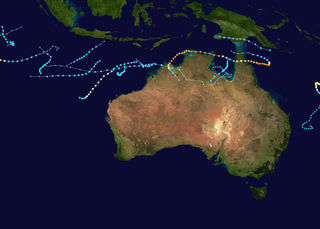
The 2017–18 Australian region cyclone season was an average period of tropical cyclone formation in the Southern Indian Ocean and South Pacific Ocean, between 90°E and 160°E, with 11 named storms, which 3 intensified into severe tropical cyclones. Another two tropical cyclones, Cempaka and Flamboyan occurred outside the Australian region but are included in the descriptions below. The season officially began 1 November 2017 and ended on 30 April 2018; however, tropical cyclones can form at any time of the year, as demonstrated by the first tropical low of the season in early August. Any tropical system that forms between 1 July 2017 and 30 June 2018 will count towards the season total. During the season, tropical cyclones will be officially monitored by one of the five tropical cyclone warning centres (TCWCs) that operate in this region. Three of the five centres are operated by the Australian Bureau of Meteorology (BOM) in Perth, Darwin and Brisbane, while the other two are operated by the National Weather Service of Papua New Guinea in Port Moresby and the Indonesian Agency for Meteorology, Climatology and Geophysics in Jakarta. The Joint Typhoon Warning Center (JTWC) of the United States and other national meteorological services, including Météo-France at Réunion, also monitored the basin during the season.

The 2018–19 Australian region cyclone season was an average season that saw the formation of 11 tropical cyclones, six of which intensified further to become severe tropical cyclones. The season officially began on 1 November 2018 and concluded on 30 April 2019; however, as evidenced by Tropical Low Liua in September 2018 and Tropical Cyclones Lili and Ann in May 2019, tropical cyclones can form at any time of the year. As such, any system existing between 1 July 2018 and 30 June 2019 would count towards the season total. During the season, tropical cyclones were officially monitored by the Bureau of Meteorology (BOM), the Indonesian Agency for Meteorology, Climatology and Geophysics (BMKG) in Jakarta, Indonesia, and the National Weather Service of Papua New Guinea in Port Moresby. The United States' Joint Typhoon Warning Center (JTWC) in Hawaii, and other national meteorological services such as MetService in New Zealand, Météo-France at La Réunion, and the Fiji Meteorological Service (FMS), also monitored parts of the basin during the season in an unofficial capacity.
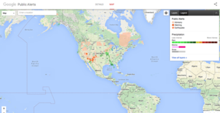
Google Public Alerts Site was an online notification service owned by Google.org that sends safety alerts and launched to the United States, Australia, Canada, Colombia, Japan, Taiwan, Indonesia, Mexico, and Brazil on October 30, 2012, and to the Philippines on November 12, 2014. It is part of the Google Crisis Response team and publishes content from its partners of each country. If you activate Google Now, you can see suitable weather and public safety on Google Search and Google Maps.
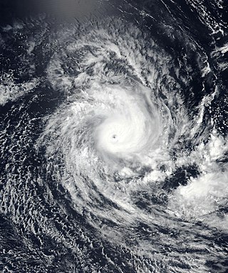
Severe Tropical Cyclone Savannah was a strong tropical cyclone that brought significant impacts to Java and Bali and minor impacts to Christmas Island and the Cocos (Keeling) Islands during March 2019. It was the sixteenth tropical low, sixth tropical cyclone and third severe tropical cyclone of the 2018–19 Australian region cyclone season. Savannah developed from a tropical low that formed well to the east of Christmas Island on 8 March. The system was slow to develop initially, but reached tropical cyclone intensity on 13 March after adopting a southwesterly track. Savannah underwent rapid intensification and reached peak intensity on 17 March as a Category 4 severe tropical cyclone on the Australian scale. Ten-minute sustained winds were estimated as 175 kilometres per hour (109 mph), with a central barometric pressure of 951 hPa (28.08 inHg). One-minute sustained winds reached 185 kilometres per hour (115 mph) at this time, equivalent to a Category 3 major hurricane on the Saffir–Simpson hurricane wind scale. Weakening commenced soon afterwards, and responsibility for the system passed from the Australian Bureau of Meteorology to Météo-France. As it moved into the new region, Savannah became the eighth of a record-breaking ten intense tropical cyclones in the 2018–19 South-West Indian Ocean cyclone season. Savannah was downgraded to a tropical depression on 20 March, and its remnants dissipated in the central Indian Ocean on 24 March.

The 1973 Flores cyclone was the deadliest known tropical cyclone in the Southern Hemisphere, having killed 1,653 people in Indonesia in April 1973. The cyclone formed in the Banda Sea on 26 April as a tropical low. It intensified as it moved in a west-southwest direction, before shifting to the south. On 29 April, the cyclone struck the north coast of the island of Flores, dissipating the next day. The cyclone killed 1,500 people on Palu'e island. The cyclone dropped heavy rainfall across Flores, causing deadly flash flooding that damaged buildings and roads, destroying or damaging thousands of houses.

The year 1992 featured the highest amount of accumulated cyclone energy (ACE) on record, with an ACE rating of 1,163.1 units. It would be regarded as one of the most intense tropical cyclone years on record. Throughout the year, 111 tropical cyclones formed, of which 101 were given names by various weather agencies. Five Category 5 tropical cyclones would form in 1992.
Indonesia is an island country in Southeast Asia and Oceania, located in the Pacific Ocean and the Indian Ocean. The largest island nation in the world, the country is the home of over seventeen thousand islands.
Severe Tropical Cyclone Seroja was the third-deadliest tropical cyclone on record in the Australian region, behind Cyclone Mahina in 1899 and the Flores cyclone in 1973. Seroja brought historic flooding and landslides to portions of southern Indonesia and East Timor and later went on to make landfall in Western Australia's Mid West region, becoming the first to do so since Cyclone Elaine in 1999. The twenty-second tropical low, seventh tropical cyclone, and third severe tropical cyclone of the 2020–21 Australian region cyclone season, the precursor of Seroja formed off the south coast of Timor island as Tropical Low 22U at 18:00 UTC on 3 April 2021; its genesis was related to convectively coupled equatorial waves. The tropical low moved very slowly near the island, while the system's thunderstorms increased in organization. The low intensified into Tropical Cyclone Seroja by 4 April, while it was passing north of Rote Island, while continuing its slow strengthening trend.
Jagoi Babang is a district in Bengkayang Regency, West Kalimantan, Indonesia. This area is located on the border of West Kalimantan with Sarawak, Malaysia.

Tropical Cyclone Robyn was a deadly and erratic tropical cyclone that contributed towards heavy rains and flooding throughout the Indonesian islands of Sumatra and Java in November 2024. Robyn was the first tropical system to form during the 2024–25 Australian region cyclone season.


