Dalton Township, Wayne County, Indiana

Last updated

Dalton Township
Map highlighting Dalton Township, Wayne County, Indiana.svg
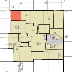
Location in Wayne County
Coordinates: 39°58′40″N85°09′33″W / 39.97778°N 85.15917°W / 39.97778; -85.15917
Country United States
State Indiana
County Wayne
Government
  Type Indiana township
Area
  Total
15.79 sq mi (40.9 km2)
  Land15.75 sq mi (40.8 km2)
  Water0.04 sq mi (0.10 km2)  0.25%
Elevation
[1]
1,180 ft (360 m)
Population
 (2020) [2]
  Total
633
  Density35.9/sq mi (13.9/km2)
Time zone UTC-5 (Eastern (EST))
  Summer (DST) UTC-4 (EDT)
Area code 765
GNIS feature ID 453252

Dalton Township is one of fifteen townships in Wayne County, Indiana, United States. As of the 2010 census, its population was 566 and it contained 239 housing units. [3]

Contents

History

Dalton Township was organized in 1847. [4]

Geography

According to the 2010 census, the township has a total area of 15.79 square miles (40.9 km2), of which 15.75 square miles (40.8 km2) (or 99.75%) is land and 0.04 square miles (0.10 km2) (or 0.25%) is water. [3] The streams of Corey Run, Flight Run, Franklin Run, Little Creek, Little Four Mile Creek, Mono Run, Propeller Run, Show Run, Single Run, West River and Wing Branch run through this township.

Unincorporated towns

(This list is based on USGS data and may include former settlements.)

Adjacent townships

Major highways

References

  1. "US Board on Geographic Names". United States Geological Survey. October 25, 2007. Retrieved May 9, 2017.
  2. "Census Bureau profile: Dalton Township, Wayne County, Indiana". United States Census Bureau. May 2023. Retrieved March 24, 2024.
  3. 1 2 "Population, Housing Units, Area, and Density: 2010 - County -- County Subdivision and Place -- 2010 Census Summary File 1". United States Census. Archived from the original on February 12, 2020. Retrieved May 10, 2013.
  4. Young, Andrew White (1872). History of Wayne County, Indiana, from Its First Settlement to the Present Time. R. Clarke & Company. pp.  204.