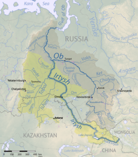
The Irtysh River is a river in Russia, China, and Kazakhstan. It is the chief tributary of the Ob River.
The Dafo Temple is a famous Buddhist temple in Zhejiang and has a long history of more than 1600 years. This Temple is the symbol of the Xinchang prefecture and it attracts tens of thousands of visitors every year. Recently, the temple and its surroundings have been used as a location for movies and filming, because of its natural environment.

The Hongshui River is a major river in the Guangxi Zhuang Autonomous Region in Southern China. It is one of the main rivers in the basin of the Xi River, which in its turn is one of the main tributaries of the Pearl River.

This is a list of the extreme points of the Czech Republic: the points that are farther north, south, east or west than any other location.

Bieżuń is a town in Żuromin County, Masovian Voivodeship, Poland, with 1,903 inhabitants (2004) on the Wkra River. Jedrzej of Golczew, castellan of Płock, established the town at the end of the 14th century. Prince Siemowit IV, Duke of Masovia granted the city rights charter in 1406 and in 1869, during Russia's occupation, the town lost its city rights until 1994. Prior to the Deluge the town was famous and had a strong castle, but it was destroyed during that war. Polish Crown Kanclerz Andrzej Zamoyski was born there and lived in the palace he built while working on his code of civil laws known as Zbiór praw sądowych During Zamojski's residency there, in 1767, Polish-Lithuanian Commonwealth king Stanisław August Poniatowski granted the renewal of the town charter under the Magdeburg rights. After the Third of Partitions of Poland town fell into the Prussia's domain, then during the War of the Fourth Coalition there was a small pitched battled between the Napoleonic troops and the Prussians known as Combat of Bieżuń(2), it was a French victory and took place on December 21–23, 1806. Between 1807-15 it was part of Duchy of Warsaw, then under the Russian dominion until 1918.
Ankara River, is a small river that runs through the city of Ankara, Turkey. Because of long time exposure to sewage and industrial pollutants, it is no longer viable as a water source for irrigation even though it is still used for irrigation down stream, and causes cholera and other diseases in the city. During hot days, the smell of sewage from the river makes this environmental disaster even more obvious. There are World Bank funded projects to clean it up.

Cornwallis Square is a Canadian village in Kings County, Nova Scotia. It is located on the Cornwallis River.
The Honnuhole River is a tributary of the Kaveri River in Karnataka, India. It arises south of Kollegal near the town of Yelandur and flows into the Kaveri just northwest of the town of Kollegal.
Szlasy-Łopienite is a village in the administrative district of Gmina Rutki, within Zambrów County, Podlaskie Voivodeship, in north-eastern Poland.

Dəmirçidam is a village in the Kalbajar Rayon of Azerbaijan.

Jabłonna is a village in the administrative district of Gmina Przedbórz, within Radomsko County, Łódź Voivodeship, in central Poland. It lies approximately 2 kilometres (1 mi) south of Przedbórz, 31 km (19 mi) east of Radomsko, and 85 km (53 mi) south of the regional capital Łódź.

Baihe is located in the southeastern portion of Shaanxi province, China and is the easternmost county-level division under the jurisdiction of the prefecture-level city of Ankang. It is by the eastern part of the Daba Mountains and approaches the Han River on the north. On the east it borders Yun County (Hubei), on the south Zhushan County (Hubei), on the west Xunyang County, and is separated from Yunxi County (Hubei) by a river.
Płocicz is a village in the administrative district of Gmina Koczała, within Człuchów County, Pomeranian Voivodeship, in northern Poland. It lies approximately 5 kilometres (3 mi) south of Koczała, 31 km (19 mi) north-west of Człuchów, and 117 km (73 mi) south-west of the regional capital Gdańsk.

Bằng Vân is a commune (xã) and village in Ngân Sơn District, Bắc Kạn Province, in Vietnam.
The Muddy River is a 4.7-mile-long (7.6 km) river in Topsham, Maine, which empties into Merrymeeting Bay. The river is also known to be very muddy.

Rajno Polje is a village in the municipality of Leskovac, Serbia. According to the 2002 census, the village has a population of 739 people.
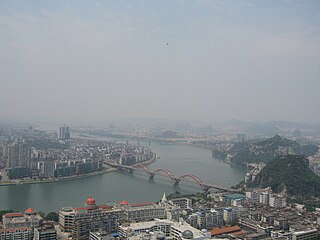
The Liu River is a tributary within the Pearl River system in Guangxi, China. It is formed by the confluence of the Rong and Long rivers in Fengshan. It flows south through Liuzhou and is joined by the Luoqing Jiang to the south. It meets the larger Hongshui He east of Laibin where it becomes known as the Qian Jiang.
Paunaste is a village in Kose Parish, Harju County in northern Estonia.

Cottonwood is a census-designated place (CDP) in Apache County, Arizona, United States. The population was 226 at the 2010 census.