| Darley Mountain | |
|---|---|
 Southwest aspect | |
| Highest point | |
| Elevation | 13,260 ft (4,042 m) [1] |
| Prominence | 480 ft (150 m) [2] |
| Parent peak | Wildhorse Peak (13,266 ft) [3] |
| Isolation | 2.19 mi (3.52 km) [3] |
| Coordinates | 37°58′58″N107°35′17″W / 37.9827669°N 107.5881045°W [4] |
| Naming | |
| Etymology | George M. Darley |
| Geography | |
 Darley Mountain Location in Colorado  Darley Mountain Darley Mountain (the United States) | |
| Location | Hinsdale County / Ouray County Colorado, US |
| Parent range | Rocky Mountains San Juan Mountains |
| Topo map | USGS Handies Peak |
| Climbing | |
| Easiest route | class 2 hiking [3] |
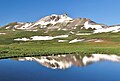
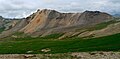
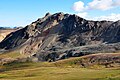
Darley Mountain is a 13,260-foot-elevation (4,040-meter) mountain summit located on the shared boundary of Hinsdale County with Ouray County, in southwest Colorado, United States. [4] It is situated five miles southeast of the community of Ouray, in the Uncompahgre Wilderness, on land managed by Uncompahgre National Forest. It is part of the San Juan Mountains which are a subset of the Rocky Mountains, and is west of the Continental Divide. Neighboring geographic features include Engineer Pass 0.6 mile to the southeast, Engineer Mountain 0.9 mile to the south, and nearest higher neighbor Wildhorse Peak 2.2 miles to the north. [2] The mountain's name was officially adopted in 1992 by the United States Board on Geographic Names to commemorate George Marshall Darley (1847–1917), pioneering minister of the San Juan Mountains, who founded and built the first church in western Colorado in Lake City in 1876. [1] Lake City is approximately 16 miles east of this mountain.