Delgado, El Salvador

Last updated
Ciudad Delgado
Municipality
Delgado, San Salvador, El Salvador - panoramio.jpg
Delgado, San Salvador, El Salvador
El Salvador location map.svg
Red pog.svg
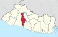
Ciudad Delgado
Location in El Salvador
Coordinates: 13°43′N89°10′W / 13.717°N 89.167°W / 13.717; -89.167
CountryFlag of El Salvador.svg  El Salvador
Department San Salvador Department
Area
  Municipality12.9 sq mi (33.4 km2)
Elevation
1,978 ft (603 m)
Population
 (2020)
  Municipality126,839
   Urban
118,341

Ciudad Delgado is a municipality in the San Salvador department of El Salvador. It is a part of the Metropolitan Area of San Salvador.

13°43′N89°10′W / 13.717°N 89.167°W / 13.717; -89.167

Related Research Articles

<span class="mw-page-title-main">Legislative Assembly of El Salvador</span> Government body of El Salvador

The Legislative Assembly is the legislative branch of the government of El Salvador.

<span class="mw-page-title-main">Aguilares, El Salvador</span> Salvadoran City

Aguilares is a municipality in the San Salvador department of El Salvador, located 33 km away from the city of San Salvador. The municipality measures 33.72 km² and as of 2006, had an estimated population of 73,300. Sugar cane cultivation is the major economic activity for the area.

Cuscatancingo is a municipality in the San Salvador department of El Salvador. It is located about 4 kilometres (2.5 mi) from the city of San Salvador and has a population of about 50,000. It is part of the San Salvador metropolitan area.

<span class="mw-page-title-main">El Paisnal</span> Municipality in San Salvador Department, El Salvador

El Paisnal is a municipality in the San Salvador department of El Salvador.

<span class="mw-page-title-main">Guazapa</span> Municipality in San Salvador

Guazapa is a municipality in the San Salvador department of El Salvador.

<span class="mw-page-title-main">Ilopango</span> Municipality in San Salvador Department, El Salvador

Ilopango is a town and municipality in the San Salvador department of El Salvador. It is a few miles east of the nation's capital, San Salvador and part of the San Salvador metropolitan area. It is located near Lake Ilopango, the country's largest lake at 72 square kilometers.

<span class="mw-page-title-main">Mejicanos</span> Municipality in San Salvador Department, El Salvador

Mejicanos is a San Salvador municipality in the San Salvador department of El Salvador.

<span class="mw-page-title-main">Soyapango</span> Municipality in San Salvador Department, El Salvador

Soyapango is a municipality in the San Salvador department of El Salvador. Soyapango is the country's largest municipality with 284,700 residents. Soyapango is a satellite city of San Salvador and it is the main thoroughfare between San Salvador and the eastern part of the country, and nearly 70,000 vehicles travel through it every day. The nickname for this satellite city is Soya.

San Juan Tepezontes is a municipality in the La Paz department of El Salvador. Its name is a Hispanicization of a Nawat term meaning "many hills." It was incorporated in 1945. Its population as of 2004 was 3,269.

<span class="mw-page-title-main">Sesori</span> Municipality in San Miguel Department, El Salvador

Sesori is a municipality in the Department of San Miguel, El Salvador. This is where many of the local people come and get food, supplies, education and it is also here where they get transportation to larger cities. Its location was used by other surrounding villages as people came here to make use of telephone services provided by ANTEL.

<span class="mw-page-title-main">Nahulingo</span>

Nahulingo is a municipality in the Sonsonate department of El Salvador.

San Antonio del Monte is also a subdivision of Garafía in the island of La Palma in the Canary Islands

Asunción Mita is a town, with a population of 20,936 (2018), and a municipality in the Jutiapa department of Guatemala.

<span class="mw-page-title-main">Acajutla</span> City in Sonsonate Department, El Salvador

Acajutla is a seaport city in Sonsonate Department, El Salvador. The city is located at 13°35′24″N89°50′01″W on the Pacific coast of Central America and is El Salvador's principal seaport from which a large portion of the nation's exports of coffee, sugar, and Balsam of Peru are shipped. As a city, Acajutla is one of seventeen such districts in Sonsonate. As of 1992, the population of the city was 18,008.

<span class="mw-page-title-main">San Andrés, El Salvador</span>

San Andrés is a pre-Columbian site in El Salvador, whose occupation began around the year 900 BC as an agricultural town in the valley of Zapotitán in the department of La Libertad. This early establishment was vacated by the year 250 because of the enormous eruption of the caldera of Lago Ilopango, and was occupied again in the 5th Century, along with many other sites in the valley of Zapotitán. Between 600 and 900 AD, San Andrés was the capital of a Maya polity with supremacy over the other establishments of Valle de Zapotitán.

<span class="mw-page-title-main">Lempa River</span> River that flows through Guatemala, El Salvador and Honduras

The Lempa River is a 422-kilometre-long (262 mi) river in Central America.

<span class="mw-page-title-main">Casa Blanca, El Salvador</span> Archeological site in Chalchuapa, El Salvador.

Casa Blanca is a pre-Columbian Maya archeological site in Chalchuapa, El Salvador. The site possesses several pyramids dating to the Late Preclassic period and the Classic period. This ruin is part of the Chalchuapa archaeological zone and displays influences from the Olmecs and from Teotihuacan. It is closely related to the ruins of Tazumal and San Andrés. The government purchased the park in 1977 and it was given the name of the coffee plantation upon which it was situated. There are many pyramids at Casa Blanca but only two have been partially restored. Casa Blanca is located in the department of Santa Ana. Casa Blanca has been closed to the public and is undergoing restoration work; it has a site museum with exhibits that include Maya ceramics and other artifacts.

<span class="mw-page-title-main">Estadio Jorge "El Mágico" González</span> Salvadoran football stadium

Estadio Nacional Jorge "El Mágico" González is a football stadium in San Salvador. It is named after Salvadoran star player Mágico González. The stadium has a capacity of 20,000 and was previously known as "Estadio Nacional Flor Blanca", referring to the name of the San Salvador neighborhood where it is located.

Chilanga is a municipality in the Morazán department of El Salvador.

The Apastepeque Volcanic Field is in El Salvador, Central America. The volcanic field is 8 kilometers north of a small town in central El Salvador called San Vicente. The last eruption of the volcano is unknown, however scientists have concluded that it was around 10, 000 years ago.