Deltana, Alaska

Last updated

Deltana, Alaska
CDP
USA Alaska location map.svg
Red pog.svg
Deltana, Alaska
Location within the state of Alaska
Coordinates: 63°57′50″N145°24′32″W / 63.96389°N 145.40889°W / 63.96389; -145.40889
Country United States
State Alaska
Census Area Southeast Fairbanks
Government
   State senator Click Bishop (R)
   State rep. Mike Cronk (R)
Area
[1]
  Total570.14 sq mi (1,476.65 km2)
  Land568.18 sq mi (1,471.57 km2)
  Water1.96 sq mi (5.08 km2)
Population
 (2020)
  Total2,359
  Density4.15/sq mi (1.60/km2)
Time zone UTC-9 (Alaska (AKST))
  Summer (DST) UTC-8 (AKDT)
ZIP code
99737
Area code 907
FIPS code 02-18675

Deltana is a census-designated place (CDP) in the Southeast Fairbanks Census Area, Alaska, United States. At the 2020 census, the population was 2,359, up from 2,251 in 2010. [2] Native inhabitants are Tanana Athabaskans.

Contents

History

In 1904, the U.S. Army Signal Corps built the McCarty Telegraph station on a site near a roadhouse established the previous year at the confluence of the Tanana and Delta rivers. The Chisana gold strike of 1913 brought many hopeful prospectors to the area. In the 1920s, many American Bison were brought to the area, and in 1927, the name was changed to Buffalo Center.

In 1942, five miles south of Deltana, Fort Greely was constructed. Beef cattle were shipped during the 1950s, and during the 1970s, the local economy was given another boost with the completion of the trans-Alaska pipeline.

In 1980, 70,000 acres (280 km2) of land were set aside as the Delta Bison Range to confine the bison and separate the expanding herd from local farmland.

Geography

Deltana is located at 63°57′50″N145°24′32″W / 63.96389°N 145.40889°W / 63.96389; -145.40889 (63.963825, -145.408931). [3]

According to the United States Census Bureau, the CDP has a total area of 565.2 square miles (1,464 km2), of which, 562.2 square miles (1,456 km2) of it is land and 3.0 square miles (7.8 km2) of it (0.52%) is water.

Demographics

Historical population
CensusPop.Note
2000 1,570
2010 2,25143.4%
2020 2,3594.8%
U.S. Decennial Census [4]

Deltana first appeared on the 2000 U.S. Census as a census-designated place (CDP).

As of the census [5] of 2000, there were 1,570 people, 539 households, and 417 families residing in the CDP. The population density was 2.8 inhabitants per square mile (1.1/km2). There were 669 housing units at an average density of 1.2 per square mile (0.46/km2). The racial makeup of the CDP was 91.6% White, 1.2% Black or African American, 0.9% Native American, 1.1% Asian, 0.4% from other races, and 4.8% from two or more races. 1.2% of the population were Hispanic or Latino of any race.

Deltana has the second highest percentage of residents, having been born in Ukraine in the United States at 8.4%, with an even higher total percentage of residents being Ukrainians or having Ukrainian ancestry. [6]

There were 539 households, out of which 36.5% had children under the age of 18 living with them, 69.2% were married couples living together, 5.0% had a female householder with no husband present, and 22.6% were non-families. 19.1% of all households were made up of individuals, and 6.1% had someone living alone who was 65 years of age or older. The average household size was 2.87, and the average family size was 3.30.

In the CDP, the population was spread out, with 31.4% under the age of 18, 6.9% from 18 to 24, 23.5% from 25 to 44, 30.9% from 45 to 64, and 7.3% who were 65 years of age or older. The median age was 39 years. For every 100 females, there were 107.4 males. For every 100 females age 18 and over, there were 105.9 males.

Income

The median income for a household in the CDP was $50,066, and the median income for a family was $53,021. Males had a median income of $42,500 versus $31,042 for females. The per capita income for the CDP was $18,446. About 12.1% of families and 15.1% of the population were below the poverty line, including 19.9% of those under age 18 and 0.9% of those age 65 or over.

Related Research Articles

<span class="mw-page-title-main">Southeast Fairbanks Census Area, Alaska</span> Census area in Alaska, United States

Southeast Fairbanks Census Area is a census area located in the U.S. state of Alaska. As of the 2020 census, the population was 6,808, down from 7,029 in 2010. It is part of the unorganized borough and therefore has no borough seat. Its largest communities are Deltana and Tok, both unincorporated CDPs.

<span class="mw-page-title-main">Cantwell, Alaska</span> Census-designated place in Alaska, United States

Cantwell is a census-designated place (CDP) in Denali Borough, Alaska, United States. As of the 2020 census, the population of the CDP was 200.

<span class="mw-page-title-main">Denali Park (CDP), Alaska</span> Census-designated place in Alaska, United States

Denali Park, formerly McKinley Park, is a census-designated place (CDP) in Denali Borough, in the U.S. state of Alaska. As of the 2020 census, the population of the CDP was 163, down from 185 at the 2010 census.

<span class="mw-page-title-main">Salcha, Alaska</span> Census-designated place in Alaska, United States

Salcha is a census-designated place (CDP) in Fairbanks North Star Borough in the U.S. state of Alaska. It is part of the Fairbanks, Alaska Metropolitan Statistical Area. The population was 1,095 at the 2010 census, up from 854 in 2000.

<span class="mw-page-title-main">Petersville, Alaska</span> Census-designated place in Alaska, United States

Petersville is a census-designated place (CDP) in Matanuska-Susitna Borough, Alaska, United States. It is part of the Anchorage Metropolitan Area. The population was 27 at the 2020 census.

<span class="mw-page-title-main">Big Delta, Alaska</span> CDP in Alaska, United States

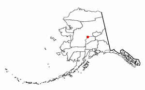
Big Delta is a census-designated place (CDP) in Southeast Fairbanks Census Area, Alaska, United States. The population was 591 at the 2010 census, down from 749 in 2000. Big Delta is at the confluence of the Delta River and the Tanana River and gets its name from the huge river delta formed by the confluence.

<span class="mw-page-title-main">Dot Lake, Alaska</span> CDP in Alaska, United States

Dot Lake is a census-designated place (CDP) in Southeast Fairbanks Census Area, Alaska, United States. It is located on the Alaska Highway between Delta Junction and Tok. The population was 13 at the 2010 census, down from 19 in 2000.

<span class="mw-page-title-main">Fort Greely, Alaska</span> CDP in Alaska, United States

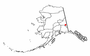
Fort Greely is a census-designated place (CDP) in Southeast Fairbanks Census Area, Alaska, United States. It is home to the Fort Greely military installation. At the 2010 census the population was 539, up from 461 in 2000.

<span class="mw-page-title-main">Healy Lake, Alaska</span> CDP in Alaska, United States

Healy Lake is a census-designated place (CDP) in Southeast Fairbanks Census Area, Alaska, United States. The population was 13 at the 2010 census, down from 37 in 2000.

<span class="mw-page-title-main">Northway Junction, Alaska</span> CDP in Alaska, United States

Northway Junction was a census-designated place (CDP) in Southeast Fairbanks Census Area, Alaska, United States. It was merged with Northway CDP prior to the 2020 Census. The population was 54 at the 2010 census, down from 72 in 2000.

Tanacross is a census-designated place (CDP) in Southeast Fairbanks Census Area, Alaska, United States. At the 2010 census the population was 136, down from 140 in 2000. It hosts an air tanker base.

<span class="mw-page-title-main">Tetlin, Alaska</span> CDP in Alaska, United States

Tetlin is a census-designated place (CDP) in Southeast Fairbanks Census Area, Alaska, United States. At the 2010 census the population was 127, up from 117 in 2000.

Paxson is a census-designated place (CDP) in Copper River Census Area, Alaska, United States. As of the 2020 census, its population was 26, down from 40 in 2010. It is located on the Richardson Highway at the junction with the Denali Highway.

Silver Springs is a census-designated place (CDP) in Copper River Census Area, Alaska, United States. At the 2020 census the population was 111, down from 114 in 2010.

Willow Creek is a census-designated place (CDP) in Copper River Census Area, Alaska, United States. At the 2020 census the population was 190, down from 191 in 2010.

Birch Creek is a census-designated place (CDP) in Yukon-Koyukuk Census Area, Alaska, United States. The population was 33 at the 2010 census, up from 28 in 2000.

<span class="mw-page-title-main">Lake Minchumina, Alaska</span> CDP in Alaska, United States

Lake Minchumina is a census-designated place (CDP) in Yukon-Koyukuk Census Area, Alaska, United States. As of the 2020 census, the population of the CDP is 30.

Minto is a census-designated place (CDP) in Yukon-Koyukuk Census Area, Alaska, United States. As of the 2020 census, the population of the CDP is 150, down from 210 in 2010. The name is an anglicized version of the Lower Tanana Athabaskan name Menhti, meaning 'among the lakes'. After repeated flooding the village was relocated to its present location in 1969. The former village site is now known as Old Minto.

<span class="mw-page-title-main">Tresckow, Pennsylvania</span> Census-designated place in Pennsylvania, United States

Tresckow, formerly known as Dutchtown, is an unincorporated community and census-designated place (CDP) in Carbon County, Pennsylvania, United States. It is part of Northeastern Pennsylvania and is located west of Junedale and Beaver Meadows, which share the same road network. The community has deep roots in the anthracite coal mining and transportation industries.

<span class="mw-page-title-main">Star Valley Ranch, Wyoming</span> Town in Wyoming, United States

Star Valley Ranch is a town in Lincoln County, Wyoming, United States. The population was 1,866 at the 2020 census. It was incorporated on November 8, 2005; at the 2000 census, it was only a census-designated place (CDP).

References

  1. "2020 U.S. Gazetteer Files". United States Census Bureau. Retrieved October 29, 2021.
  2. "2020 Census Data - Cities and Census Designated Places" (Web). State of Alaska, Department of Labor and Workforce Development. Retrieved October 31, 2021.
  3. "US Gazetteer files: 2010, 2000, and 1990". United States Census Bureau. February 12, 2011. Retrieved April 23, 2011.
  4. "U.S. Decennial Census". Census.gov. Retrieved June 6, 2013.
  5. "U.S. Census website". United States Census Bureau . Retrieved January 31, 2008.
  6. "Top 101 cities with the most residents born in Ukraine (population 500+)". city-data.com. Retrieved August 12, 2008.